Back to forecast
On This Day in 2022: Hurricane Ian Peaks At Category 5 Status
September 27, 2023 at 10:28 PM EDT
By WeatherBug Meteorologist, Matt Mehallow
Today marks the one-year anniversary of Hurricane Ian briefly reaching Category 5 status in the eastern Gulf of Mexico before weakening slightly. The storm would bombard Florida as a devastating Category 4 hurricane.
After a relatively slow start to the 2022 Atlantic Hurricane Season, tropical activity picked up in mid-September. The National Hurricane Center began following a tropical disturbance on September 19 located several hundred miles east of the Windward Islands. This disturbance slowly became more organized as it proceeded westward and developed into Tropical Depression Nine as it moved through the central Caribbean Sea well southeast of Jamaica.
Tropical Storm Ian formed late on September 23, but only slowly intensified over the following days as it battled moderate wind shear. By September 26, Ian reached hurricane strength while located a little over 300 miles south of Cuba. Ian strengthened rapidly prior to striking western Cuba early in the morning of September 27 as a category 3 hurricane with 125 mph winds.
Ian weakened only slightly as it crossed Cuba, then strengthened into a powerful category 5 storm. The peak intensity of Ian was sustained winds of 160 mph after it was upgraded in the post-season analysis. Ian weakened slightly before making its second landfall just south of Punta Gorda, Fla., on September 28 with 155 mph sustained winds.
A catastrophic storm surge struck the west coast of Florida south of Tampa, and over 20 inches of rain caused major flooding across much of the state. Ian slowly crossed Florida and pushed off the east coast as a tropical storm with peak sustained winds around 70 mph during the late morning hours of September 29.
Ian turned northward and re-strengthened to a category 1 hurricane before its third and final landfall on the South Carolina coast near Georgetown on September 30. Maximum sustained winds as high as 80 mph pushed a 3-to-6-foot storm surge onshore along the coast of northeastern South Carolina and southeastern North Carolina.
Rainfall totals in coastal regions of the Carolinas, Virginia and Maryland ranged from three to over 10 inches. In Charleston, S.C., 10.75 inches of rain was observed.
As the storm pushed inland, cool air wrapped around the storm's center, causing Ian to quickly become a post-tropical cyclone. Ian was responsible for over 150 direct and indirect deaths and over $112 billion in damage, making it the costliest hurricane in Florida’s history and the third costliest in United States history.
---
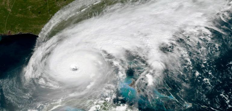
Story Image: Hurricane Ian at peak intensity while approaching southeast Florida. (Courtesy of the Geostationary Operational Environmental Satellite Program via Wikimedia Commons)
After a relatively slow start to the 2022 Atlantic Hurricane Season, tropical activity picked up in mid-September. The National Hurricane Center began following a tropical disturbance on September 19 located several hundred miles east of the Windward Islands. This disturbance slowly became more organized as it proceeded westward and developed into Tropical Depression Nine as it moved through the central Caribbean Sea well southeast of Jamaica.
Tropical Storm Ian formed late on September 23, but only slowly intensified over the following days as it battled moderate wind shear. By September 26, Ian reached hurricane strength while located a little over 300 miles south of Cuba. Ian strengthened rapidly prior to striking western Cuba early in the morning of September 27 as a category 3 hurricane with 125 mph winds.
Ian weakened only slightly as it crossed Cuba, then strengthened into a powerful category 5 storm. The peak intensity of Ian was sustained winds of 160 mph after it was upgraded in the post-season analysis. Ian weakened slightly before making its second landfall just south of Punta Gorda, Fla., on September 28 with 155 mph sustained winds.
A catastrophic storm surge struck the west coast of Florida south of Tampa, and over 20 inches of rain caused major flooding across much of the state. Ian slowly crossed Florida and pushed off the east coast as a tropical storm with peak sustained winds around 70 mph during the late morning hours of September 29.
Ian turned northward and re-strengthened to a category 1 hurricane before its third and final landfall on the South Carolina coast near Georgetown on September 30. Maximum sustained winds as high as 80 mph pushed a 3-to-6-foot storm surge onshore along the coast of northeastern South Carolina and southeastern North Carolina.
Rainfall totals in coastal regions of the Carolinas, Virginia and Maryland ranged from three to over 10 inches. In Charleston, S.C., 10.75 inches of rain was observed.
As the storm pushed inland, cool air wrapped around the storm's center, causing Ian to quickly become a post-tropical cyclone. Ian was responsible for over 150 direct and indirect deaths and over $112 billion in damage, making it the costliest hurricane in Florida’s history and the third costliest in United States history.
---
Story Image: Hurricane Ian at peak intensity while approaching southeast Florida. (Courtesy of the Geostationary Operational Environmental Satellite Program via Wikimedia Commons)