Back to forecast
On This Day: First Hook Echo Detected On Radar
April 8, 2021 at 02:20 PM EDT
By WeatherBug Sr. Meteorologist, James West
Although it is now synonymous with tornado detection, the first hook echo on weather radar was not recorded until April 9, 1953.
This historic hook echo, as is told by the Illinois Water Survey and several local newspaper articles, occurred because of a bit of luck and serendipity. In 1953, the Illinois State Water Survey was using one of the few radars designed to detect weather at the William Airport in Champaign, Ill. However, the focus of the study wasn’t severe thunderstorms, but instead to compare the radar signal with rainfall rates and totals from a rain gauge network.
Early on April 9, the radar was down for maintenance so that a radar technician, Don Staggs, could replace a piece of equipment. Although the radar was typically turned off in the evening, the maintenance meant that it remained on to make sure the repairs were successful.
As the radar made its scans that evening, a storm to the north of its location appeared clearly on the radar. The radar, being south of the storm, was able to scan the rear or southern flank of this powerful storm. From this perspective, a classic hook echo was detected. Staggs, noting the uniqueness of storm and using the equipped 35 mm camera, took pictures of the radar scope. These pictures are the first recorded hook echo in history.
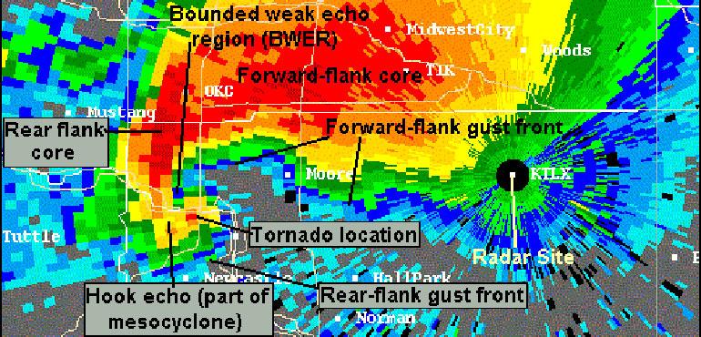
The hook echo, which is a radar return extending from a severe storm shaped like a fishhook, was, at the time, not a known way of detecting tornadoes within supercell thunderstorms. However, the pictures along with a storm survey of tornado damage associated with this storm, offered insight into the correlation of the radar data with tornado development.
These radar images provided groundbreaking insight into the development of tornadoes and the potential use of weather radars to detect the development of tornadoes. Today’s modern weather radar use complex computer algorithms to detect the conditions within a thunderstorm that can produce a tornado, offering minutes of extra time to alert people in the path of these tornadoes.
Credit: Illinois Water Survey, The News-Gazette
This historic hook echo, as is told by the Illinois Water Survey and several local newspaper articles, occurred because of a bit of luck and serendipity. In 1953, the Illinois State Water Survey was using one of the few radars designed to detect weather at the William Airport in Champaign, Ill. However, the focus of the study wasn’t severe thunderstorms, but instead to compare the radar signal with rainfall rates and totals from a rain gauge network.
Early on April 9, the radar was down for maintenance so that a radar technician, Don Staggs, could replace a piece of equipment. Although the radar was typically turned off in the evening, the maintenance meant that it remained on to make sure the repairs were successful.
As the radar made its scans that evening, a storm to the north of its location appeared clearly on the radar. The radar, being south of the storm, was able to scan the rear or southern flank of this powerful storm. From this perspective, a classic hook echo was detected. Staggs, noting the uniqueness of storm and using the equipped 35 mm camera, took pictures of the radar scope. These pictures are the first recorded hook echo in history.
The hook echo, which is a radar return extending from a severe storm shaped like a fishhook, was, at the time, not a known way of detecting tornadoes within supercell thunderstorms. However, the pictures along with a storm survey of tornado damage associated with this storm, offered insight into the correlation of the radar data with tornado development.
These radar images provided groundbreaking insight into the development of tornadoes and the potential use of weather radars to detect the development of tornadoes. Today’s modern weather radar use complex computer algorithms to detect the conditions within a thunderstorm that can produce a tornado, offering minutes of extra time to alert people in the path of these tornadoes.
Credit: Illinois Water Survey, The News-Gazette