Back to forecast
On This Day: Flooding Rain Breaks Through West Virginia Record Books
June 23, 2021 at 07:03 AM EDT
By WeatherBug Sr. Meteorologist, Chad Merrill
West Virginia’s mountain-valley landscape is prone to the weather hazard that kills the most people every year; flooding. On this day 71 years ago, a flash flood not only made it into the state’s record books but was powerful enough to litter farmland with debris from rockslides.
Central West Virginia averages at least 50 inches of precipitation each year. The highest peaks along the spine of the Allegheny Mountain range in the central part of the state tally as much as 100 inches of precipitation.
West Virginia has the highest average elevation of any state east of the Mississippi River and for that reason, flooding is the severest natural hazard in the state. Uneven topography with steep mountainside adjacent to narrow valleys allow rainwater and melted snow in the winter to run off readily into creeks, streams and rivers. West Virginia is notorious for flooding from tropical systems, heavy rain on top of snowpack in the winter and torrential downpours that trigger flash flooding in the summer.
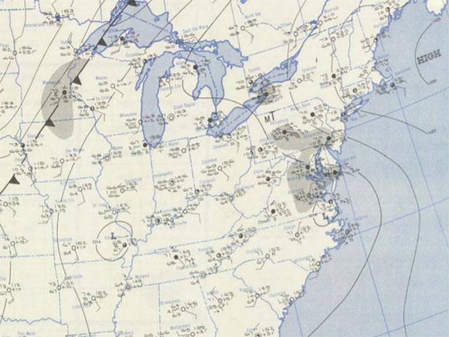
One event that stands out in West Virginia’s record books occurred on this day in 1949. The atmospheric setup was ripe for heavy rain with low pressure in southeast Virginia and a strong high pressure off the New England coast. The two pressure systems worked in tandem to bring an influx of Atlantic moisture into West Virginia in the form of heavy rain showers late on June 17. The persistent rain lead to severe flash flooding on June 18 along the south branch of the Potomac River, which serves as the border between West Virginia and Maryland.
One spot 49 miles south of the Potomac River called Brushy Run, W.Va., measured 12.02 inches. To put things in perspective, 25 percent of central West Virginia’s average annual precipitation fell in a 24-hour period during this storm. That 24-hour precipitation record for West Virginia still stands to this date.
The severe flooding claimed eight lives and several people were reported missing. More than 2,000 residents were forced from their homes and the flooding totaled $7 million ($75,410,000 in 2020). Debris from rockslides was significant enough to cover farmlands in the valleys and fill small streams enough for them to change their course. The water supply became contaminated and communication and power service was disrupted.
Since then, several other significant flooding disasters have occurred. The Great Ohio River Flood in January 1937 hit southwest West Virginia. The entire Ohio River from Point Pleasant, W.Va., to Cairo, Ill., experienced record flooding. Hurricane Juan’s moisture generated up to 10 inches of rain in West Virginia in early November of 1985, causing $570 million in damages. Most recently, a stationary front was the catalyst that produced 8 to 10 inches of rain in central West Virginia on June 23, 2016. The catastrophic flooding killed 23 people and damage estimates exceeded $50 million.
------
Story Image: The weather map depiction for June 18, 1949, the day West Virginia established its 24-hour precipitation record at Brushy Run. (Photo courtesy of the NOAA Central Library Data Imaging Project)
Central West Virginia averages at least 50 inches of precipitation each year. The highest peaks along the spine of the Allegheny Mountain range in the central part of the state tally as much as 100 inches of precipitation.
West Virginia has the highest average elevation of any state east of the Mississippi River and for that reason, flooding is the severest natural hazard in the state. Uneven topography with steep mountainside adjacent to narrow valleys allow rainwater and melted snow in the winter to run off readily into creeks, streams and rivers. West Virginia is notorious for flooding from tropical systems, heavy rain on top of snowpack in the winter and torrential downpours that trigger flash flooding in the summer.
One event that stands out in West Virginia’s record books occurred on this day in 1949. The atmospheric setup was ripe for heavy rain with low pressure in southeast Virginia and a strong high pressure off the New England coast. The two pressure systems worked in tandem to bring an influx of Atlantic moisture into West Virginia in the form of heavy rain showers late on June 17. The persistent rain lead to severe flash flooding on June 18 along the south branch of the Potomac River, which serves as the border between West Virginia and Maryland.
One spot 49 miles south of the Potomac River called Brushy Run, W.Va., measured 12.02 inches. To put things in perspective, 25 percent of central West Virginia’s average annual precipitation fell in a 24-hour period during this storm. That 24-hour precipitation record for West Virginia still stands to this date.
The severe flooding claimed eight lives and several people were reported missing. More than 2,000 residents were forced from their homes and the flooding totaled $7 million ($75,410,000 in 2020). Debris from rockslides was significant enough to cover farmlands in the valleys and fill small streams enough for them to change their course. The water supply became contaminated and communication and power service was disrupted.
Since then, several other significant flooding disasters have occurred. The Great Ohio River Flood in January 1937 hit southwest West Virginia. The entire Ohio River from Point Pleasant, W.Va., to Cairo, Ill., experienced record flooding. Hurricane Juan’s moisture generated up to 10 inches of rain in West Virginia in early November of 1985, causing $570 million in damages. Most recently, a stationary front was the catalyst that produced 8 to 10 inches of rain in central West Virginia on June 23, 2016. The catastrophic flooding killed 23 people and damage estimates exceeded $50 million.
------
Story Image: The weather map depiction for June 18, 1949, the day West Virginia established its 24-hour precipitation record at Brushy Run. (Photo courtesy of the NOAA Central Library Data Imaging Project)