Back to forecast
On This Day in 1985: Hurricane Kate Strikes Florida
November 21, 2022 at 04:47 AM EST
By WeatherBug's Richard Romkee
On this day in 1985, Hurricane Kate lashed the Florida Panhandle.
The system that would become Kate started as a weak tropical wave east of the Bahamas on November 13, 1985, and it was in a very healthy environment for additional strengthening. After a few days of gradual organization, NOAA Hurricane Hunter Aircraft found that the system had reached tropical storm strength earning the name "Kate" on November 15.
Kate began to quickly gather strength as it gradually moved westward. By the afternoon of November 16, Kate reached hurricane strength with sustained winds to 75 mph. The outer parts of Kate’s circulation brought heavy rain, flooding and gusty winds to Puerto Rico which unfortunately led to damaged homes and capsized boats near San Juan.
As Kate pushed westward, it brought heavy rain and flooding to the Turks and Caicos Islands as well as to Jamaica. Seven fatalities and over $8.3 million in damage were reported as mudslides damaged homes and large amounts of infrastructure across the islands. Around this time, hurricane watches were issued for the eastern and southern coasts of Florida including the Florida Keys.
Cuba was next in line for Kate’s wrath, and by the evening of November 18 the storm made landfall in the province of Cayo Romano. By this time, Kate was a Category 2 storm with sustained winds to 110 mph and a minimum central pressure of 968 mb. Kate skirted the northern coast of Cuba until it emerged out into the Gulf of Mexico on November 19.
Sustained winds to 75 mph and wind gusts as high as 104 mph in central Cuba, as well as waves up to 9 feet high on the coast, caused significant damage across the island nation. Ten deaths were reported in Cuba, with 50 injuries as well. Over 88,000 homes were damaged, with around 4,000 completely destroyed: this left nearly 477,000 residents homeless in the wake of the storm. Croplands were also hard hit, with 37,000 tons of sugar, 155,000 tons of bananas and 97,000 tons of various other crops ruined by Kate’s fierce wind and rain.
Kate did weaken slightly as it raked Cuba, but it quickly regained strength over the Gulf of Mexico as it skirted the Florida Keys. Strong winds and heavy rain led to power outages, and electrical faults led to a fatal mobile home fire. Intense surf and winds also led to a boat capsizing in the Lower Keys which resulted in two deaths.
By November 20, the storm reached maximum intensity with a central minimum pressure of 954 mb and sustained winds to 120 mph, putting it at Category 3 status on the Saffir-Simpson scale. That day, hurricane warnings were hoisted for the Gulf Coast from Bay St. Louis, Miss., to St. Marks, Fla. Ahead of Kate’s arrival, 120,000 evacuations were ordered from numerous communities and oil platforms across the northeastern Gulf of Mexico.
Fortunately for those along the coast, Kate weakened as it recurved to the northeast thanks to increasing upper-level winds and cooler sea surface temperatures. Hurricane Kate made landfall as a Category 2 storm during the afternoon of November 21, 1985, with sustained winds to 100 mph and a minimum central pressure of 967 millibars. This set the record for latest hurricane landfall in U.S. history, a record which has yet to be broken.
The Florida Panhandle was hit very hard by Kate. Storm surge reached 11 feet at Cape San Blas, with wind gusts to 78 mph and 8.32 inches of rain lashing Panama City. Water dealt significant damage to the entire region, with storm surge flooding damaging 150 homes in Wakulla County just east of the landfall point. Roads and bridges were also washed out, many of which had recently been replaced after sustaining damage during a near miss from Hurricane Elena earlier in the year.
As with any hurricane, winds were also a major cause of damage across the affected area. Panama City experienced damage to a motel, a fishing pier, two homes and a local federal building which lost its roof as the storm blew through. Franklin County, just east of the landfall point, reported 242 homes damaged or destroyed with 5.4 miles of roadway damaged across the county as well.
Trees and power lines across the Southeast also took a beating from Kate’s ferocious winds. Coastal areas of Florida were battered, with 30,000 power outages reported. As the tempest moved northwest of Tallahassee, 90 percent of the city (around 80,000 residents) lost power, with a falling tree killing one resident and severely injuring another.
Georgia was hit hard by Kate as well, with flash flooding and gusty winds causing severe damage. A tree fell on a car in Thomasville, Ga., leading to one death, with property and road damage reaching $141 million across the state in 2022 dollars. A further $140 million in crop damage was reported in Georgia, with 3,000 power outages caused by Kate’s passage.
Kate weakened to tropical storm intensity as it quickly traversed South Carolina on November 23, but it still caused significant damage. Gusty winds knocked down trees causing damage to four cars and a mobile home near Beaufort, S.C., with 48,000 residents losing power across the state. Anywhere from 2 to 6 inches of rain fell across the Carolinas, which produced flash flooding.
Although Kate was quite severe, causing 15 deaths and $1.9 billion in damage, the name was not retired. The name Kate was last used for a weak tropical storm in 2021, and will be used again in 2027.
Source: NWS, NHC, Wikipedia.org
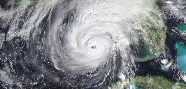
Story Image: Hurricane Kate at peak intensity off the west coast of Florida on November 20, 1985. (NOAA via Wikimedia Commons)
The system that would become Kate started as a weak tropical wave east of the Bahamas on November 13, 1985, and it was in a very healthy environment for additional strengthening. After a few days of gradual organization, NOAA Hurricane Hunter Aircraft found that the system had reached tropical storm strength earning the name "Kate" on November 15.
Kate began to quickly gather strength as it gradually moved westward. By the afternoon of November 16, Kate reached hurricane strength with sustained winds to 75 mph. The outer parts of Kate’s circulation brought heavy rain, flooding and gusty winds to Puerto Rico which unfortunately led to damaged homes and capsized boats near San Juan.
As Kate pushed westward, it brought heavy rain and flooding to the Turks and Caicos Islands as well as to Jamaica. Seven fatalities and over $8.3 million in damage were reported as mudslides damaged homes and large amounts of infrastructure across the islands. Around this time, hurricane watches were issued for the eastern and southern coasts of Florida including the Florida Keys.
Cuba was next in line for Kate’s wrath, and by the evening of November 18 the storm made landfall in the province of Cayo Romano. By this time, Kate was a Category 2 storm with sustained winds to 110 mph and a minimum central pressure of 968 mb. Kate skirted the northern coast of Cuba until it emerged out into the Gulf of Mexico on November 19.
Sustained winds to 75 mph and wind gusts as high as 104 mph in central Cuba, as well as waves up to 9 feet high on the coast, caused significant damage across the island nation. Ten deaths were reported in Cuba, with 50 injuries as well. Over 88,000 homes were damaged, with around 4,000 completely destroyed: this left nearly 477,000 residents homeless in the wake of the storm. Croplands were also hard hit, with 37,000 tons of sugar, 155,000 tons of bananas and 97,000 tons of various other crops ruined by Kate’s fierce wind and rain.
Kate did weaken slightly as it raked Cuba, but it quickly regained strength over the Gulf of Mexico as it skirted the Florida Keys. Strong winds and heavy rain led to power outages, and electrical faults led to a fatal mobile home fire. Intense surf and winds also led to a boat capsizing in the Lower Keys which resulted in two deaths.
By November 20, the storm reached maximum intensity with a central minimum pressure of 954 mb and sustained winds to 120 mph, putting it at Category 3 status on the Saffir-Simpson scale. That day, hurricane warnings were hoisted for the Gulf Coast from Bay St. Louis, Miss., to St. Marks, Fla. Ahead of Kate’s arrival, 120,000 evacuations were ordered from numerous communities and oil platforms across the northeastern Gulf of Mexico.
Fortunately for those along the coast, Kate weakened as it recurved to the northeast thanks to increasing upper-level winds and cooler sea surface temperatures. Hurricane Kate made landfall as a Category 2 storm during the afternoon of November 21, 1985, with sustained winds to 100 mph and a minimum central pressure of 967 millibars. This set the record for latest hurricane landfall in U.S. history, a record which has yet to be broken.
The Florida Panhandle was hit very hard by Kate. Storm surge reached 11 feet at Cape San Blas, with wind gusts to 78 mph and 8.32 inches of rain lashing Panama City. Water dealt significant damage to the entire region, with storm surge flooding damaging 150 homes in Wakulla County just east of the landfall point. Roads and bridges were also washed out, many of which had recently been replaced after sustaining damage during a near miss from Hurricane Elena earlier in the year.
As with any hurricane, winds were also a major cause of damage across the affected area. Panama City experienced damage to a motel, a fishing pier, two homes and a local federal building which lost its roof as the storm blew through. Franklin County, just east of the landfall point, reported 242 homes damaged or destroyed with 5.4 miles of roadway damaged across the county as well.
Trees and power lines across the Southeast also took a beating from Kate’s ferocious winds. Coastal areas of Florida were battered, with 30,000 power outages reported. As the tempest moved northwest of Tallahassee, 90 percent of the city (around 80,000 residents) lost power, with a falling tree killing one resident and severely injuring another.
Georgia was hit hard by Kate as well, with flash flooding and gusty winds causing severe damage. A tree fell on a car in Thomasville, Ga., leading to one death, with property and road damage reaching $141 million across the state in 2022 dollars. A further $140 million in crop damage was reported in Georgia, with 3,000 power outages caused by Kate’s passage.
Kate weakened to tropical storm intensity as it quickly traversed South Carolina on November 23, but it still caused significant damage. Gusty winds knocked down trees causing damage to four cars and a mobile home near Beaufort, S.C., with 48,000 residents losing power across the state. Anywhere from 2 to 6 inches of rain fell across the Carolinas, which produced flash flooding.
Although Kate was quite severe, causing 15 deaths and $1.9 billion in damage, the name was not retired. The name Kate was last used for a weak tropical storm in 2021, and will be used again in 2027.
Source: NWS, NHC, Wikipedia.org
Story Image: Hurricane Kate at peak intensity off the west coast of Florida on November 20, 1985. (NOAA via Wikimedia Commons)