Back to forecast
On This Day in 1990: Destructive Thunderstorms Struck Kansas
June 19, 2023 at 08:18 AM EDT
By WeatherBug Meteorologist, Fred Allen
Forever etched in Kansas weather history, a destructive line of thunderstorms plowed across the south-central part of the state early at night. It was so notable it would later be given the monicker the “Inland Hurricane”.
A little digging into the weather ingredients on June 19th, 1990, revealed a stalled front connected to an area of low pressure in northeastern Kansas. A sun-filled sky south of the front boosted temperatures to the upper 90s to lower triple-digits compared to lower to middle 80s to its north. The other notable part is that such intense heating effectively led to a large dry layer near the Earth's surface.
Once a compact upper-level disturbance arrived less than an hour before sunset, a protective lid holding thunderstorms at bay no longer existed. And, at 8:15 p.m. CDT that day, an intense thunderstorm formed near Pratt, Kan. The path was initially east, following U.S. Route 400 into Wichita, Kan., before curving to the northeast along Interstate 35. It was during this time the thunderstorm had grown into a destructive line.
The damage path was immense, leaving a large area buffeted by 65 to 120-mph straight-line wind gusts across parts of six south-central Kansas counties. Nearly 20,000 homes lost power in Wichita, Kan., and next up were Butler and Harvey counties, all occurring after sunset no less. Approximately 60,000 homes lost power, some for up to five or six days.
Later, the thunderstorm complex was labeled a “derecho”, or more notably, the “Inland Hurricane”. The stats are mind-boggling, leaving more than $80 million dollars in 1990 damage. This is equivalent to more than $186 million in 2023 dollars!
Thankfully, no deaths were reported, but 33 people were injured. The peak wind gust of 116 mph was on part with a low-end Category 3 hurricane on the Saffir-Simpson Hurricane Wind Scale. Given the new Enhanced Fujita Wind Scale, the same gust would be equivalent to an EF-2 intensity tornado. Power was knocked out to all Wichita, Kan., television stations, and all but one of the city’s radio stations lost power, including NOAA weather radio.
The government’s Storm Prediction Center storm reports log puts into context how much of a beating Reno, Kingman, Sedgwick, Butler, and Harvey counties took. Gusts more than 80 mph peppered Lake Cheney, Kan., while numerous reports of power lines down and tree damage accumulated over time in Sedgwick County leading to major damage. Sixty to 70 mph thunderstorm wind gusts destroyed a trailer in Andover, Kan., and blew down a building wall in Augusta, Kan.
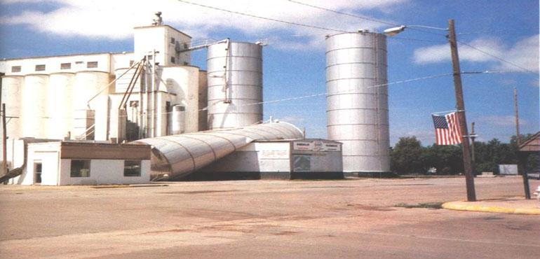
A grain bin in Furley, Kan., was toppled and heavily damaged, while a part of a hangar at Jabara Airport was whisked away in the violent thunderstorms, flipping a home-built airplane. A silo was left a mangled mess, laying across the ground at the Valley Center branch of Andale, Kan., co-op. It’s clear this day will never be forgotten across south-central Kansas.
---
Story Image: Wind damage to a silo is seen at the Valley Center branch of the Andale, Kan., co-op. (Photo by Vanessa Mayes and courtesy "Year of the Storms")
Source: NWS, John Davies
A little digging into the weather ingredients on June 19th, 1990, revealed a stalled front connected to an area of low pressure in northeastern Kansas. A sun-filled sky south of the front boosted temperatures to the upper 90s to lower triple-digits compared to lower to middle 80s to its north. The other notable part is that such intense heating effectively led to a large dry layer near the Earth's surface.
Once a compact upper-level disturbance arrived less than an hour before sunset, a protective lid holding thunderstorms at bay no longer existed. And, at 8:15 p.m. CDT that day, an intense thunderstorm formed near Pratt, Kan. The path was initially east, following U.S. Route 400 into Wichita, Kan., before curving to the northeast along Interstate 35. It was during this time the thunderstorm had grown into a destructive line.
The damage path was immense, leaving a large area buffeted by 65 to 120-mph straight-line wind gusts across parts of six south-central Kansas counties. Nearly 20,000 homes lost power in Wichita, Kan., and next up were Butler and Harvey counties, all occurring after sunset no less. Approximately 60,000 homes lost power, some for up to five or six days.
Later, the thunderstorm complex was labeled a “derecho”, or more notably, the “Inland Hurricane”. The stats are mind-boggling, leaving more than $80 million dollars in 1990 damage. This is equivalent to more than $186 million in 2023 dollars!
Thankfully, no deaths were reported, but 33 people were injured. The peak wind gust of 116 mph was on part with a low-end Category 3 hurricane on the Saffir-Simpson Hurricane Wind Scale. Given the new Enhanced Fujita Wind Scale, the same gust would be equivalent to an EF-2 intensity tornado. Power was knocked out to all Wichita, Kan., television stations, and all but one of the city’s radio stations lost power, including NOAA weather radio.
The government’s Storm Prediction Center storm reports log puts into context how much of a beating Reno, Kingman, Sedgwick, Butler, and Harvey counties took. Gusts more than 80 mph peppered Lake Cheney, Kan., while numerous reports of power lines down and tree damage accumulated over time in Sedgwick County leading to major damage. Sixty to 70 mph thunderstorm wind gusts destroyed a trailer in Andover, Kan., and blew down a building wall in Augusta, Kan.
A grain bin in Furley, Kan., was toppled and heavily damaged, while a part of a hangar at Jabara Airport was whisked away in the violent thunderstorms, flipping a home-built airplane. A silo was left a mangled mess, laying across the ground at the Valley Center branch of Andale, Kan., co-op. It’s clear this day will never be forgotten across south-central Kansas.
---
Story Image: Wind damage to a silo is seen at the Valley Center branch of the Andale, Kan., co-op. (Photo by Vanessa Mayes and courtesy "Year of the Storms")
Source: NWS, John Davies