Back to forecast
On This Day in 1995: Mayfest Supercell Erupts in Fort Worth, Texas
May 12, 2021 at 05:57 PM EDT
By WeatherBug's Chris Sayles
Cinco de Mayo in 1995 showcased some of the most tumultuous weather across the Lone Star State. A stormy afternoon prompted a supercell thunderstorm that bombarded Fort Worth, Texas.
The Fort Worth region was in the crosshairs of these deadly storms during the afternoon on May 5, 1995. It all started from a cluster of storms that energized from the tropical moisture often found across the south. Strong updrafts and wind shear would help to create these powerful storms which led to a bow echo readily seen on radar at the time, indicative of a supercell thunderstorm.
With very little warning, the Fort Worth region was blasted by these robust thunderstorms. Hail up to the size of 4 inches (grapefruit size) pummeled the city. The massive hail paired with gusty winds over 57 mph and rain rates more than 2 inches left a trail of destruction. In fact, this weather event eclipsed a town event known as Mayfest and leading to more deadly outcomes.
Without proper protection, the town was fell victim to this devastating supercell. More than 400 people were injured with 60 to 100 people having to be hospitalized due to injuries sustained from the storm. Sadly, heavy rain resulting in flooding and lightning strikes led to 16 people losing their lives. Not only that, but multiple cars, homes and businesses were damaged as the storm ripped through the city. Over 55,000 people lost power and damages were said to be over $2 billion.
Due to the rapid development of this storm, this is believed to be the main reasons for the deadly outcome. Technology was less advanced at the time, so citizens not near a television or radio had no prior knowledge of the incoming storms. The good news, this unfortunate event helped to streamline a volunteer alert service known as the Radio Amateur Civil Emergency Service (RACES) and an official forecasting center for the Mayfest event to prevent this from happening in the future.
Source(s): National Weather Service (NWS)
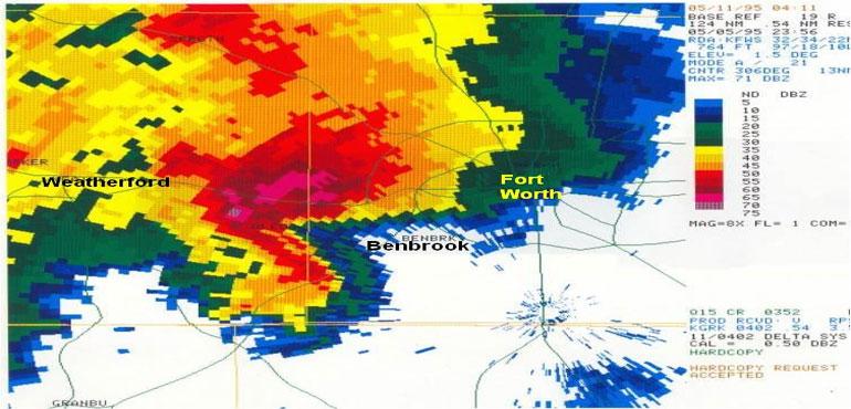
Story Image: Radar imagery from 6:56pm shows a close-up of the Mayfest supercell centered west of Benbrook. The pink and darkest red colors represent radar indications of large hail with this storm. The storm impacted the Mayfest festival at 7:10pm. (NWS Fort Worth/Dallas)
The Fort Worth region was in the crosshairs of these deadly storms during the afternoon on May 5, 1995. It all started from a cluster of storms that energized from the tropical moisture often found across the south. Strong updrafts and wind shear would help to create these powerful storms which led to a bow echo readily seen on radar at the time, indicative of a supercell thunderstorm.
With very little warning, the Fort Worth region was blasted by these robust thunderstorms. Hail up to the size of 4 inches (grapefruit size) pummeled the city. The massive hail paired with gusty winds over 57 mph and rain rates more than 2 inches left a trail of destruction. In fact, this weather event eclipsed a town event known as Mayfest and leading to more deadly outcomes.
Without proper protection, the town was fell victim to this devastating supercell. More than 400 people were injured with 60 to 100 people having to be hospitalized due to injuries sustained from the storm. Sadly, heavy rain resulting in flooding and lightning strikes led to 16 people losing their lives. Not only that, but multiple cars, homes and businesses were damaged as the storm ripped through the city. Over 55,000 people lost power and damages were said to be over $2 billion.
Due to the rapid development of this storm, this is believed to be the main reasons for the deadly outcome. Technology was less advanced at the time, so citizens not near a television or radio had no prior knowledge of the incoming storms. The good news, this unfortunate event helped to streamline a volunteer alert service known as the Radio Amateur Civil Emergency Service (RACES) and an official forecasting center for the Mayfest event to prevent this from happening in the future.
Source(s): National Weather Service (NWS)
Story Image: Radar imagery from 6:56pm shows a close-up of the Mayfest supercell centered west of Benbrook. The pink and darkest red colors represent radar indications of large hail with this storm. The storm impacted the Mayfest festival at 7:10pm. (NWS Fort Worth/Dallas)