Back to forecast
On This Day in 2005: Record-Setting Hurricane Wilma Forms
October 17, 2023 at 03:54 PM EDT
By WeatherBug Meteorologist, Matt Mehallow
The 2005 Atlantic hurricane season was record breaking, partly because of Hurricane Wilma that formed during the third week of October.
Wilma was a classic October hurricane since it formed from a tropical disturbance located southwest of Jamaica, which is a typical source region for October tropical cyclones. During the afternoon of October 15, a tropical depression formed and then meandered slowly in the waters between Jamaica and Central America.
The depression strengthened into a tropical storm on October 17, then strengthened into a hurricane the next day. Wilma rapidly intensified into a Category 5 hurricane in just a 24 hour period, with winds of 175 mph. Wilma strengthened further on October 19, reaching its peak winds of 185 mph when its minimum central pressure fell to 882 millibars, the lowest pressure ever measured in an Atlantic hurricane.
Hurricane Wilma weakened to a Category 4 storm as it neared the coast of Mexico’s Yucatán Peninsula on October 20. By October 21, Wilma made landfall on the island of Cozumel with sustained winds of 150 mph. Strong winds, heavy rains and a powerful storm surge battered the Yucatan Peninsula.
After weakening over land, Wilma exited off the northeast coast of the Yucatan Peninsula late on October 22 and headed northeast across the southern Gulf of Mexico. Favorable conditions and warm waters allowed Hurricane Wilma to strengthen back into a Category 3 hurricane again, with winds reaching 125 mph. The hurricane made landfall as a Category 3 storm with sustained winds of 120 mph on the morning of October 24 on the southwest Florida coast between Everglades City and Cape Romano.
After landfall, weakened Wilma quickly crossed the Florida Peninsula and then emerged over the western Atlantic Ocean. Hurricane Wilma strengthened again into a Category 3 hurricane the night of October 25. From there, Wilma moved quickly to the northeast and became extratropical as it passed Nova Scotia, Canada, on October 26.
Hurricane Wilma impacted southeast Florida, including the Florida Keys, with a storm surge of 4 to 8 feet, peaking at nearly 9 feet in Marathon, Fla. Approximately 3.2 million people in Florida lost electricity due to Wilma. Florida Power and Light (FPL) reported around 12,400 poles were damaged and 241 substations were de-energized. It took five days to get all the substations back online and 18 days to restore power to all FPL customers.
Hurricane Wilma also caused extensive damage to the state's citrus crop. According to estimates, Wilma knocked 17 percent of citrus crops off trees, resulting in a loss of millions of dollars worth of fruit. Damages totaled $19 billion, making Hurricane Wilma among the costliest storms in United States history.
The deaths of 52 people can be directly attributed to Hurricane Wilma, with 30 occurring in the United States and 12 in Haiti.
Sources: NHC, NWS
----------
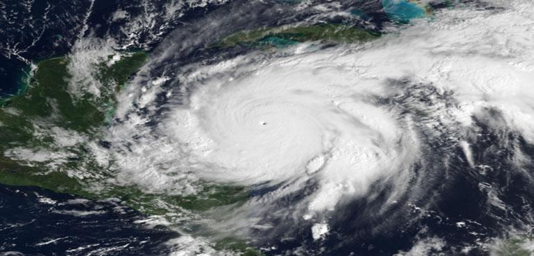
Story Image: Composite image of Hurricane Wilma superimposing a visible satellite image of Wilma from GOES-12 taken at 13:45 UTC on October 19 (data from NOAA CLASS) and the October Blue Marble Next Generation data derived from MODIS imagery. Courtesy of Wikimedia Commons
Wilma was a classic October hurricane since it formed from a tropical disturbance located southwest of Jamaica, which is a typical source region for October tropical cyclones. During the afternoon of October 15, a tropical depression formed and then meandered slowly in the waters between Jamaica and Central America.
The depression strengthened into a tropical storm on October 17, then strengthened into a hurricane the next day. Wilma rapidly intensified into a Category 5 hurricane in just a 24 hour period, with winds of 175 mph. Wilma strengthened further on October 19, reaching its peak winds of 185 mph when its minimum central pressure fell to 882 millibars, the lowest pressure ever measured in an Atlantic hurricane.
Hurricane Wilma weakened to a Category 4 storm as it neared the coast of Mexico’s Yucatán Peninsula on October 20. By October 21, Wilma made landfall on the island of Cozumel with sustained winds of 150 mph. Strong winds, heavy rains and a powerful storm surge battered the Yucatan Peninsula.
After weakening over land, Wilma exited off the northeast coast of the Yucatan Peninsula late on October 22 and headed northeast across the southern Gulf of Mexico. Favorable conditions and warm waters allowed Hurricane Wilma to strengthen back into a Category 3 hurricane again, with winds reaching 125 mph. The hurricane made landfall as a Category 3 storm with sustained winds of 120 mph on the morning of October 24 on the southwest Florida coast between Everglades City and Cape Romano.
After landfall, weakened Wilma quickly crossed the Florida Peninsula and then emerged over the western Atlantic Ocean. Hurricane Wilma strengthened again into a Category 3 hurricane the night of October 25. From there, Wilma moved quickly to the northeast and became extratropical as it passed Nova Scotia, Canada, on October 26.
Hurricane Wilma impacted southeast Florida, including the Florida Keys, with a storm surge of 4 to 8 feet, peaking at nearly 9 feet in Marathon, Fla. Approximately 3.2 million people in Florida lost electricity due to Wilma. Florida Power and Light (FPL) reported around 12,400 poles were damaged and 241 substations were de-energized. It took five days to get all the substations back online and 18 days to restore power to all FPL customers.
Hurricane Wilma also caused extensive damage to the state's citrus crop. According to estimates, Wilma knocked 17 percent of citrus crops off trees, resulting in a loss of millions of dollars worth of fruit. Damages totaled $19 billion, making Hurricane Wilma among the costliest storms in United States history.
The deaths of 52 people can be directly attributed to Hurricane Wilma, with 30 occurring in the United States and 12 in Haiti.
Sources: NHC, NWS
----------
Story Image: Composite image of Hurricane Wilma superimposing a visible satellite image of Wilma from GOES-12 taken at 13:45 UTC on October 19 (data from NOAA CLASS) and the October Blue Marble Next Generation data derived from MODIS imagery. Courtesy of Wikimedia Commons