Back to forecast
On This Day in 2012: Destructive Hurricane Sandy Slams Eastern US
October 29, 2021 at 04:28 AM EDT
By WeatherBug Meteorologist, Anthony Sagliani
On this date in 2012, one of the great storms of eastern U.S. history barreled into the coast of New Jersey.
Commonly referred to as Superstorm Sandy, this system was ultimately responsible for the deaths of 233 people and nearly $70 billion in damage from the Caribbean to Canada. At its peak, 8.7 million homes and businesses were without electricity across 20 states and the District of Columbia.
Sandy’s roots can be traced back to a tropical wave in the western Caribbean Sea that quickly organized into a tropical storm on October 22, 2012. Sandy gradually intensified through the next 48 hours and became a hurricane on October 24 before making landfall in Jamaica. Sandy then strengthened further and became a Category 3 major hurricane as it made landfall in Cuba on October 25.
From that point on, an exceptionally rare series of meteorological events occurring perhaps only once every 50-100 years allowed Sandy to grow into immense size as the storm curved left toward the Northeast U.S. coastline.
Although Sandy made landfall on the coast of New Jersey with sustained wind of 80 mph, the impacts of this storm extended well beyond. All told, storm surge flooding and strong winds destroyed as many as 600,000 housing units across New Jersey and New York. Flooding in New York City was so severe that tunnels, subways, and streets experienced record high waters. Electricity was cut off to a large part of the city at times.
Further south across Maryland, Virginia, and West Virginia, 5 to 10 inches of rain resulted in widespread flooding while strong winds knocked out power to hundreds of thousands. The higher elevations of western Pennsylvania, western Maryland, and West Virginia also saw blizzard conditions with more than 1 to 2 feet of snow.
While Sandy was exceptionally damaging, many people understood it was coming. Computer forecast models began hinting at a historic weather event occurring as many as 6 or 7 days in advance. Preparations and evacuations occurred long before the storm’s arrival.
Overall, Sandy is tied with Hurricane Ida for the 4th costliest storm in United States history, falling only behind Hurricane Katrina, Hurricane Harvey and Hurricane Maria. This storm will not soon be forgotten by anyone who lived through it.
Sources: NOAA, NWS, NASA, FEMA, NESDIS
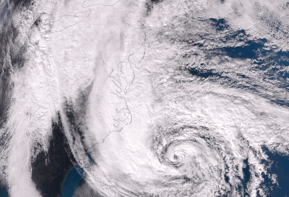
Story Image: The Visible Infrared Imaging Radiometer Suite (VIIRS) on the Suomi NPP satellite acquired this natural-color image of Hurricane Sandy at 1:50 p.m. Eastern Daylight Time (17:50 Universal Time) on October 28, 2012.
Commonly referred to as Superstorm Sandy, this system was ultimately responsible for the deaths of 233 people and nearly $70 billion in damage from the Caribbean to Canada. At its peak, 8.7 million homes and businesses were without electricity across 20 states and the District of Columbia.
Sandy’s roots can be traced back to a tropical wave in the western Caribbean Sea that quickly organized into a tropical storm on October 22, 2012. Sandy gradually intensified through the next 48 hours and became a hurricane on October 24 before making landfall in Jamaica. Sandy then strengthened further and became a Category 3 major hurricane as it made landfall in Cuba on October 25.
From that point on, an exceptionally rare series of meteorological events occurring perhaps only once every 50-100 years allowed Sandy to grow into immense size as the storm curved left toward the Northeast U.S. coastline.
Although Sandy made landfall on the coast of New Jersey with sustained wind of 80 mph, the impacts of this storm extended well beyond. All told, storm surge flooding and strong winds destroyed as many as 600,000 housing units across New Jersey and New York. Flooding in New York City was so severe that tunnels, subways, and streets experienced record high waters. Electricity was cut off to a large part of the city at times.
Further south across Maryland, Virginia, and West Virginia, 5 to 10 inches of rain resulted in widespread flooding while strong winds knocked out power to hundreds of thousands. The higher elevations of western Pennsylvania, western Maryland, and West Virginia also saw blizzard conditions with more than 1 to 2 feet of snow.
While Sandy was exceptionally damaging, many people understood it was coming. Computer forecast models began hinting at a historic weather event occurring as many as 6 or 7 days in advance. Preparations and evacuations occurred long before the storm’s arrival.
Overall, Sandy is tied with Hurricane Ida for the 4th costliest storm in United States history, falling only behind Hurricane Katrina, Hurricane Harvey and Hurricane Maria. This storm will not soon be forgotten by anyone who lived through it.
Sources: NOAA, NWS, NASA, FEMA, NESDIS
Story Image: The Visible Infrared Imaging Radiometer Suite (VIIRS) on the Suomi NPP satellite acquired this natural-color image of Hurricane Sandy at 1:50 p.m. Eastern Daylight Time (17:50 Universal Time) on October 28, 2012.