Back to forecast
On This Day in 2022: The Great Lakes, Midwest Derecho
June 13, 2023 at 12:12 AM EDT
By WeatherBug Meteorologist, Matt Mehallow
On this day one year ago, a powerful derecho caused widespread destruction from the Upper Midwest into the lower Great Lakes and Ohio Valley.
Starting Monday afternoon on June 13, a warm front divided extremely hot and humid conditions to the southwest from cooler and drier conditions to the northeast. This warm front that was draped across northern Illinois to northern Indiana and northern Ohio became stationary and lingered through the late evening on June 13.
Very warm and humid conditions led to extreme instability during the afternoon, which provided plenty of fuel for storms along and south of the warm front. The addition of abundant moisture along the front favored the development of strong storms and heavy rain. There was also sufficient wind shear aloft for the organization of the storms. Since the environment was primed for severe storms when an upper level disturbance pushed into the area, this acted as a trigger for the generation of severe storms to sustain themselves through the evening and into the early morning on June 14.
Severe storms that originated in southern Wisconsin and northeast Illinois blasted their way through southern Michigan into northern Indiana and northern Ohio, wreaking havoc during the afternoon and evening. These severe storms continued into the overnight hours, resulting in a significant swath of straight line wind damage.
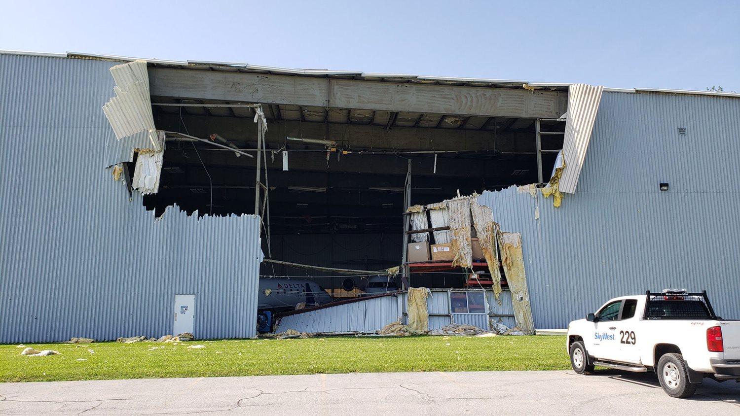
At the Fort Wayne Airport in Indiana, a wind gust of 98 mph from a severe storm was recorded. This led to significant damage in the Fort Wayne area. This was the strongest wind gust ever recorded at the Fort Wayne International Airport. The previous record was 91 mph on June 30th, 2012. There many other wind measurements ranging from 50 to 75 mph.
The intense storms rumbled through north central and northeast Ohio as well, producing significant wind damage, with gusts reaching 60 to 70 mph in northwest Ohio. Winds as high as 80 mph led to tree damage in north-central Ohio. Wooster Township through Millersburg, Ohio, even saw. winds reach estimated speeds of 80 mph to over 90 mph due to a macroburst that moved over the area.
Thousands of trees were uprooted along the path of the strong winds, with many of the trees hitting houses, cars, and electricity wires, leading to extensive power outages.
In addition to the straight line winds, an EF-0 tornado touched down in Schaumburg, Illinois, and three EF-1 tornadoes occurred in Ohio. Several barns and outbuildings were damaged or destroyed by these tornadoes.
Sources: spc.noaa.gov, weather.gov, ncdc.noaa.gov
----------
Story Image: Damage at the KFWA SkyWest Terminal (Emily Dwire - WANE 15 via NWS Northern Indiana)
Starting Monday afternoon on June 13, a warm front divided extremely hot and humid conditions to the southwest from cooler and drier conditions to the northeast. This warm front that was draped across northern Illinois to northern Indiana and northern Ohio became stationary and lingered through the late evening on June 13.
Very warm and humid conditions led to extreme instability during the afternoon, which provided plenty of fuel for storms along and south of the warm front. The addition of abundant moisture along the front favored the development of strong storms and heavy rain. There was also sufficient wind shear aloft for the organization of the storms. Since the environment was primed for severe storms when an upper level disturbance pushed into the area, this acted as a trigger for the generation of severe storms to sustain themselves through the evening and into the early morning on June 14.
Severe storms that originated in southern Wisconsin and northeast Illinois blasted their way through southern Michigan into northern Indiana and northern Ohio, wreaking havoc during the afternoon and evening. These severe storms continued into the overnight hours, resulting in a significant swath of straight line wind damage.
At the Fort Wayne Airport in Indiana, a wind gust of 98 mph from a severe storm was recorded. This led to significant damage in the Fort Wayne area. This was the strongest wind gust ever recorded at the Fort Wayne International Airport. The previous record was 91 mph on June 30th, 2012. There many other wind measurements ranging from 50 to 75 mph.
The intense storms rumbled through north central and northeast Ohio as well, producing significant wind damage, with gusts reaching 60 to 70 mph in northwest Ohio. Winds as high as 80 mph led to tree damage in north-central Ohio. Wooster Township through Millersburg, Ohio, even saw. winds reach estimated speeds of 80 mph to over 90 mph due to a macroburst that moved over the area.
Thousands of trees were uprooted along the path of the strong winds, with many of the trees hitting houses, cars, and electricity wires, leading to extensive power outages.
In addition to the straight line winds, an EF-0 tornado touched down in Schaumburg, Illinois, and three EF-1 tornadoes occurred in Ohio. Several barns and outbuildings were damaged or destroyed by these tornadoes.
Sources: spc.noaa.gov, weather.gov, ncdc.noaa.gov
----------
Story Image: Damage at the KFWA SkyWest Terminal (Emily Dwire - WANE 15 via NWS Northern Indiana)