Back to forecast
Pacific Storm System Set To Deliver Winter Weather
November 10, 2021 at 12:53 PM EST
UPDATED By WeatherBug Meteorologists
A Pacific storm system will advance east over the next several days, bringing unsettled weather to much of the U.S. Hazards including locally heavy rain, snow, high winds and even a few severe thunderstorms as the expansive storm system pinwheels across the country.
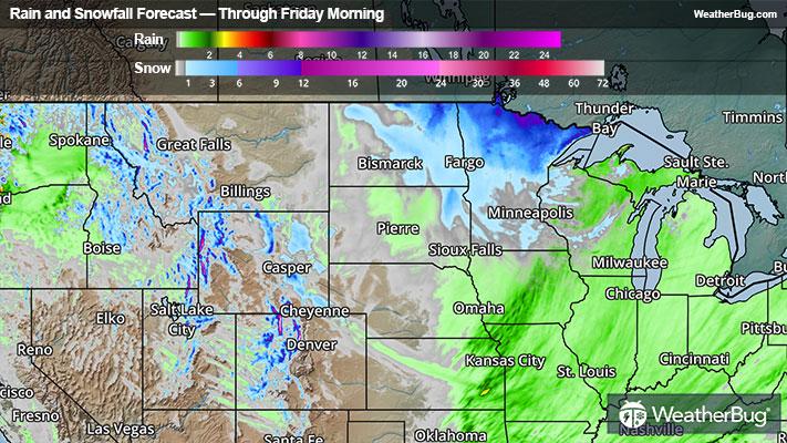
An upper-level weather system and associated cold front will cross the Rocky Mountains and move into the Plains today. Once it gets to the nation’s midsection later today and Thursday, the weather system will deepen and expand as far south as the southern Plains and Lower Mississippi Valley. The strong storm system will then rotate across the Great Lakes on Friday, sending the powerful cold front across the Eastern Seaboard.
Light snow will likely continue for most of the day in the northern and central Rockies, where Winter Weather Advisories are scattered throughout Idaho, Montana, Wyoming and northwestern Colorado.
Rain and a few thunderstorms will become increasingly likely across the Plains and Mississippi Valley today into Thursday morning, with wet, heavy snow developing by Thursday morning over the north-central U.S. Locally heavy rain is possible into Thursday, especially within thunderstorms over the southern Plains and Middle Mississippi Valley. The combination of heavy rain and fallen leaves could cause urban flooding as leaf debris could clog storm drains.
Snowfall amounts could range from a Trace to several inches across the Dakotas and Minnesota, with the highest amounts expected along the Canadian border. A Winter Storm Watch has been issued for northeastern South Dakota, where high winds and snow of 2 to 4 inches could create near blizzard conditions.
A few strong to severe thunderstorms could also develop across the southern Plains late this afternoon and into early Thursday morning as the cold front advances across Oklahoma and northern Texas. The Storm Prediction Center has issued a Slight Risk of severe thunderstorms along the Red River and into central Oklahoma. Cities including Plano and Denton Texas, and Oklahoma City will have to keep a watchful eye on the sky tonight as storms could produce damaging wind gusts, large hail and even an isolated tornado.
As if dodging heavy rain, snow and strong to severe weather was not enough, winds will become quite strong as the system begins to strengthen later today into Thursday. Peak wind gusts of 35 to 45 mph are likely across the Dakotas to Minnesota from today through Friday evening. Wind Advisories have been hoisted in western South Dakota while High Wind Warnings have been issued in southern Wyoming and north-central Nebraska where gusts up to 55 mph are possible. Additional wind advisories will likely be issued across parts of the northern Plains and Great Lakes today and Thursday. Strong winds combined with snow across Minnesota and North Dakota will lead to reduced visibility and hazardous travel conditions.
Whatever the case may be, it is never too early to have a supply kit packed in case of inclement weather. A simple kit including a weather radio, water, blankets, batteries, and non-perishable food items will go a long way in the event of a power outage. It’s always best to not travel in rough weather as the roads will be dangerous. Make sure to download the WeatherBug app to stay up to date on the latest.