


Plethora of Severe Threats Target Central U.S. and Carolinas
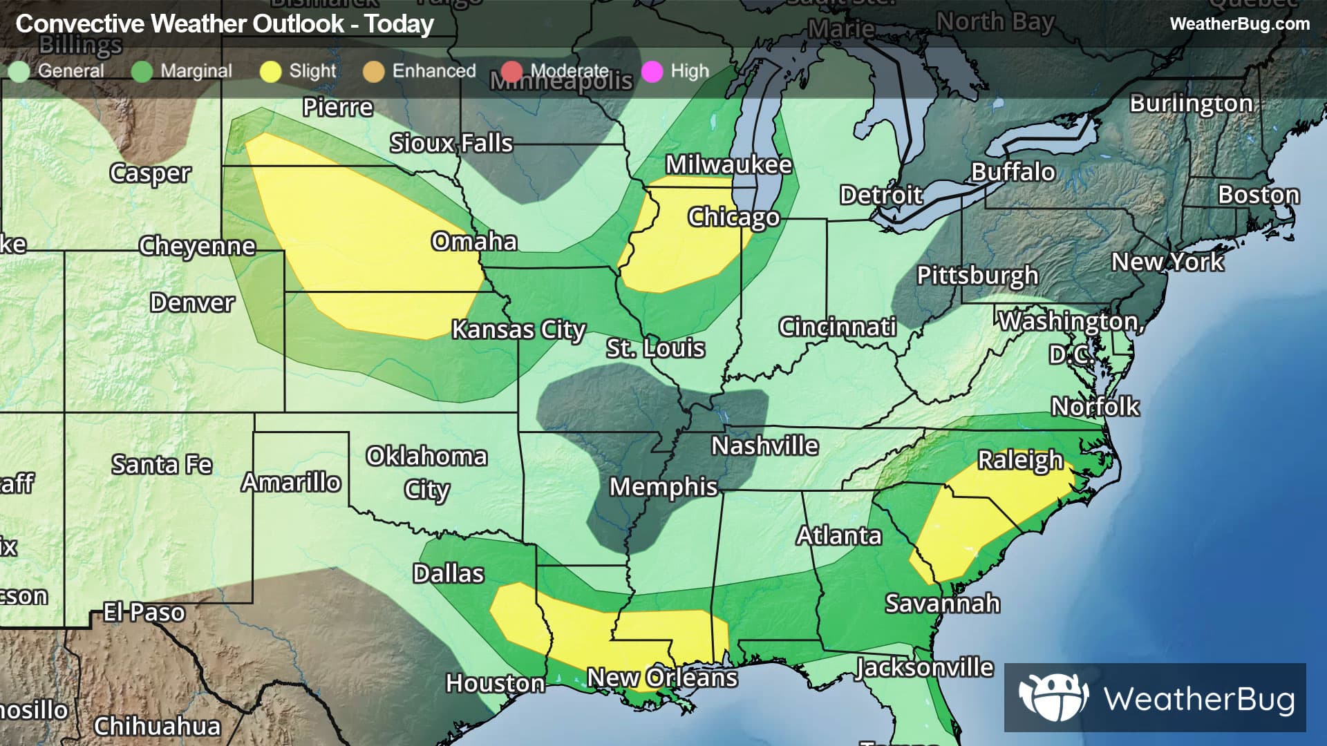
The central U.S. and the Carolinas continue to be the main focus for severe weather today.
An approaching cold front will trigger thunderstorms across the central U.S. this afternoon into the late evening hours. In addition, strong winds aloft and moderate instability will be present, leading to severe weather development today.
The government's Storm Prediction Center has posted a Slight Risk, a 2 out of 5 on the severe weather probability scale, for most of Nebraska and north-central Kansas. This includes Lincoln, Valentine, North Platte, McCook and Grand Island, Neb. and Manhattan, Phillipsburg and Salina, Kan. The main concerns will be hail larger than hen eggs as well as wind gusts exceeding 65 mph.
A Severe Thunderstorm Watch has been issued for western Nebraska.
In addition, portions of the Midwest will see severe weather potential as well. This is largely due to ample moisture, the approaching cold front and moderate instability.
There is another Slight Risk for far eastern Iowa, far northwestern Indiana, southeastern Wisconsin and northern and central Illinois. This includes Gary, Ind., Madison, Milwaukee and Kenosha, Wis., Davenport, Iowa and Moline, Peoria, Joliet, Rockford and Chicago, Ill. Hail larger than quarters, gusts exceeding 60 mph and isolated tornadoes will be the main threats.
Here, a Severe Thunderstorm Watch stretches from extreme eastern Iowa across southern Wisconsin and northern Illinois, including the Chicago metro area.
Further east in the Carolinas, a weak cold front will help trigger afternoon and evening thunderstorms. Plentiful moisture and warm temperatures as well as moderate instability will aid in severe weather development.
A third Slight Risk is in place for far east-central Georgia, central and eastern North Carolina and central South Carolina. This includes Charlotte, Raleigh and Fayetteville, N.C., Columbia and Florence, S.C. and Augusta, Ga. Hail larger than quarters and gusts exceeding 60 mph will be the primary concerns.
A Severe Thunderstorm Watch extends from southeastern South Carolina to central North Carolina, including Myrtle Beach and Columbia, S.C., and Wilmington and Charlotte, N.C.
In addition, central North Carolina will see excessive rain throughout the afternoon and evening. Rain totals of 2 to 4 inches with localized amounts up to 5 inches will be possible along with heavy rain rates. These rates and totals may lead to flooding in poor drainage and urban areas along with rivers and streams. Flood Watches have been posted for central North Carolina, including Raleigh, Asheboro and Fayetteville. Remember, when facing flooded roadways, "Turn Around, Don't Drown!"
A fourth Slight Risk area is in place across parts of eastern Texas, Louisiana, southern Mississippi, and southwestern Alabama. Cities such as Lufkin, Texas, New Orleans, and Mobile, Ala. are included in this area.
Severe Thunderstorm Watches are in place from eastern Texas to the extreme western Florida Panhandle, including Mobile, Ala., Baton Rouge, La., and Lufkin, Texas.
Be sure to know the difference between a watch and a warning. A watch means that the conditions are in place to possibly produce severe weather, while a warning indicates that those conditions are currently occurring. Be sure to have multiple ways to receive warnings, as storms will be occurring late tonight. Also, take caution if you are outdoors during a thunderstorm. Remember, “When Thunder Roars, Go Indoors!”