


Potent Storms Target N. Plains, Southwest & New England
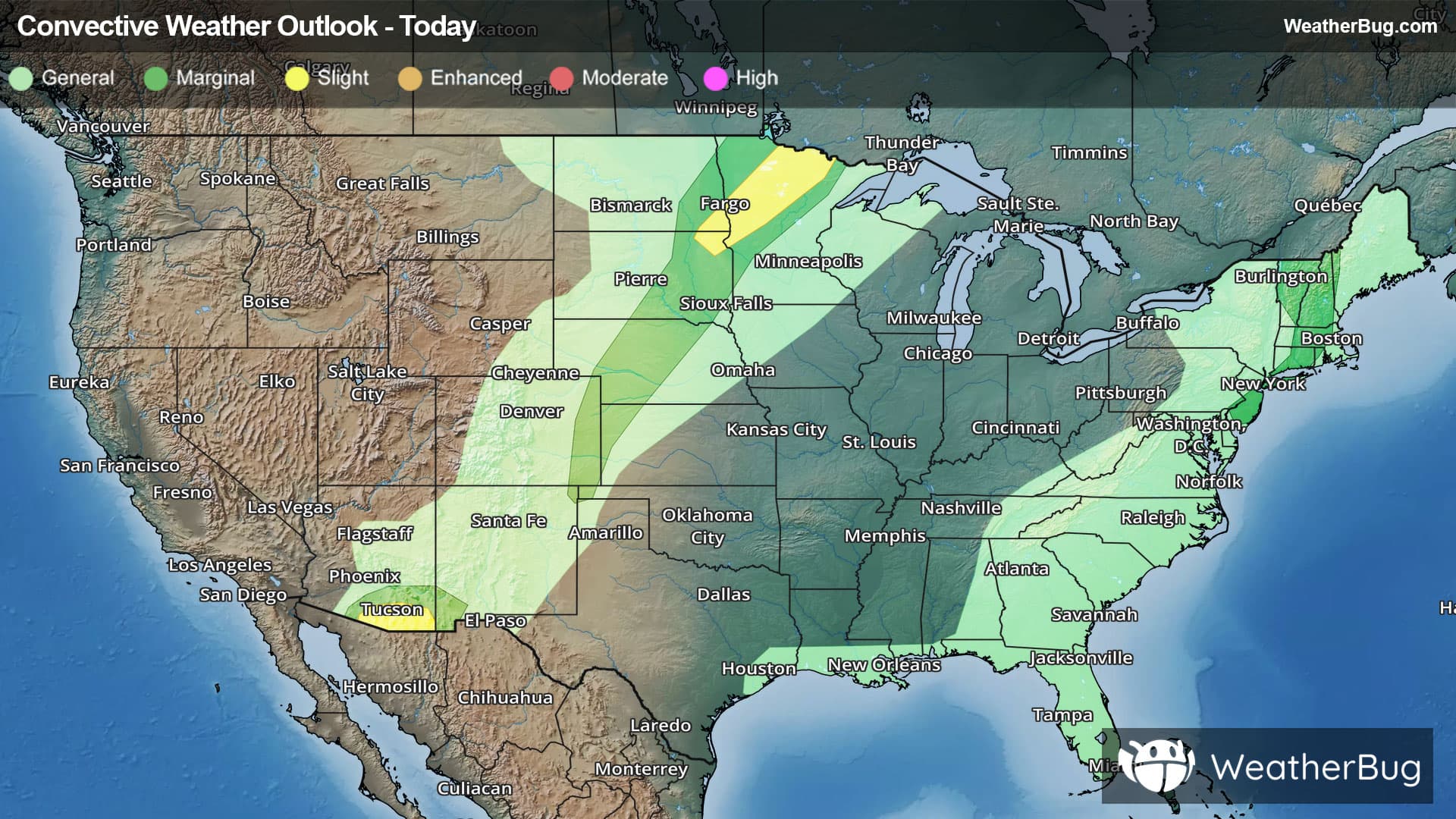
Multiple cold fronts and monsoonal moisture will lead to several rounds of strong to severe thunderstorms today. Areas at risk include the Southwest, northern Plains and New England.
The best chance of severe weather today will be found in the northern Plains as a cold front drops south out of Canada. Very warm and humid air will be in place ahead of the cold front, while colder, drier air attempts to filter in behind the cold front. This collision of air masses will be where thunderstorms pop up this afternoon and evening.
The government’s Storm Prediction Center has issued a Slight Risk (level 2 out of 5) for severe weather across far southeastern North Dakota and northeastern South Dakota into northern Minnesota. This includes Fargo, N.D., and Bemidji, Minn. Within thunderstorms, the main concerns will be damaging winds, large hail and torrential downpours. An isolated tornado or two also cannot be ruled out.
Meanwhile, monsoonal moisture will be flowing into the Southwest today. With plenty of moisture and heat, thunderstorms will fire up across the Four Corners states this afternoon and evening.
A Slight Risk (level 2 out of 5) for severe weather across southeastern Arizona, including Tucson. The main concern within thunderstorms will be strong winds and heavy rains. Though, some large hail will also be a possibility.
As if that wasn’t enough, a cold front will be stalled along the Eastern Seaboard. Thunderstorms will be likely throughout the East as a result. Plenty of instability, moisture and warm, humid air could cause thunderstorms to strengthen and potentially become severe across parts of the Northeast.
There is a Marginal Risk (level 1 out of 5) in effect for most of Vermont, New Hampshire, most of Massachusetts, Connecticut and Rhode Island into southeastern New York, Long Island and the southern half of New Jersey. Heavy to very heavy rain and gusty winds will likely be associated with thunderstorms that develop here. Cities within this Marginal Risk include Burlington, Vt., Concord, N.H., Worcester and Springfield, Mass., New York City, Philadelphia and Atlantic City, N.J.
Both cold fronts and another surge of cold fronts will be in play on Tuesday. However, they begin to lose their punch, which will cause severe weather chances to drop significantly compared to today.
Be sure to know the difference between a watch and a warning. A watch means that the conditions are in place to possibly produce severe weather conditions, while a warning indicates that those conditions are currently occurring. Be sure to have multiple ways to receive warnings as storms will be occurring late tonight. Also, take caution if you are outdoors during a thunderstorm. Remember, “When Thunder Roars, Go Indoors!”