Powerful Thunderstorms Target Lower Midwest
Intense severe thunderstorms will surge into the Lower Midwest and Mid-South today, bringing damaging winds, large hail, and tornadic activity.
Already, a few severe thunderstorm clusters from Sunday continue to thrive in the central Plains this morning.
A Severe Thunderstorm Watch has been issued for west-central Missouri and east-central Kansas. Damaging winds, large hail, and bouts of heavy rain with low visibility are all possible within a severe thunderstorm. Cities such as Emporia and Topeka, Kan., as well as St. Joseph and Kansas City, Mo., are all within this watch.
The main instigator is a new low pressure system in the Plains, hitching a northward ride on the jet stream. Along its path, a dry and cold air mass from the northern Plains is currently rushing to replace torrid air bubbling into the Lower Midwest and Mid-South. Unfortunately, as these factors synergize to intensify the storm system, impacts on the ground will escalate, with multiple rounds of severe thunderstorms likely.
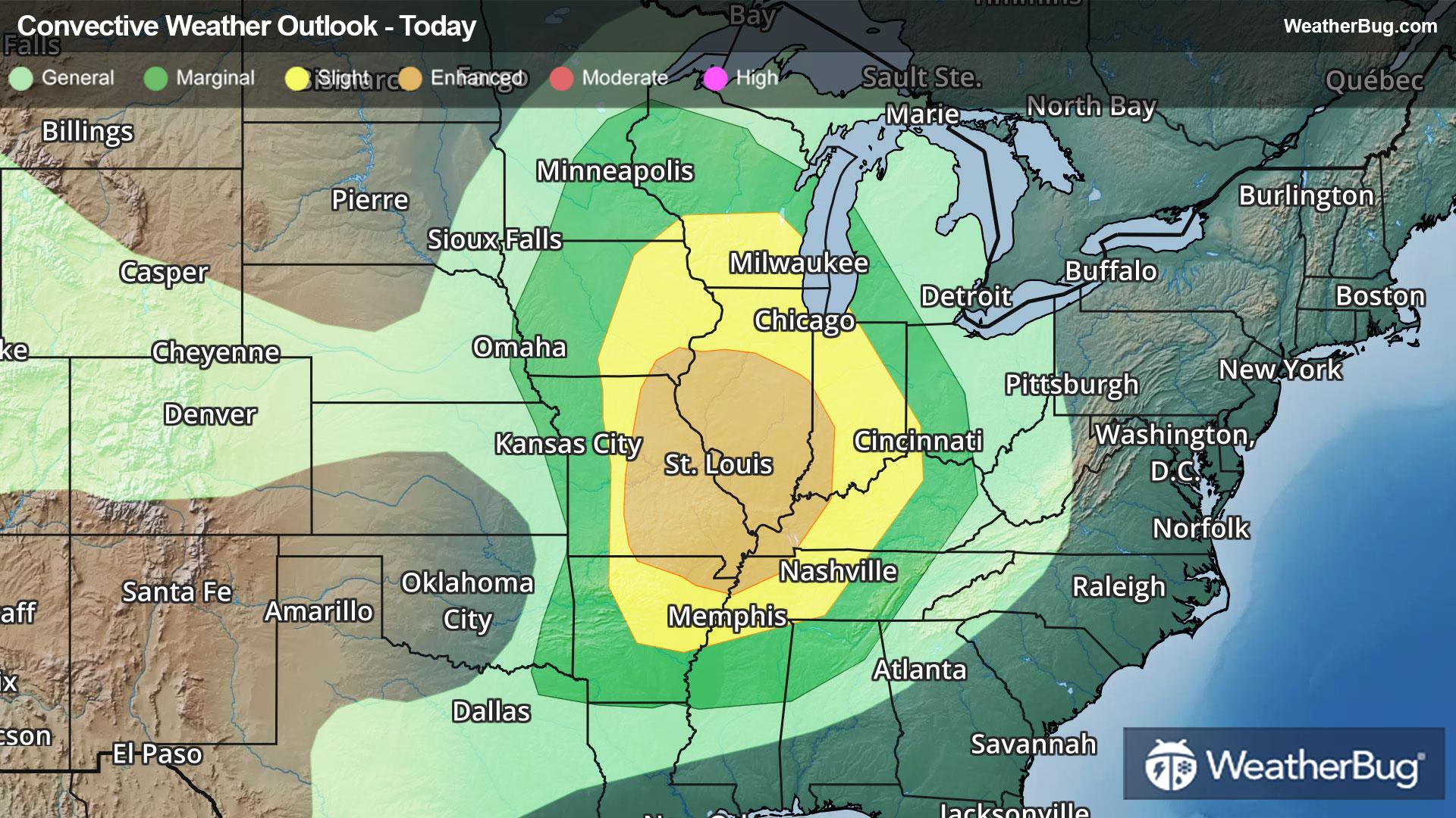
The Storm Prediction Center currently holds an Enhanced Risk, or a 3 out of 5 on the severe weather probability scale, for central and southern Illinois, eastern Missouri, and small portions of Iowa, Arkansas, Kentucky, Indiana, and Tennessee. Folks in metropolitan areas such as Springfield, Ill., St. Louis and Columbia, Mo., Burlington, Iowa, and Evansville, Ind., are at risk for scattered to numerous damaging wind gusts, widely scattered hailstorms with hail up to 2 inches in diameter, and isolated, strong tornadoes.
An encompassing Slight Risk, or a 2 out of 5 on the severe weather probability scale, surrounds the core of severe concerns today. Although likely to see lesser coverage and intensity from severe thunderstorms, cities including Chicago, Indianapolis, Milwaukee, Louisville, Ky., Memphis and Nashville, Tenn., and Cincinnati, Ohio, are still threatened beneath this risk region.
Heavy rain under intense thunderstorms will also bring flooding concerns to the Lower Midwest and Mid-South. A Flood Watch has been posted for northwestern Missouri and its neighboring counties.
Rain totals of one to two inches will be common today, with localized totals of three to four inches possible beneath consecutive thunderstorm tracks. Be weather-aware in low-lying and urban areas, and remember, “Turn Around, Don’t Drown!”
On Tuesday, a new low pressure center will form in the southern Plains, causing the initial cold front to halt just north of the Mid-South. Here, humid and unstable air awaits ignition into widely scattered severe thunderstorms, likely developing into thunderstorm clusters as they track eastward.
A Slight Risk has been issued for a large swath of the Mid-South, covering areas from southwestern Kentucky and far southern Missouri into northeastern Texas and northwestern Alabama. Isolated intense hailstorms and tornadoes alongside widely scattered damaging winds are expected to form, threatening cities such as Dallas and Plano, Texas, Little Rock, Ark., Memphis and Nashville, Tenn., Shreveport and Monroe, La., Jackson, Miss., and Birmingham and Huntsville, Ala.
Isolated severe storms may convene within the western Gulf states and Lower Mid-Atlantic on Wednesday, ahead of the second system’s cold front as it dives southeastward.
Make sure to know the difference between a watch and a warning should they be issued. A "watch" means that conditions are favorable for severe weather to occur, and to be on alert for any rapidly changing conditions. A "warning" means that severe weather is imminent, and you should act fast to remain safe.
The best way to remain safe is to stay prepared and informed about your local weather. Have a severe weather kit packed with a battery-operated radio, water, and non-perishable food items. Also, check the WeatherBug app frequently for any updates on today's severe weather. Remember, "When Thunder Roars, Go Indoors!"