Back to forecast
Powerful Winter Storm Targets Ireland, Britain
January 24, 2025 at 03:57 AM EST
UPDATED by WeatherBug Meteorologist, Andrew Rosenthal
A powerful winter storm is headed for the British Isles and Scandinavia today and Saturday and promises to bring damaging winds.
The storm, named Éowyn (pronounced “Ay-oh-win”) by the United Kingdom’s MetOffice, is of equivalent strength to a Category 3 of 4 hurricane on the Saffir-Simpson Hurricane Wind Scale as it quickly moves across the Atlantic. Its origins were in the same area of low pressure that brought 6 to 10 inches of snow to the Gulf Coast earlier this week. Since then, it has been the focal point for a battleground between the Arctic airmass that plagued the U.S. and the warmer waters of the Atlantic, which has allowed the storm to strengthen.
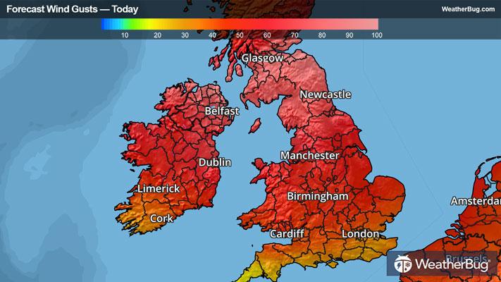
Éowyn is expected to start moving into Ireland early this morning, with wind gusts as high as 100 to 110 mph (150 to 170 km/h) possible along the western Irish coastline. The low pressure system itself will travel northeastward today, reserving the brunt of its wind for the west coast from Dingle to Belmullet. However, all of Ireland will likely see gusts of 50 to 70 mph (90 to 110 km/h) today, which will likely lead to wind damage and power outages across the island.
In fact, a wind gust of 114 mph (183 km/h) was reported at Mace Head Co, Galway, Ireland at 5 AM local time this morning. If verified, this would be the strongest wind gusts ever recorded in Ireland.
The storm is strong enough that NOAA has deployed one of their hurricane hunter aircrafts to Shannon, Ireland, to provide storm reconnaissance information – the first time in nearly eight years that the aircraft has been sent to Europe.
Éowyn will maintain its strengthen as it scrapes along the northern fringes of Scotland while moving from the Atlantic into the northern reaches of the North Sea later today. Wind damage is likely from the Faroe Islands to the Shetlands and Scottish Mainland. This will likely bring strong winds to Scotland, including the cities of Glasgow and Edinburgh, this afternoon and evening. Additionally, there is the potential for 6 to 10 inches (15 to 25 cm) of snow in areas above 1000 feet (305 meters) of elevation.
All schools across both Ireland, Northern Ireland and northern Scotland have been advised to close, and rail services cancelled ahead of the storm. Already one person has been treated for injuries sustained when violent winds associated with Éowyn tore through Cornwall in southwestern England.
The storm will likely make landfall early Saturday in central and southern Norway, bringing heavy snow and damaging winds deep into Scandinavia. Further south, its impact will be a bit more muted, with England, northern France and the Benelux likely to see wind gusts of 30 to 45 mph (60 to 80 km/h) tonight into Saturday, along with periods of rain.
The entirety of Ireland and Northern Ireland are under a top-of-the-scale Red Alert for wind gusts today, while Yellow and Amber Alerts extend through Britain.
Perhaps not surprisingly given the active weather pattern here in the U.S., western Europe won’t see much of a let-up as we work our way through the weekend. Another low pressure system with similar intensity to Éowyn will approach Ireland on Sunday and Monday. While this storm is likely to weaken before it moves ashore, its track may be more favorable to bring strong winds and rain to the populated areas of Ireland and England.
For what it’s worth, were that storm to be given a name, it would be called “Floris.” The list of names for western European storms, which changes each year, extends from Ashley to Wren this winter.
The storm, named Éowyn (pronounced “Ay-oh-win”) by the United Kingdom’s MetOffice, is of equivalent strength to a Category 3 of 4 hurricane on the Saffir-Simpson Hurricane Wind Scale as it quickly moves across the Atlantic. Its origins were in the same area of low pressure that brought 6 to 10 inches of snow to the Gulf Coast earlier this week. Since then, it has been the focal point for a battleground between the Arctic airmass that plagued the U.S. and the warmer waters of the Atlantic, which has allowed the storm to strengthen.
Éowyn is expected to start moving into Ireland early this morning, with wind gusts as high as 100 to 110 mph (150 to 170 km/h) possible along the western Irish coastline. The low pressure system itself will travel northeastward today, reserving the brunt of its wind for the west coast from Dingle to Belmullet. However, all of Ireland will likely see gusts of 50 to 70 mph (90 to 110 km/h) today, which will likely lead to wind damage and power outages across the island.
In fact, a wind gust of 114 mph (183 km/h) was reported at Mace Head Co, Galway, Ireland at 5 AM local time this morning. If verified, this would be the strongest wind gusts ever recorded in Ireland.
The storm is strong enough that NOAA has deployed one of their hurricane hunter aircrafts to Shannon, Ireland, to provide storm reconnaissance information – the first time in nearly eight years that the aircraft has been sent to Europe.
Éowyn will maintain its strengthen as it scrapes along the northern fringes of Scotland while moving from the Atlantic into the northern reaches of the North Sea later today. Wind damage is likely from the Faroe Islands to the Shetlands and Scottish Mainland. This will likely bring strong winds to Scotland, including the cities of Glasgow and Edinburgh, this afternoon and evening. Additionally, there is the potential for 6 to 10 inches (15 to 25 cm) of snow in areas above 1000 feet (305 meters) of elevation.
All schools across both Ireland, Northern Ireland and northern Scotland have been advised to close, and rail services cancelled ahead of the storm. Already one person has been treated for injuries sustained when violent winds associated with Éowyn tore through Cornwall in southwestern England.
The storm will likely make landfall early Saturday in central and southern Norway, bringing heavy snow and damaging winds deep into Scandinavia. Further south, its impact will be a bit more muted, with England, northern France and the Benelux likely to see wind gusts of 30 to 45 mph (60 to 80 km/h) tonight into Saturday, along with periods of rain.
The entirety of Ireland and Northern Ireland are under a top-of-the-scale Red Alert for wind gusts today, while Yellow and Amber Alerts extend through Britain.
Perhaps not surprisingly given the active weather pattern here in the U.S., western Europe won’t see much of a let-up as we work our way through the weekend. Another low pressure system with similar intensity to Éowyn will approach Ireland on Sunday and Monday. While this storm is likely to weaken before it moves ashore, its track may be more favorable to bring strong winds and rain to the populated areas of Ireland and England.
For what it’s worth, were that storm to be given a name, it would be called “Floris.” The list of names for western European storms, which changes each year, extends from Ashley to Wren this winter.