


September Nor'easter 2026 What We Know About the East Coast Storm
If you were hoping for a quiet ending to the month of September, you won’t be getting it.
A strong Nor’easter is taking shape off the East Coast, and it will make the last week of September a messy one from North Carolina to New England.
Typically when we start talking about Nor’easters in the fall, we’re looking at snow chances. That won’t be the case this time. The storm is only expected to produce heavy rain, persistent northeast winds, dangerous surf, beach erosion, and several rounds of coastal flooding.
The storm is expected to develop and quickly strengthen through the end of this week before arriving in the Northeast over the weekend. Some of the storm could even linger into next week.
Coastal Flooding Is the Biggest Concern
From North Carolina through Virginia, New Jersey and Long Island, the most widespread threat is coastal flooding. Some areas along the coast could see tides surge by two to three feet.
The Jersey Shore and Delaware beaches could also see quite a bit of wind. Wind speeds are expected to climb to 25-35mph with gusts over 40 mph capable of blowing unsecured items outdoors, snapping tree limbs and blowing high profile vehicles around on the road.
Those persistent winds onshore mean flooding could be a problem for everyone, even in areas where less rain is expected.
🌧️ Could the nor’easter affect your area? Track the rain, wind, timing and latest local alerts in the WeatherBug app.
New England Could See the Heaviest Rain
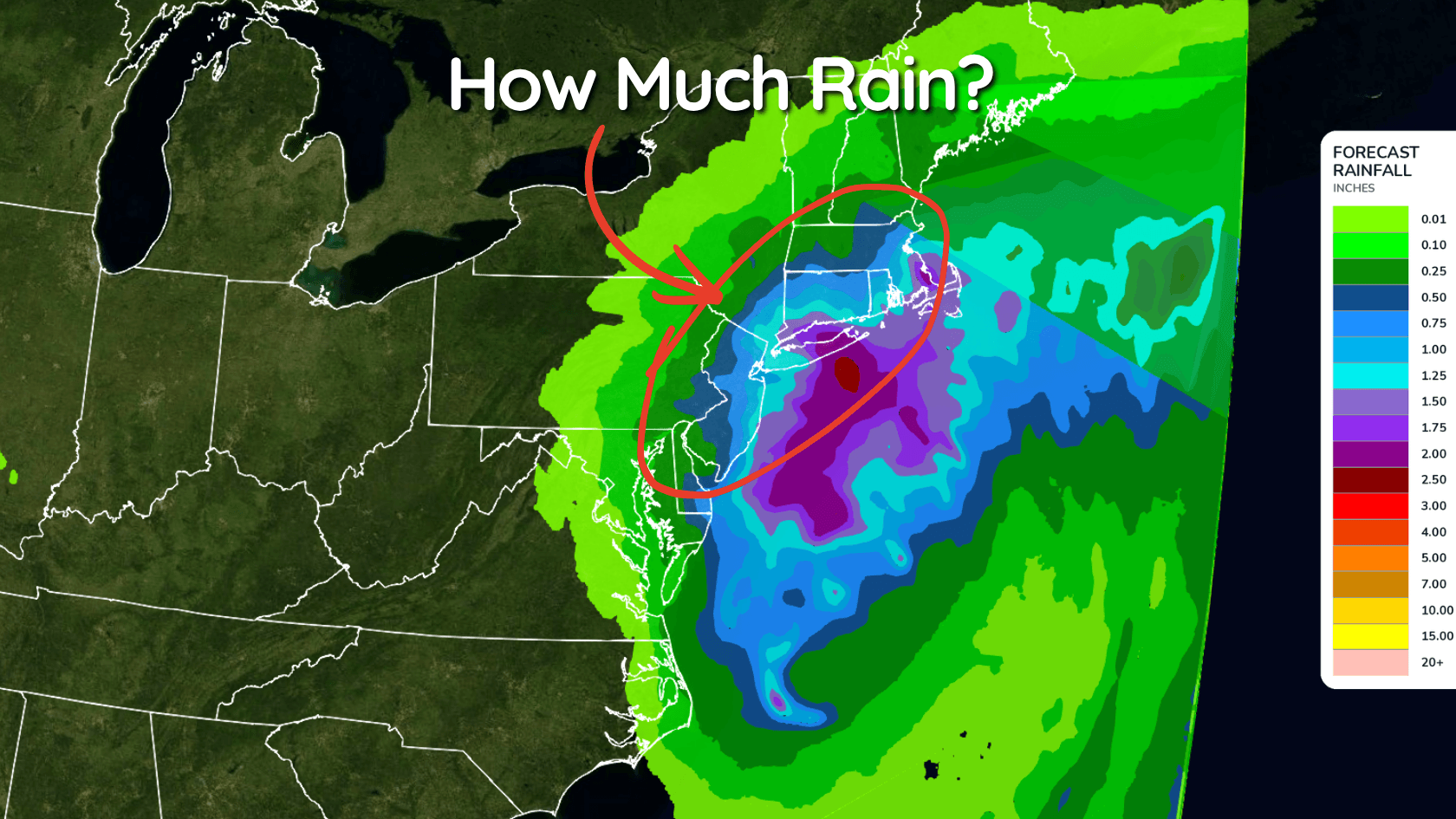
The storm’s exact track will determine how far west the heaviest rain travels, but southern New England appears most likely to receive the highest totals.
Early estimates have rainfall totals over 4 inches for coastal New England. Combine that with the winds pushing all that water onshore and it could get messy.
Rainfall impacts may be more limited around New York City and locations farther west, especially if the storm stays offshore.
Why September Leaves Could Make the Wind More Damaging
This storm is arriving before most trees have dropped their leaves.
When trees have leaves, the wind catches on them differently. High winds can do more damage to a tree that is still heavy with leaves compared to the same winds on a bare tree.
So the wind gusts may not sound impressive at the moment but right now they don't have to be impressive to do a lot of damage to trees and powerlines.
How Unusual Is a September Nor’easter?
September is early for a nor’easter, but it is not outside the normal season.
According to NOAA, nor’easters can occur at any time of year but are most common between September and April. They are generally strongest during the winter.
What makes this storm stand out is the combination of its potential strength, slow movement and arrival while trees are still fully covered in leaves.
What Is Still Uncertain?
A relatively small shift in the track could change which areas receive the heaviest rain and strongest winds. Inland communities could experience anything from an a bit of a wet weekend to more dangerous wind and flooding.
The coastal flooding threat is more certain because northeast winds were already expected to push water toward the shoreline before the storm made its final approach.