


Severe Storms Fire Up Across Parts of the Midwest
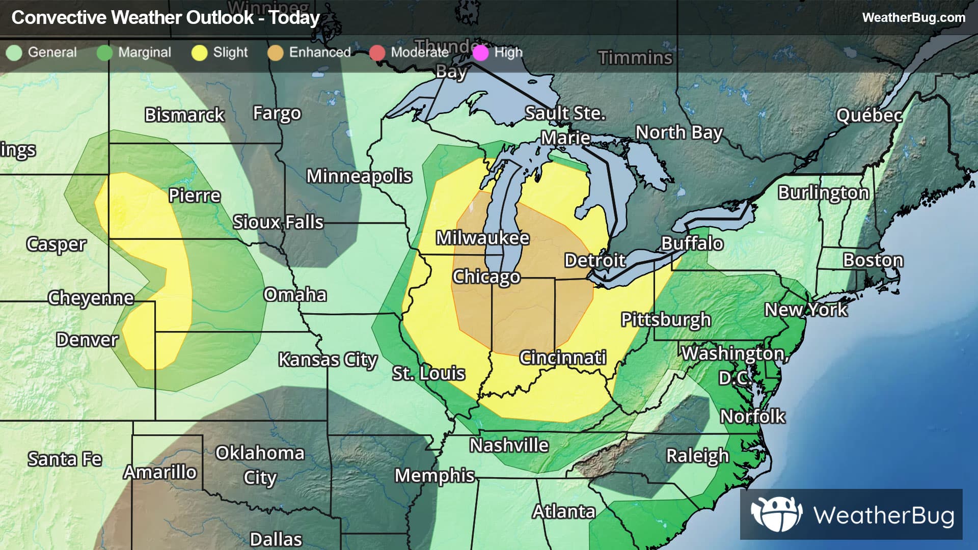
Strong to severe thunderstorms are expected to develop across the Great Lakes and Ohio Valley today, mainly this afternoon and evening.
A vigorous disturbance will track across the Great Lakes and Ohio Valley today and tonight, causing scattered to numerous showers and thunderstorms. Some of the thunderstorms will have the potential to produce torrential downpours, damaging wind gusts up to 60 to 70 mph, hail and even a couple of tornadoes. The thunderstorms will likely lead to some travel delays across this region of the country.
The government's Storm Prediction Center has issued an Enhanced Risk (level 3 out of 5) for southeastern Wisconsin, northern Illinois, northern/central Indiana and northwestern Ohio. Cities under this risk include Milwaukee, Chicago and Indianapolis.
There is also issued a Slight Risk (level 2 out of 5) that encompasses the Enhanced Risk for parts of central and northern Wisconsin, central and western Illinois, southern Indiana, the rest of Michigan, Ohio, northern Kentucky, far western Pennsylvania and parts of western West Virginia. Cities under this risk include Green Bay, Wis., Detroit and Marquette, Mich., Cleveland, Columbus and Cincinnati, Ohio, Louisville, Ky., Charleston, W.V. and Pittsburgh.
Severe Thunderstorm Watches are in effect for southeastern Illinois, southern Indiana and north-central Kentucky.
Storms produced quite the impact across the Chicago area where there were widespread reports of large hail and damaging wind gusts. A wind gust of 74 mph was reported at Chicago-Midway, while a gust of 64 mph was reported at Chicago O'Hare. Over 475,000 customers are without power this evening across Wisconsin, Illinios and Indiana.
Another Slight Risk also has been issued in far northeastern Wyoming, southwestern South Dakota, western Nebraska, far northwestern Kansas and far northeastern Colorado for this afternoon and evening. Main risks from thunderstorms will be damaging winds and hail. Cities within this risk include Rapid City, S.D., McCook, Neb., and Colby, Kan.
This disturbance will bring strong to severe thunderstorms across the Mid-Atlantic on Tuesday afternoon and evening along with the potential for heavy rain and flooding concerns across the New York City area and interior areas of the Northeast.
Be sure to know the difference between a watch and a warning. A watch means that the conditions are in place to possibly produce severe weather conditions, while a warning indicates that those conditions are currently occurring. Be sure to have multiple ways to receive warnings as storms will be occurring late tonight. Also, take caution if you are outdoors during a thunderstorm. Remember, “When Thunder Roars, Go Indoors!”