Severe Weather Eyes Northern Plains Through Tonight
Strong to severe thunderstorms will erupt across the northern Plains this afternoon and tonight leading to travel delays.
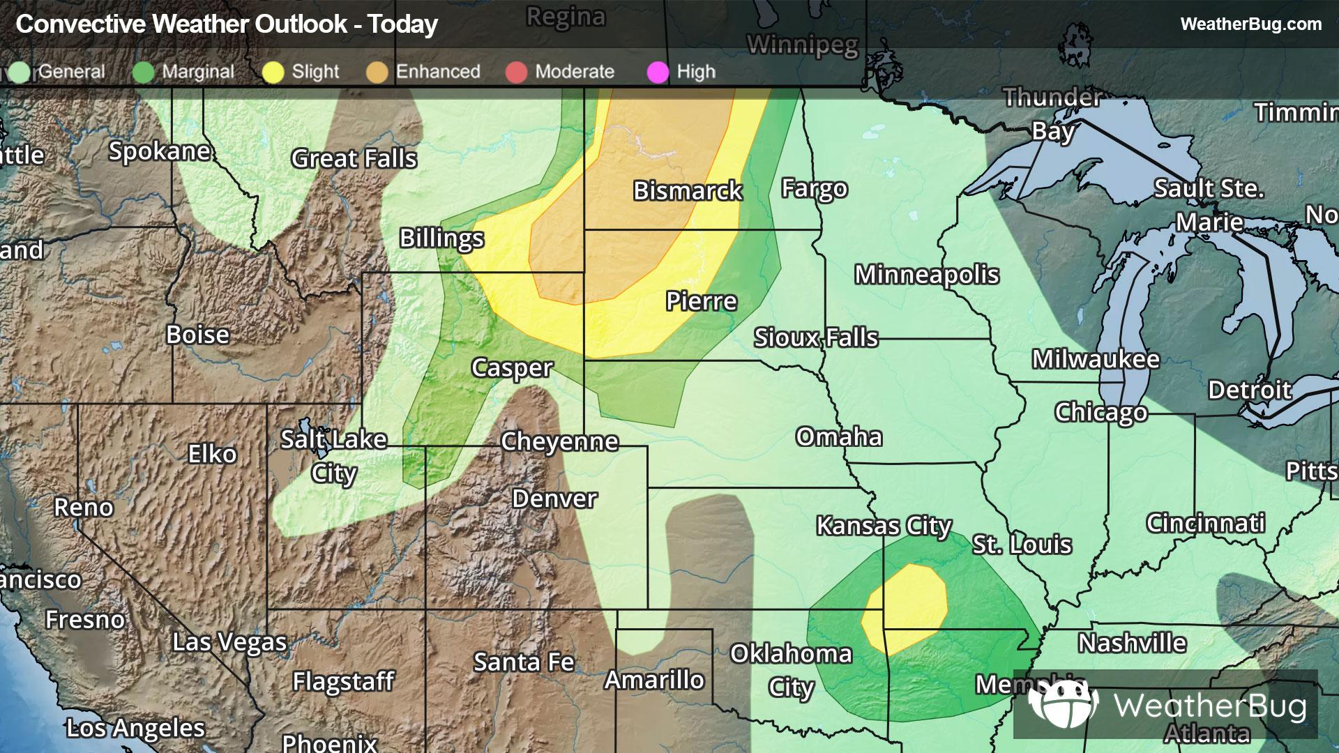
A vigorous disturbance will move across far eastern Montana, northeastern Wyoming, western South Dakota and North Dakota later this afternoon and evening causing thunderstorms to develop. Thunderstorms could produce heavy downpours, strong wind gusts, large hail and even a few tornadoes. The area of greatest concern will be across northeastern Wyoming into North Dakota.
A Tornado Watch is in effect for southwestern Missouri and northwestern Arkansas, which includes Harrison, Ark., and Springfield, Mo.
An Enhanced Risk, a 3 out of 5 on the severe weather probability scale, has been issued in far northeastern Wyoming, far southeastern Montana, northwestern South Dakota and much of North Dakota. This includes Minot and Bismarck, N.D. and Buffalo, S.D.
A Slight Risk, a 2 out of 5 on the severe weather probability scale, surrounds this area in North Dakota, western South Dakota, southeastern Montana and northeastern Wyoming. This includes Sheridan, Wyo. and Rapid City, S.D.
Another Slight Risk has been issued for far northeastern Oklahoma, far southeastern Kansas, far southwestern Missouri and far northwestern Arkansas. This includes Springfield, Mo. and Fayetteville, Ark.
In addition, parts of northern Texas, Oklahoma, southeast Kansas, and southwest Missouri are under Flood Watches as a separate system taps into a surge of deep tropical moisture pushing north across the southern Plains. This setup will bring the potential for heavy, slow-moving rainfall, with widespread totals of 1 to 3 inches and localized amounts reaching 3 to 5 inches or more. That raises the risk for flash flooding, especially in low-lying and flood-prone areas.
Make sure to know the difference between a watch and a warning should they be issued. A "watch" means that conditions are favorable for severe weather to occur, and to be on alert for any rapidly changing conditions. A "warning" means that severe weather is imminent, and you should act fast to remain safe.
The best way to remain safe is to stay prepared and informed about your local weather. Have a severe weather kit packed with a battery-operated radio, water, and non-perishable food items. Also, check the WeatherBug app frequently for any updates on today's severe weather. Remember, "When Thunder Roars, Go Indoors!"