Severe Storms To Fire Up Across The Midwest and Northeast
A very warm and humid air mass in place will allow for strong to severe thunderstorms to develop this evening and tonight across the Upper Midwest down into the Plains. A few feisty storms could also form across the Northeast and Mid-Atlantic this evening.
A Severe Thunderstorm Watch remains in effect for southeastern Nebraska, northwestern Missouri, and central and southwestern Iowa.
A Flash Flood Watch is in effect for southern and eastern Iowa, northwestern Illinois, northern Missouri, and central Wisconsin.
A vigorous disturbance will push a cold front through Minnesota and Wisconsin all the way down into the central Plains through tonight, causing thunderstorms to erupt. Thunderstorms will have the potential to produce locally heavy downpours, damaging wind gusts up to 60 to 80 mph, large hail, and even some tornadoes. Given the potentially dangerous nature of these storms, travel delays and disruptions seem likely.
Another area of thunderstorms will develop across the southern tier of New York, Pennsylvania, and the rest of the Mid-Atlantic this evening. The primary risks from these will be locally heavy downpours, strong wind gusts, and even a little hail.
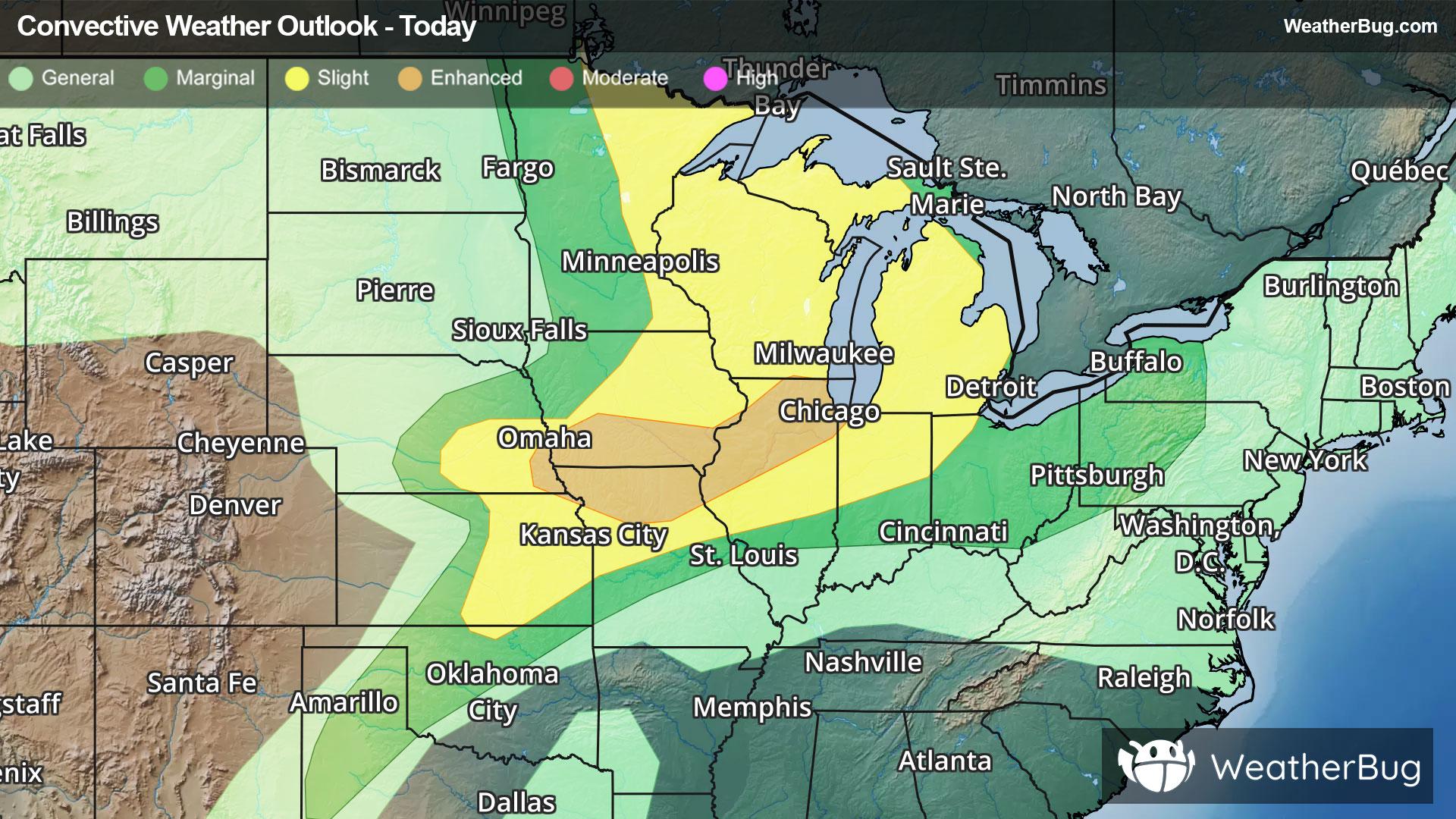
The government’s Storm Prediction Center has issued an Enhanced Risk (Level 3 out of 5) across far southeastern Nebraska, through southern Iowa and northern Missouri, and into northern Illinois. Cities under this risk include Chicago and Rockford, Ill., as well as Kirksville, Mo.
A Slight Risk (Level 2 out of 5) is in place around this Enhanced Risk from northern Minnesota and most of Michigan all the way down into eastern Nebraska and eastern Kansas. Cities under this risk include Des Moines, Iowa, Omaha, Neb., Kansas City, Mo., Wichita, Kan., Milwaukee, Detroit, and Toledo, Ohio.
A larger Marginal Risk (Level 1 out of 5) is in place from northwestern Texas and western Minnesota all the way into the interior Northeast and Mid-Atlantic. Cities include Lubbock, Texas, Columbus, Ohio, Pittsburgh and Minneapolis.
Make sure to know the difference between a watch and a warning should they be issued. A "watch" means that conditions are favorable for severe weather to occur, and to be on alert for any rapidly changing conditions. A "warning" means that severe weather is imminent, and you should act fast to remain safe.
The best way to remain safe is to stay prepared and informed about your local weather. Have a severe weather kit packed with a battery-operated radio, water, and non-perishable food items. Also, check the WeatherBug app frequently for any updates on today's severe weather. Remember, "When Thunder Roars, Go Indoors!"