


Severe Storms Rally Across the Midwest
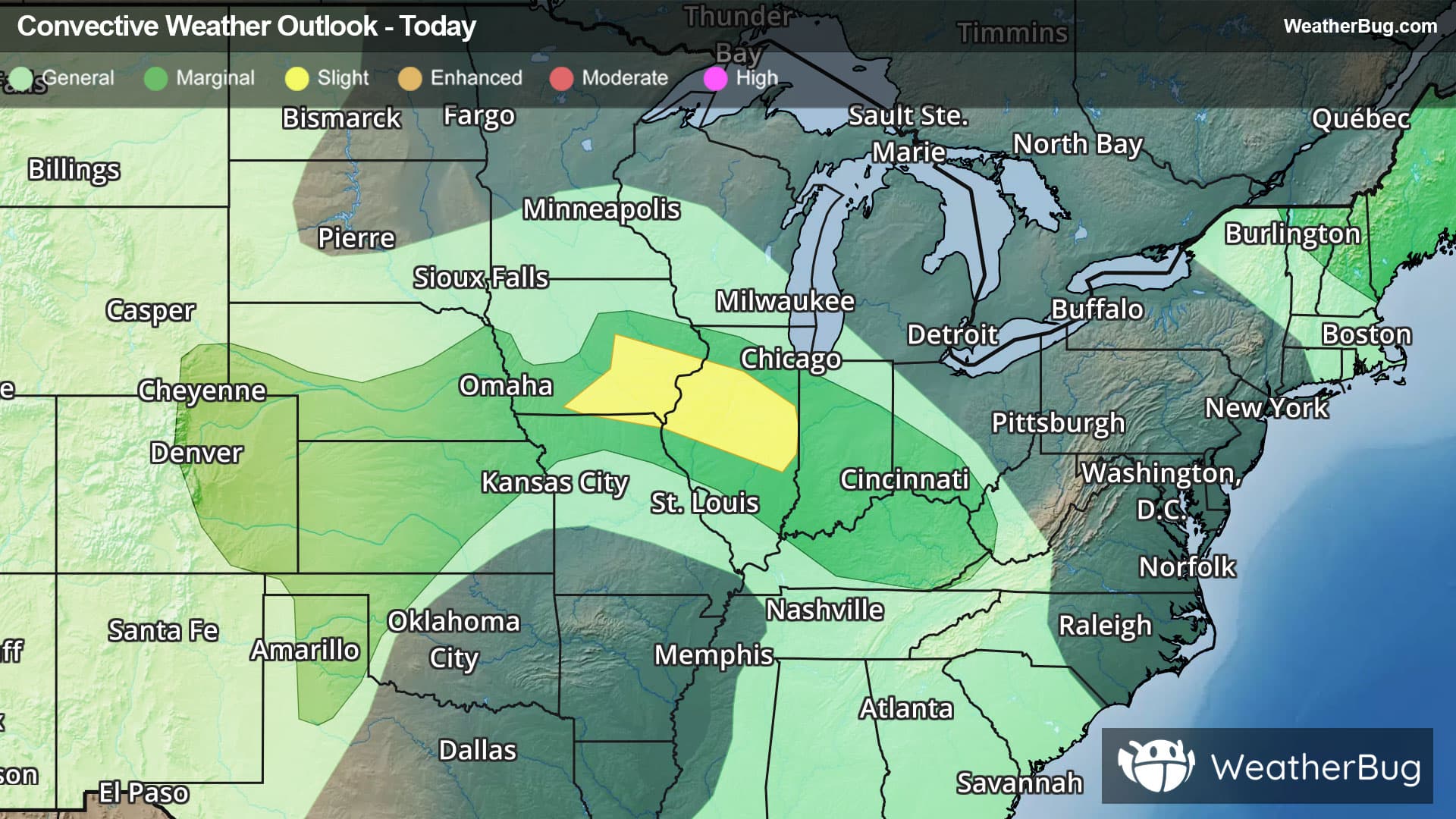
Severe thunderstorms will rally for yet another round today, focusing on the central Plains, the Great Basin, and particularly the Midwest.
Unstable air remains amped south of a stationary front between the High Plains and central Appalachia. These ingredients, alongside strong upper-level energy for the dog days of summer, will help launch further rounds of severe thunderstorm lines and complexes through the day today.
Severe Thunderstorm Watches are in effect for much of eastern Iowa.
The government's Storm Prediction Center has issued a Slight Risk, or a 2 out of 5 on the severe weather probability scale, for southern Iowa and central Illinois, where there is the best chance for isolated damaging winds and rare instances of large hail or even a tornado or two. Cities within this risk region include Des Moines, Davenport, and Cedar Rapids, Iowa, as well as Springfield and Peoria, Ill.
A larger Marginal Risk, a 1 out of 5, encompasses the Slight Risk and extends from the Texas Panhandle and southeastern Wyoming through eastern Kentucky and far southwestern West Virginia. Severe activity in these areas will remain sparse, but isolated damaging winds will remain possible with any strong thunderstorms.
Between mainly Nevada and western Utah, another Marginal Risk is at play today, where a few particularly bubbly monsoonal thunderstorms will be capable of bursting with damaging winds.
A final Marginal Risk has also been posted for northern New England, where isolated severe storms could bring the threats of large hail and damaging winds this evening into tonight.
Lastly, drenched soils from this week's multiple rounds of heavy rain will lack a significant break today, as continued thunderstorm activity further's flooding conerns in the Lower Midwest and Appalachia. Daily rain totals of 1 to 3 inches will also be common in the central Plains. Low-lying, urban, and poor drainage areas between these two regions will be susceptible to flooding today. Remember, when faced with floodwaters, "Turn Around, Don't Drown!"
A large swath of Flood Watches has been posted, reaching from Iowa through northeastern Tennessee, far northwestern North Carolina, southwestern Virginia, and western and central West Virginia. Separate Flood Watches are also present in central Nevada as well as Colorado’s Front Range.
Be sure to know the difference between a watch and a warning. A watch means that the conditions are in place to possibly produce severe weather, while a warning indicates that those conditions are currently occurring. Be sure to have multiple ways to receive warnings, as storms will be occurring late tonight. Also, take caution if you are outdoors during a thunderstorm. Remember, “When Thunder Roars, Go Indoors!”