Severe Storms Continue To Wreak Havoc on East, Gulf Coasts
The threat for severe thunderstorms continues this evening, with dangerous storms continuing to batter the Mid-Atlantic, Mid-South and Gulf Coast.
A large cold front stretching from eastern Canada to Texas is the cause of the early-March weather madness. Unseasonably warm air ahead of it is clashing with cold air on the storm’s backside, leading to thunderstorm development.
Tornado Watches are in effect across southeastern Alabama, the panhandle of Florida and into parts of Georgia. This includes Pensacola, Fla. and Macon, Ga.
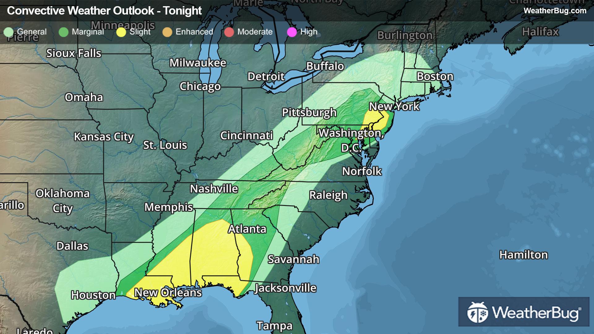
Isolated strong to severe thunderstorms have been forming well ahead of the front and will continue to do so well into the night. The Storm Prediction Center has posted a large Slight Risk (a 2 out of 5 on the severity scale), bending along the Lower Mississippi and Ohio River Basins into the southern Mid-Atlantic. Urban areas within the risk include New Orleans, Nashville, Tenn., Indianapolis, Louisville, Ky., Charleston, W. Va., Pittsburgh, Philadelphia, Baltimore, and Washington, D.C.
Within the Slight Risk, two regions are expected to hold either more concentrated or intense severe weather. The first is across the Lower Mississippi Basin, where damaging winds will likely be more intense. The second covers the Upper Ohio Basin and the Alleghenies, where damaging winds and hail impacts will be more concentrated. Both regions are expected to observe more pervasive and stronger tornadic activity, though isolated at best.
The storms have quite a history this week. Two people were killed in Illinois yesterday when a tornado hit a manufactured home. Odell and Pontiac, Ill., were among the communities to see softball sized hail. In all, more than 250 reports of wind damage have occurred this week from the Plains to the East Coast.
Soaking rain, often in a short period, will be another impact to watch for underneath strong thunderstorms. Totals of 1 to 2 inches are likely for the Mid-South and Lower Great Lakes, with locally 2 to 3 inches or more possible from eastern Texas through western Alabama. This may lead to urban flooding, especially where poor drainage exists. If you approach a road covered in water, remember the old saying, “Turn Around, Don’t Drown!”
Make sure to know the difference between a watch and a warning should they be issued. A "watch" means that conditions are favorable for severe weather to occur, and to be on alert for any rapidly changing conditions. A "warning" means that severe weather is imminent, and you should act fast to remain safe.
The best way to remain safe is to stay prepared and informed about your local weather. Have a severe weather kit packed with a battery-operated radio, water, and non-perishable food items. Also, check the WeatherBug app frequently for any updates on today's severe weather. Remember, "When Thunder Roars, Go Indoors!"