Big Storms Pelt Southern Plains to the Great Lakes, Ohio Valley Tonight
Summer-like warmth and humidity will help fuel rounds of severe thunderstorms from the nation’s midsection into the Northeast tonight.
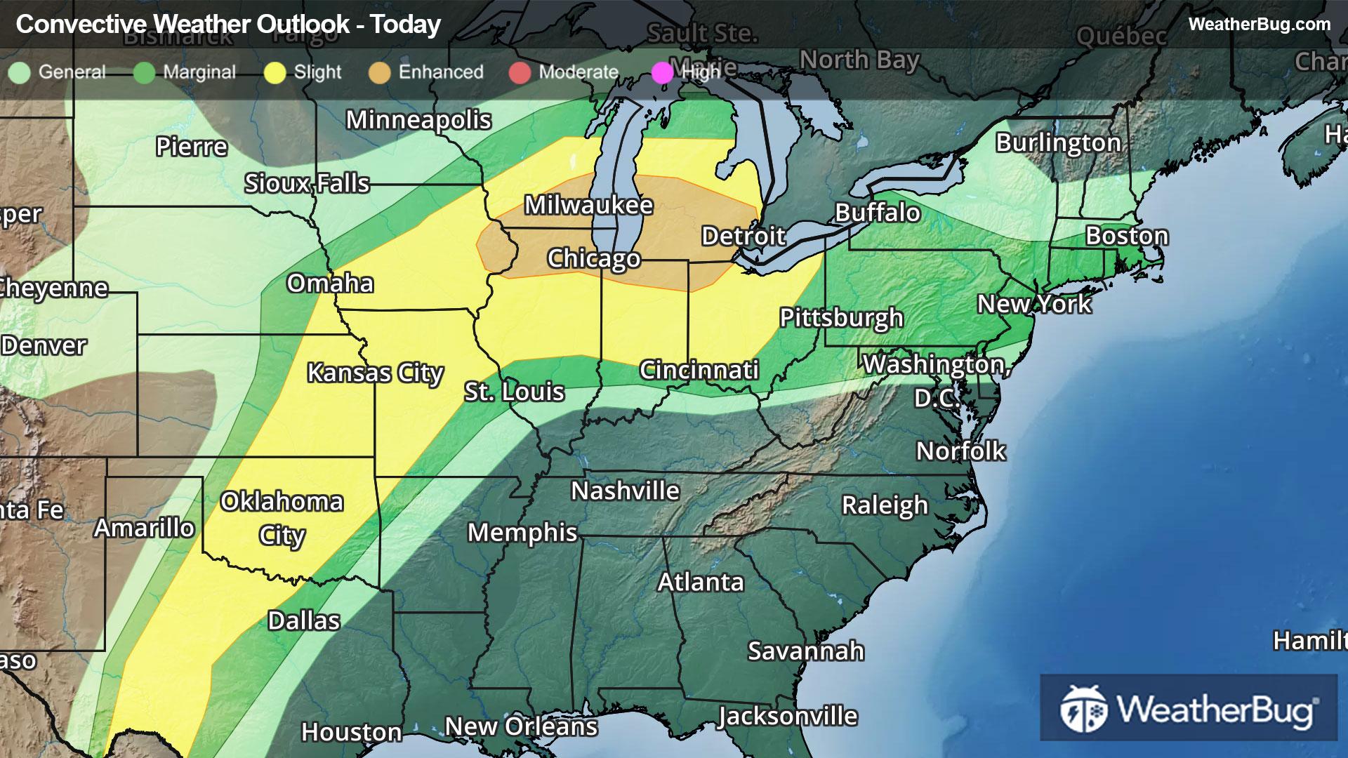
A front extending from the southern Plains into the Midwest and Great Lakes is separating summer-like warmth and humidity to its east from cooler, drier air to its west. These colliding air masses have fostered oodles of dangerous weather so far today.
An Enhanced Risk has been maintained by the government’s Storm Prediction Center for the Lower Great Lakes and northern Ohio Valley tonight. This zone includes Chicago and Rockford, Ill., to Milwaukee, Fort Wayne, Ind., and as far east as Flint and Detroit, Mich. A larger zone of potentially dangerous thunderstorms could extend from the Texas Big Bend area to the northern and eastern Great Lakes.
Tornado Watches are in effect for southeastern Michigan, including Detroit and Flint, Mich.
Severe Thunderstorm Watches are in effect for portions of northeastern Oklahoma, northwestern Arkansas, and southwestern Missouri. Severe Thunderstorm Watches are also in effect across southeastern Nebraska, northwestern Missouri, and southern and eastern Iowa. Severe Thunderstorms Watches are also in effect across northern Ohio.
Isolated damaging wind gusts up to 75 mph, isolated large, destructive hail up to baseball to softball size, and tornadoes are likely. A few intense tornadoes will be possible.
Recent heavy rainfall, including tonight, and snowmelt may team up to produce flooding issues across parts of Michigan, northeastern Illinois, and far northern Indiana and Ohio. Flood Watches are in effect here, including Chicago, Detroit, and Milwaukee. Remember, if you approach a flooded roadway, it is best to “Turn Around, Don’t Drown!”
Additional strong to severe thunderstorms are in the forecast for midweek. The threats will stretch across familiar places from the southern Plains to the Midwest, Great Lakes, Ohio Valley, and possibly parts of the Northeast.
Make sure to know the difference between a watch and a warning should they be issued. A "watch" means that conditions are favorable for severe weather to occur, and to be on alert for any rapidly changing conditions. A "warning" means that severe weather is imminent, and you should act fast to remain safe.
The best way to remain safe is to stay prepared and informed about your local weather. Have a severe weather kit packed with a battery-operated radio, water, and non-perishable food items. Also, check the WeatherBug app frequently for any updates on today's severe weather. Remember, "When Thunder Roars, Go Indoors!"