Back to forecast
Severe Storms Target Upper Midwest, Northern Plains
June 16, 2026 at 09:26 AM EDT
UPDATED By WeatherBug's Keegan Miller
Building heat and humidity across the Plains will collide with a cooler, drier air mass to help ignite severe thunderstorms over the northern Plains and Upper Midwest later today and tonight.
A series of upper-air disturbances will track eastward near the U.S.-Canada border this afternoon and evening and will move over a slow-moving cold front. This will result in the development of severe thunderstorms during the afternoon and evening hours today.
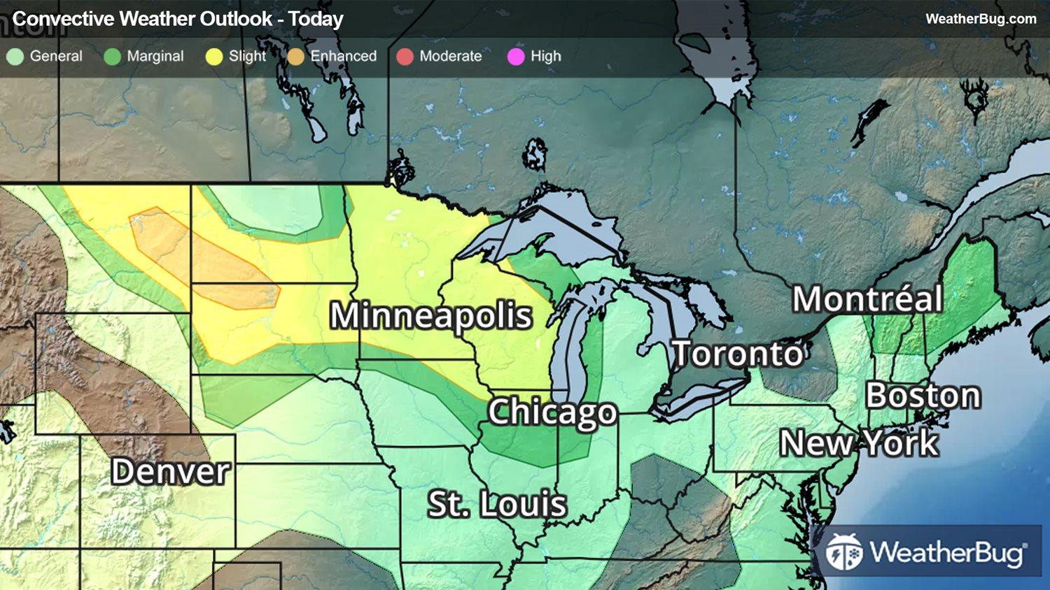
The government's Storm Prediction Center has issued an Enhanced Risk, a 3 out of 5 on the severe weather probability scale, for far eastern Montana, southwestern North Dakota, and northwestern South Dakota. Some notable towns under this risk are Glendive, Mont., and Dickinson, N.D.
A Slight Risk, or a 2 out of 5 on the severe weather probability scale, has also been issued for across portions of northeastern Montana, much of the Dakotas, Minnesota, Wisconsin, and far northern Illinois. Cities at risk under this much larger swath include Glasgow, Mont., Bismarck, N.D., Pierre, S.D., Minneapolis, and Milwaukee.
The main impacts from thunderstorms in this region will be damaging winds in excess of 60 mph and golf ball-sized hail. However, an isolated tornado or two cannot be ruled out either, and locations in the enhanced risk area are much more likely to see each of these threats.
Severe Thunderstorm Watches have been issued for central South Dakota, central Minnesota and western Wisconsin. This includes the city of Minneapolis and Pierre, S.D.
Some other parts of the nation could see strong to severe storms too, such as the Great Basin, which will see heavy monsoonal winds and rain. Northern New England is also under threat of strong wind gusts and hail due to a particularly unstable atmosphere. Cities under these risk areas include Las Vegas and Eureka, N.V., Burlington, Vt., and Houlton, Maine.
Make sure to know the difference between a watch and a warning should they become issued. A watch means that conditions are favorable for severe weather to occur and to be on alert for any rapidly changing conditions. A warning means that severe weather is imminent, and you should act fast to remain safe.
The best way to remain safe is to stay prepared and informed about your local weather. Have a severe weather kit packed with a battery-operated radio, water and non-perishable food items should you be without power for long periods of time. Also, check the WeatherBug app frequently for any updates on today's severe weather. Remember, “When Thunder Roars, Go Indoors!”
A series of upper-air disturbances will track eastward near the U.S.-Canada border this afternoon and evening and will move over a slow-moving cold front. This will result in the development of severe thunderstorms during the afternoon and evening hours today.
The government's Storm Prediction Center has issued an Enhanced Risk, a 3 out of 5 on the severe weather probability scale, for far eastern Montana, southwestern North Dakota, and northwestern South Dakota. Some notable towns under this risk are Glendive, Mont., and Dickinson, N.D.
A Slight Risk, or a 2 out of 5 on the severe weather probability scale, has also been issued for across portions of northeastern Montana, much of the Dakotas, Minnesota, Wisconsin, and far northern Illinois. Cities at risk under this much larger swath include Glasgow, Mont., Bismarck, N.D., Pierre, S.D., Minneapolis, and Milwaukee.
The main impacts from thunderstorms in this region will be damaging winds in excess of 60 mph and golf ball-sized hail. However, an isolated tornado or two cannot be ruled out either, and locations in the enhanced risk area are much more likely to see each of these threats.
Severe Thunderstorm Watches have been issued for central South Dakota, central Minnesota and western Wisconsin. This includes the city of Minneapolis and Pierre, S.D.
Some other parts of the nation could see strong to severe storms too, such as the Great Basin, which will see heavy monsoonal winds and rain. Northern New England is also under threat of strong wind gusts and hail due to a particularly unstable atmosphere. Cities under these risk areas include Las Vegas and Eureka, N.V., Burlington, Vt., and Houlton, Maine.
Make sure to know the difference between a watch and a warning should they become issued. A watch means that conditions are favorable for severe weather to occur and to be on alert for any rapidly changing conditions. A warning means that severe weather is imminent, and you should act fast to remain safe.
The best way to remain safe is to stay prepared and informed about your local weather. Have a severe weather kit packed with a battery-operated radio, water and non-perishable food items should you be without power for long periods of time. Also, check the WeatherBug app frequently for any updates on today's severe weather. Remember, “When Thunder Roars, Go Indoors!”