Severe Storms to Strike the Northeast & Plains
Today, a cold front sweeps severe impacts across the Ohio Valley and Northeast as a new storm system creates separate yet similar dangers in the northern High Plains.
A Severe Thunderstorm Watch has been issued for southwestern Ohio, southwestern Pennsylvania, and northern West Virginia.
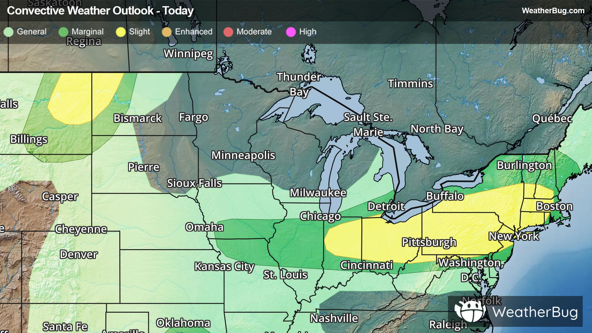
Continuing forward from Friday’s severe activity, unstable and humid air continues to funnel in ahead of a strong cold front as it both sinks into the Ohio Valley and traverses the Great Lakes, Appalachia, the Mid-Atlantic, and New England. Further west, a disturbance jumps off the northern Rockies and into the far northern High Plains, where ingredients also synergize for severe weather this afternoon and evening.
Two separate Slight Risks, a 2 out of 5 on the severe weather probability scale, have been posted for today. The first stretches from Ohio through central Massachusetts, including major cities such as Cleveland, Pittsburgh, Philadelphia, and New York City. The second straddles the Montana-North Dakota border, including Dickinson, N.D., as well as Miles City and Glendive, Mont.
The most intense storms, isolated supercells and small lines of severe thunderstorms, will be capable of damaging gusts up to 70 mph, hail greater than 2 inches in diameter, localized flash flooding, and even a few tornadoes mainly in the Upper Ohio Valley.
Marginal Risks, a 1 out of 5 on the severe weather probability scale, encompass each Slight Risk, with one extending across the Lower Midwest to cover stray early severe thunderstorms along the front. Additionally, a completely separate risk covers areas of central Texas and south-central Oklahoma, where very isolated supercells could produce hail and damaging winds.
In addition, Flash Flood Watches have been put up for parts of northern Texas and Oklahoma for a separate weather system. These areas could pick up 1 to 3 inches of rain with localized 3 to 5 inches today.
Make sure to know the difference between a watch and a warning should they be issued. A "watch" means that conditions are favorable for severe weather to occur, and to be on alert for any rapidly changing conditions. A "warning" means that severe weather is imminent, and you should act fast to remain safe.
The best way to remain safe is to stay prepared and informed about your local weather. Have a severe weather kit packed with a battery-operated radio, water, and non-perishable food items. Also, check the WeatherBug app frequently for any updates on today's severe weather. Remember, "When Thunder Roars, Go Indoors!"