


Severe Weather, Heavy Rain Pockets Across the U.S.
As summer kicks into its latter half, pockets of robust summertime thunderstorms will form over the Great Plains, Northeast, and Southwest today.
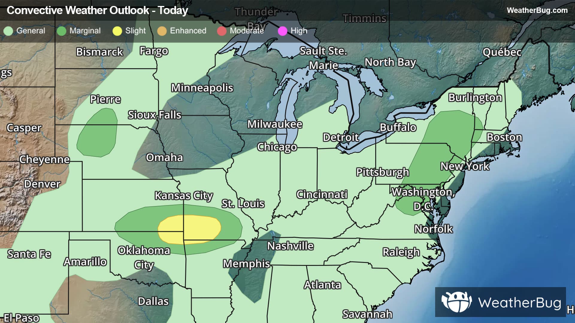
In the Great Plains, two distinct regions can expect isolated strong to severe thunderstorms. The larger of the two will focus near the western extent of the Mid-Mississippi Valley, where an upper-level disturbance ignites a moist, unstable air mass this afternoon and evening. A few supercells and severe, segmented thunderstorms have the ingredients to form a few hailstorms and damaging wind gusts, some nearing 70 mph.
The government's Storm Prediction Center has posted a Slight Risk, a 2 out of 5 on the severe weather probability scale, for portions of southwestern Missouri, southeastern Kansas, northeastern Oklahoma, and far northwestern Arkansas. Cities within this risk level today include Bentonville, Ark., as well as Springfield and Joplin, Mo. A Marginal Risk, a 1 out of 5, encapsulates this region as well, including Tulsa, Okla., and Wichita, Kan.
A second risk region in the Plains, harboring a Marginal Risk on the day, is centered over north-central Nebraska and south-central North Dakota. Strong instability may create a few severe thunderstorms capable of hail and damaging winds, although gusts here are expected to be weaker and less concentrated.
Similarly but separately, the Mid-Atlantic will also face isolated, gusty severe thunderstorms, enabled by high moisture siphoned from tropical seas to the south. Another Marginal Risk covers this region, including major cities such as Washington, D.C., Baltimore, and Philadelphia.
Heavy rain is also problematic today, squeezed out above Appalachia, beneath the southwestern monsoon, and ahead of a stalled front in the Midwest. Rain totals of 1 to 3 inches are likely beneath thunderstorms in these areas. Specifically, localized rain totals nearing 4 inches will be possible in the Lower Midwest, where ongoing complexes of thunderstorms are already soaking the ground. Remember, "Turn Around, Don't Drown!"
Flood Watches and Flood Advisories are in effect for parts of southern Arizona as well as north-central Missouri, southwestern Illinois, and far eastern Kansas.
Be sure to know the difference between a watch and a warning, should they be issued. A watch means that the conditions are in place to possibly produce severe weather conditions, while a warning indicates that those conditions are currently occurring. Be sure to have multiple ways to receive warnings, as storms will be occurring late tonight.
Also, take caution if you are outdoors during a thunderstorm. Remember, “When Thunder Roars, Go Indoors!”