Severe Weather Outbreak Targets the Midwest
The Mississippi Valley remains abloom with severe thunderstorms this evening, with the threat stretching from Minnesota to Missouri and even along the Gulf Coast.
The primary threat is thanks to a strong cold front marching through the Plains. Ahead of it, warm, moist air is interacting with strong shear, or turning of the wind. This is leading to severe thunderstorms and in many cases, tornadoes.
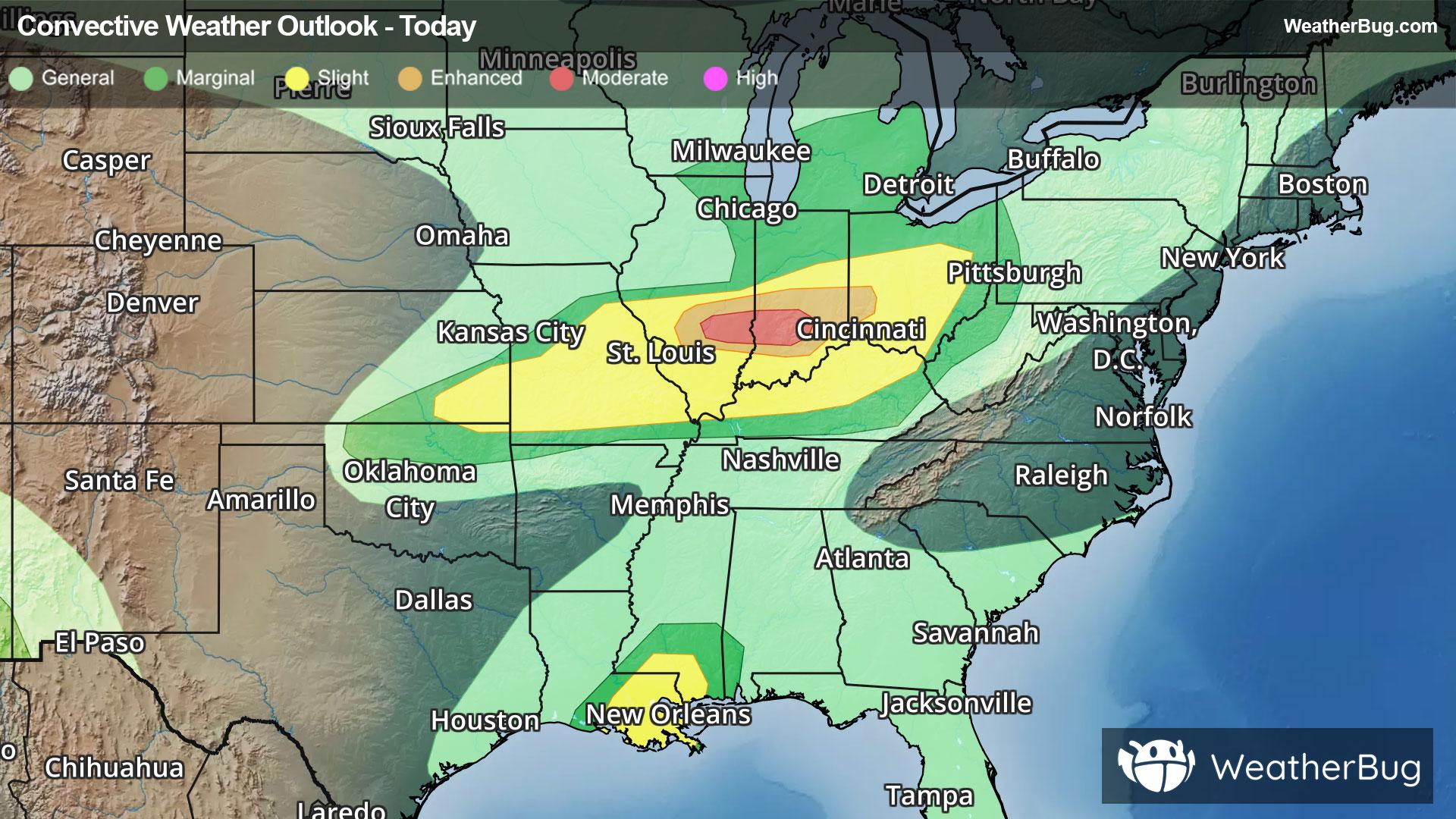
A small Moderate Risk (a level 4 of 5 on the severe weather probability scale) is in place for central Illinois and Indiana, including towns such as Bloomington, Ill., and Terre Haute, Ind. An Enhanced Risk (level 3 of 5) also extends into western Ohio. This includes Indianapolis as well as Dayton, Ohio. Surrounding that is a zone of Slight Risk, which encompasses the landscape from southeastern Kansas to central Ohio. Cities such as St. Louis, Louisville, Ky., and Cincinnati and Columbus, Ohio, are also at risk for severe thunderstorms tonight.
The greatest threat from thunderstorms will be gusty winds exceeding 70 mph and long-lived, intense tornadoes. As a result, Tornado Watches are in effect from southern Illinois to southwestern Ohio and northern Kentucky. This includes Indianapolis and Evansville, Ind., Cincinnati and Dayton, Ohio, and Louisville, Ky.
In addition to the severe thunderstorms, heavy rainfall is likely across southwestern Ohio, southern Indiana, and southeastern Illinois, where Flood Watches are in effect. Rain rates may exceed 2 inches per hour in some locations, with rainfall totals of 2 to 3 inches possible. The result of the intense rainfall will be quick and sudden flooding of roadways, creeks, and low-lying and poor drainage areas. Remember, if you approach a road covered in water, follow a simple motto – “Turn Around, Don’t Drown!”
Meanwhile, another area of severe thunderstorms is bubbling up along the central Gulf Coast of eastern Louisiana and southern Mississippi, where another Slight Risk has been posted. This is along and to the east of Post-Tropical Cyclone Arthur, which is poised to enter Louisiana tonight. Places such as New Orleans and Baton Rouge, La., may see a few tornadoes develop along the eastern fringe of the storm as Gulf moisture streams inland.
There is a Tornado Watch in effect for southeastern Louisiana and southern Mississippi, including New Orleans and Baton Rouge, La., as well as Biloxi, Miss.
Make sure to know the difference between a watch and a warning should they become issued. A watch means that conditions are favorable for severe weather to occur and to be on alert for any rapidly changing conditions. A warning means that severe weather is imminent, and you should act fast to remain safe.
The best way to remain safe is to stay prepared and informed about your local weather. Have a severe weather kit packed with a battery-operated radio, water and non-perishable food items should you be without power for long periods of time. Also, check the WeatherBug app frequently for any updates on today's severe weather. Remember, “When Thunder Roars, Go Indoors!”