Back to forecast
Big Storms, Increasing Flood Risk Eye Eastern, Southern U.S.
May 22, 2022 at 05:09 PM EDT
Updated By WeatherBug Meteorologist, Fred Allen
The weekend will finish in a waterlogged, stormy fashion across much of the Eastern Seaboard. Heavy rain could lead to flooding, while thunderstorms will deliver gusty winds, large hail and a tornado or two.
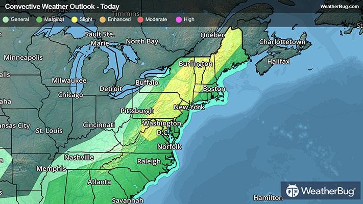
A cold front slicing into an unseasonably hot and humid air mass parked along the Eastern Seaboard is beginning to trigger dangerous thunderstorm development from northern Virginia to south-central New York this afternoon. Rumbling east toward the Interstate 95 corridor, these thunderstorms will intensify and could pack damaging wind gusts up to 70 mph and hail larger than quarters. A brief tornado cannot be ruled out either, especially across northern and western Maine.
Cities such as Washington, D.C., Baltimore, Philadelphia and Scranton, Pa., Binghamton and Albany, N.Y., to Burlington, Vt., Concord, N.H., and Caribou, Maine, are the cities most at risk for a dangerous storm encounter. This is the same area the government’s Storm Prediction Center has maintained a Slight Risk for severe thunderstorms this afternoon and evening.
Severe Thunderstorm Watches stretch from much of Maine to the eastern West Virginia Panhandle and northern Virginia. Charlottesville, Va., Washington, D.C., Baltimore, Philadelphia, Scranton, State College and Allentown, Pa., Binghamton and Albany, N.Y., Concord, N.H., Burlington, Vt., and Bangor, Augusta and Caribou, Maine, are included.
Rainfall totals surpassing an inch will be localized from the Mid-Atlantic northward to New England which will keep the flooding risk to urban areas where ponding could occur. Further south, repetitive downpours and thunderstorms could lead to several inches of rain on a localized basis, especially for Alabama up to the southern Appalachian Spine in eastern Tennessee and western North Carolina. This will result in an increased flood risk through the start of the work week. Remember, if you approach a flooded roadway, it is best to “Turn Around, Don’t Drown.”
Being aware of your surroundings and having a plan of action are the best ways to stay safe during severe weather events. Have multiple ways to receive warnings for your location and be sure to shelter in a basement or interior room within a well-built structure when severe weather approaches. Also remember that it is always a good idea to stay indoors during thunderstorms of any strength and that it is never a good idea to walk or drive through flooded areas.