


Severe Weather and Flooding Eye Mid-Atlantic, Upper Midwest
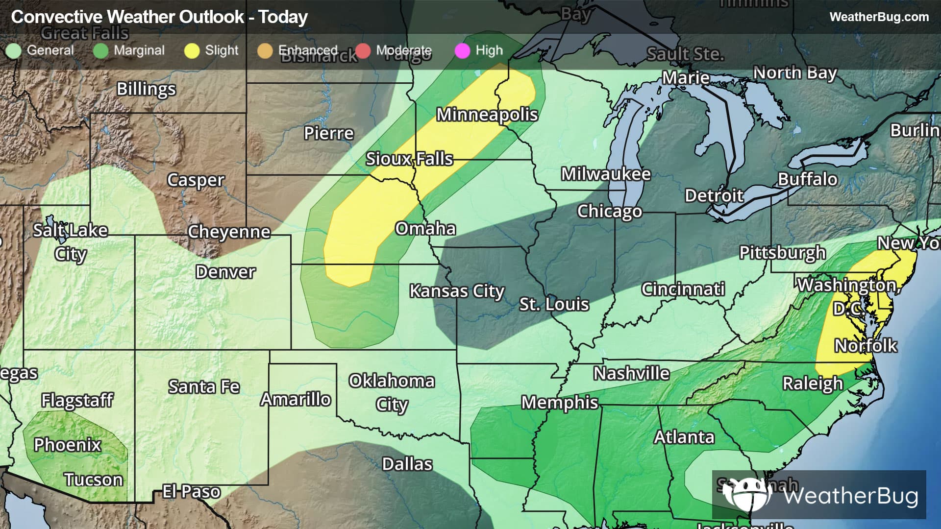
Separate alleys of severe weather arise today, bringing threatening storms to both the Upper Midwest and Mid-Atlantic.
From overnight thunderstorm activity, a Severe Thunderstorm Watch remains in effect for north-central Tennessee.
In the Mid-Atlantic, a particularly moist air mass will pull ahead of a strong cold front for summer standards. As a result, severe storms will become embedded within the front this late afternoon, bringing at least widely scattered damaging wind gusts alongside isolated large hailstones and even a few tornadoes.
The government's Storm Prediction Center has posted a Slight Risk, a 2 out of 5 on the severe weather probability scale, from far northeastern North Carolina to central New Jersey, which includes the cities of Virginia Beach and Richmond, Va., Washington, D.C., Baltimore, Philadelphia, and Newark and Trenton, N.J.
Although with more scarce coverage, a much larger Marginal Risk, a 1 out of 5, extends from New York City through southern and central Appalachia and into the Deep South. Isolated instances of damaging winds will be possible for these regions.
Further west, a separate Slight Risk is posted from northwestern Wisconsin to northwestern Kansas, where a separate cold front will form isolated severe storms capable of a few tornadoes, damaging winds, and, in the central Plains, heftier hailstones of up to 2" or more in diameter. Cities in the Slight Risk include Minneapolis and St. Paul, Min., Sioux City, Iowa, and Kearney, Neb. Another Marginal Risk also encapsulates the higher risk region.
A final, less impactful corridor of severe weather will form in southern Arizona, where the threat for isolated monsoonal thunderstorms with damaging winds warrants a final Marginal Risk.
Aside from the severe threats, heavy rain and flash flooding will also be a major concern today in the Mid-Atlantic. Daily rain totals of 1 to 3 inches, and local totals approaching 4 inches or more, will be possible across central Pennsylvania and the Mid-Atlantic. Remember, when facing flooded roadways, "Turn Around, Don't Drown!"
Flood Watches and Flood Advisories are currently in effect from southeastern Missouri to south-central Kentucky, from central Illinois to far southwestern Pennsylvania, and in southeastern Pennsylvania through much of New Jersey to around the New York City area.
Be sure to know the difference between a watch and a warning. A watch means that the conditions are in place to possibly produce severe weather, while a warning indicates that those conditions are currently occurring. Be sure to have multiple ways to receive warnings, as storms will be occurring late tonight. Also, take caution if you are outdoors during a thunderstorm. Remember, “When Thunder Roars, Go Indoors!”