Back to forecast
Winter Storm Brings Fresh Snow to Pacific Northwest, Plains
November 28, 2022 at 06:00 AM EST
UPDATED By WeatherBug Meteorologists
The newest winter storm will continue to bring fresh snow across Pacific Northwest to kick off this week. This same system will push eastward and bring winter storm conditions to the Great Plains and northern U.S.
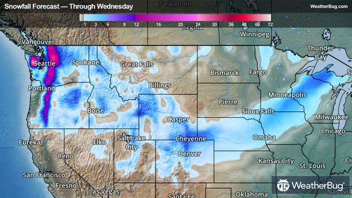
Moderate to heavy snowfall will continue today across the Pacific Northwest, creating a wintry wonderland across several mountain ranges.
Peak snowfall will likely occur in western Washington, where Winter Storm Warnings and Winter Weather Adviories are in place for 1 to 3 feet of new snow. In the higher elevations of Oregon, Idaho, western Montana, western Wyoming and western Colorado, snow amounts of 6 to 12 inches will be commonplace, with locally higher totals up to 18 to 24 inches possible.
Gusty winds up to 30 to 40 mph will accompany the snow in some areas, so be careful when heading out as the combined snow and wind could greatly reduce visibility. Wind Advisories and High Wind Warnings can be found across Montana into southeastern Wyoming as a result. Isolated wind gusts ranging from 55-80 mph will be possible today for cities such as Harve, Bozeman and Great Falls, Mont., and Casper and Laramie, Wyo.
As the storm progresses eastward to start the work week, Winter Storm Warnings and Winter Weather Advisories in effect for central Utah, southeastern Wyoming and central Colorado. This includes the Sierra Madre Range and Snowy Range in Wyoming, and Elkhead and Park Mountains in Colorado where snow accumulations up to 14 inches will be possible through Tuesday with isolated totals up to 18 inches possible. Winds will be breezy as well, with gusts as high as 45 mph possible.
Additional Winter Weather Advisories can be found across Nebraska, extreme southeastern South Dakota, northwestern Iowa and southwestern Minnesota as this system builds over the Great Plains. Here, snowfall totals up to 4 inches will be possible as well as wind gusts up to 35 mph which will create dangerous travel conditions. Winter Storm Watches have been issued as well for northern Wisconsin and Michigan's Upper Peninsula where 4-7 inches will be possible but isolated totals up to 10 inches cannot be ruled out.
It’s never too early to have a supply kit packed in case of inclement weather. A simple kit including a weather radio, water, blankets, batteries and non-perishable food items will go a long way in the event of a power outage. It’s always best to avoid travel in rough weather as the roads will be dangerous.