Back to forecast
Heavy Snow Hits Northern U.S., With Heavy Rain In The East
March 22, 2024 at 07:21 AM EDT
UPDATED by WeatherBug Meteorologist, Mark Ellinwood
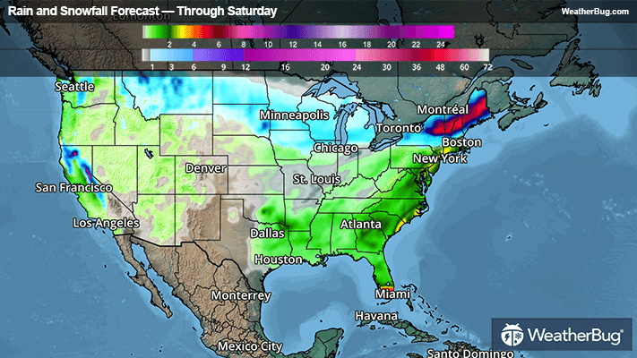
A band of moderate to heavy snow will travel from Montana to Maine through Saturday, with heavy rain and breezing conditions working up the East Coast on Saturday.
A broad disturbance will produce a band of snow from the northern Rockies to the Upper Great Lakes through this evening, which will shift into northern New York and northern New England tonight into Saturday. This will result in widespread snowfall of 3 to 8 inches, with locally higher amounts of 8 to 12 inches possible. Far northern New England could see as much as 12 to 18 inches!
On the southern edge of the snow band, a wintry mix including freezing rain is likely from northern Nebraska and southern South Dakota to the interior parts of New England. Ice accumulations will generally be a tenth of an inch or less, but localized areas up to a quarter inch of ice are possible.
Winter Weather Advisories and Winter Storm Watches and Warnings are in place from Montana to the northern Plains, Upper Midwest, and much of the Northeast.
As a cold front combines with a disturbance in the southeastern U.S., a large area of moderate to heavy rain will develop in the eastern U.S. Parts of the Southeast will see areas of 1 to 3 inches of rain today into early Saturday, with similar rain amounts moving up through the Mid-Atlantic, southern New England, and coastal Maine on Saturday.
The heavy rain could cause areas of flash flooding, with Flood Watches in place across southern Florida and up the I-95 corridor from Washington, D.C. to Boston and coastal Maine.
It’s never too early to have a supply kit packed in case of inclement weather. A simple kit including a weather radio, water, blankets, batteries, and non-perishable food items will go a long way in the event of a power outage. It’s always best to avoid travel in rough weather as the roads will be dangerous.