Storm Pummels Eastern U.S.
A strong disturbance will sweep across the eastern U.S. today bringing various impacts including rain and thunderstorms, snow and even strong wind gusts.
Rain and embedded thunderstorms are already happening this morning and will push eastward as we progress throughout the rest of the morning and early afternoon. Locally heavy rain will be possible in embedded thunderstorms. This can basically occur from southern Maine down into the Carolinas.
Colder air will move in behind the cold front associated with this storm bringing snow to parts of northern New England and upstate New York for this afternoon and evening. Snow totals of 1 to 3 inches are expected for the central Appalachian spine and up into parts of northern New England. Snow totals of 3 to 6 inches will fall east of Lake Erie and Lake Ontario due to lake effect snow.
A few Winter Weather Advisories have been issued east of Lake Erie and Lake Ontario.
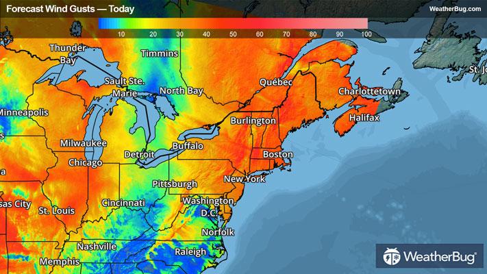
Strong winds will be the main concern for the Northeast and Mid-Atlantic, where gusts of 45 to 60 mph are expected, with the greatest impact coming this morning and early afternoon. Along the cold front, a line of gusty showers and thunderstorms will likely impact the I-95 corridor this morning into early afternoon. Winds should begin to lessen some by this evening.
High Wind Warnings and Wind Advisories are also already posted for the Appalachian Spine, a few parts of the Southeast and the entire Mid-Atlantic and Northeast.
Be sure to download the WeatherBug app to stay up to date on the latest on this changing weather. It’s never too early to have a supply kit packed in case of inclement weather. A simple kit including a weather radio, water, blankets, batteries, and non-perishable food items will go a long way in the event of a power outage.