Storms Bring Flood and Severe Risk to High Plains
A robust low pressure system will continue to deliver severe weather to the High Plains tonight.
The system tracking across the High Plains will help thunderstorms continue to organize this evening across the northern Plains, with a primary cluster of storms strengthening over southwest North Dakota. Additional storms will erupt along a frontal boundary into eastern Montana and across southwest South Dakota. While supercells capable of isolated very large hail will remain possible, storms are increasingly evolving into clusters and lines.
As a result, the main threat is shifting toward widespread damaging wind gusts of 60 to 85 mph across the western Dakotas through the evening. A few tornadoes remain possible from west-central North Dakota into northwest Nebraska. The North Dakota storms should weaken later tonight as they move into central and eastern parts of the state, while activity across South Dakota may persist longer before gradually diminishing.
A Tornado Watch is in effect western North Dakota, northern Nebraska, and central South Dakota.
Severe Thunderstorm Watches are in effect for portions of North Dakota, southeastern South Dakota and far northern Nebraska.
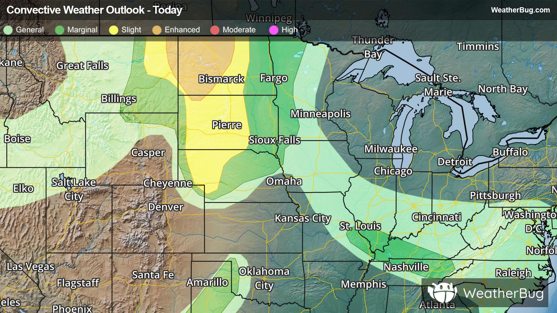
The Storm Prediction Center has an Enhanced Risk (level 3 of 5) for far eastern Montana, western North Dakota, and northwestern South Dakota. A Slight Risk (level 2 of 5) is highlighted over eastern Montana, northwestern Wyoming, much of the Dakotas to northwestern Nebraska. Cities include Minot and Bismarck, N.D., Rapid City, S.D., Valentine, Neb., Sheridan, Wyo., and Glasgow, Mont.
Another low pressure stalled out over the Ohio Valley will bring heavy rain and potentially severe weather from Missouri to Tennessee this evening. Here, there is a Marginal Risk (level 1 of 5), where storms associated with several remnant disturbances are continuing to move eastward. A low-end damaging wind risk remains from eastern Missouri into Kentucky and Tennessee, especially along the northern edge of better instability. Main hazards will be damaging wind gusts, but an isolated tornado cannot be ruled out.
A Marginal Risk (level 1 of 5) continues this evening across western Texas and the southeast Texas Panhandle, where storm remains isolated. Only isolated thunderstorms will be possible, primarily near the Pecos Valley and around Childress, Tex., Any storms that develop and persist may produce isolated severe wind gusts, even without widespread thunderstorm development. This low-end severe threat is expected to continue through the late evening hours
Flood Watches remain in effect from southern Tennessee to southern Indiana to far southwestern West Virginia and Virginia. An additional 1 to 3 inches of rain can be expected under stronger thunderstorms.
Flood and severe hazards will continue overnight into Sunday as activity shifts slightly east.
Make sure to know the difference between a watch and a warning should they be issued. A "watch" means that conditions are favorable for severe weather to occur, and to be on alert for any rapidly changing conditions. A "warning" means that severe weather is imminent, and you should act fast to remain safe.
The best way to remain safe is to stay prepared and informed about your local weather. Have a severe weather kit packed with a battery-operated radio, water, and non-perishable food items. Also, check the WeatherBug app frequently for any updates on today's severe weather. Remember, "When Thunder Roars, Go Indoors!"