Back to forecast
Strong Storms Roll Across the Ohio Valley to the Gulf Coast
January 9, 2026 at 03:30 AM EST
UPDATED by WeatherBug Meteorologists
A potent cold front will help produce a few severe thunderstorms from the Ohio Valley to the Gulf Coast today.
Showers and thunderstorms will move into the Ohio Valley during the afternoon hours as the cold front pushes eastward. Along and ahead of this front, a few thunderstorms will also develop during the afternoon hours across Tennessee and Alabama.
Aided by plenty of cold air and strong winds aloft, a few thunderstorms today will be capable of producing damaging winds and hail. A few tornadoes cannot be ruled out either.
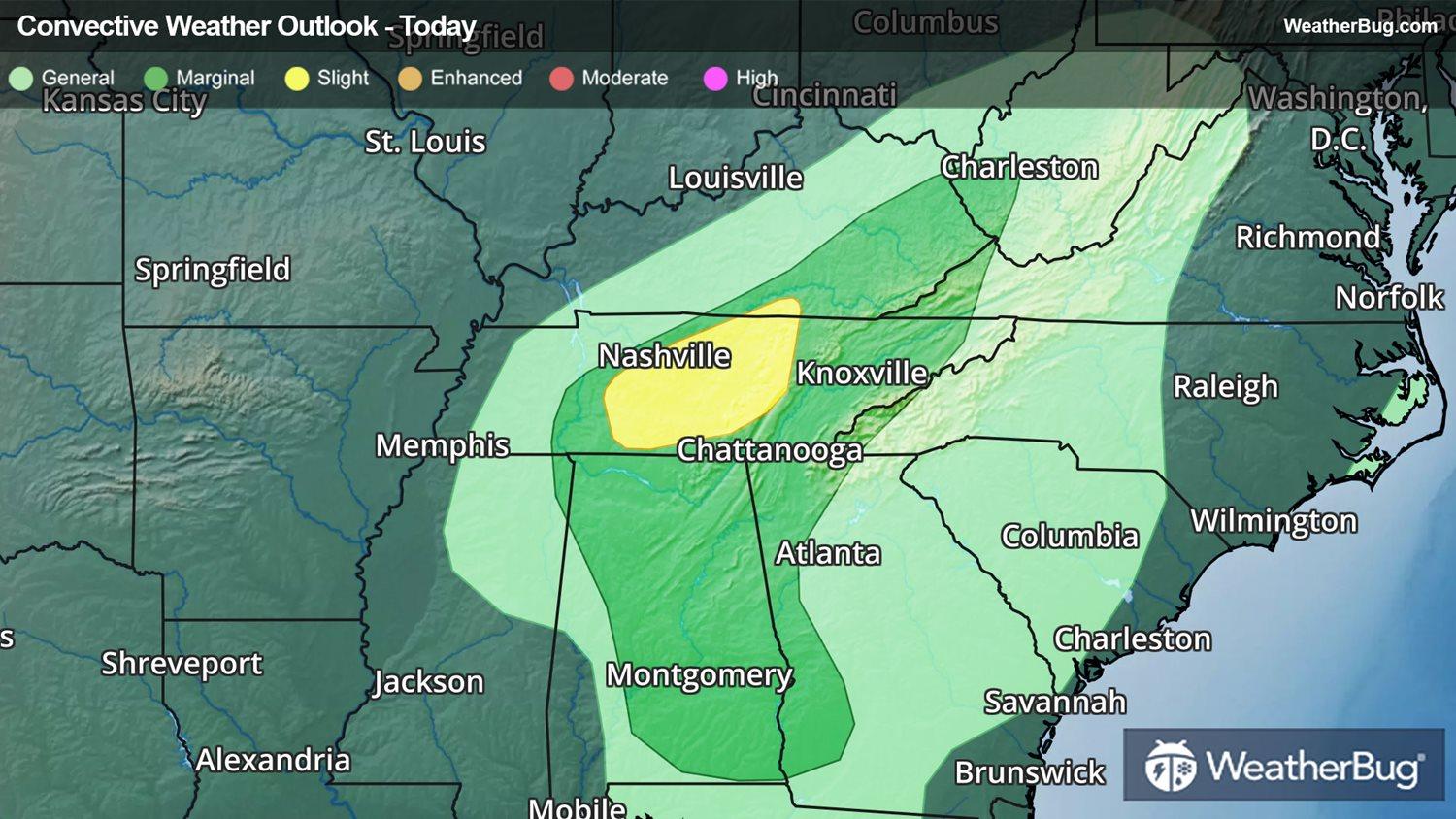
The government's Storm Prediction Center has issued a small Slight Risk, or 2 out 5 on the severe weather probability scale, almost entirely across portions of central Tennessee. This includes the cities of Nashville and Murfreesboro, Tenn.
A larger Marginal Risk, or 1 out of 5 on the severe weather probability scale, is found across southwestern Georgia and Alabama northward into Appalachian Kentucky and far southwestern West Virginia. Cities such as Charleston, W.V., Knoxville, Tenn., and Birmingham, Ala. are included in this area.
Make sure to know the difference between a watch and a warning should they become issued. A watch means that conditions are favorable for severe weather to occur and to be on alert for any rapidly changing conditions. A warning means that severe weather is imminent, and you should act fast to remain safe.
The best way to remain safe is to stay prepared and informed about your local weather. Have a severe weather kit packed with a battery-operated radio, water and non-perishable food items should you be without power for long periods of time. Also, check the WeatherBug app frequently for any updates on today’s severe weather. Remember, “When Thunder Roars, Go Indoors!”
Showers and thunderstorms will move into the Ohio Valley during the afternoon hours as the cold front pushes eastward. Along and ahead of this front, a few thunderstorms will also develop during the afternoon hours across Tennessee and Alabama.
Aided by plenty of cold air and strong winds aloft, a few thunderstorms today will be capable of producing damaging winds and hail. A few tornadoes cannot be ruled out either.
The government's Storm Prediction Center has issued a small Slight Risk, or 2 out 5 on the severe weather probability scale, almost entirely across portions of central Tennessee. This includes the cities of Nashville and Murfreesboro, Tenn.
A larger Marginal Risk, or 1 out of 5 on the severe weather probability scale, is found across southwestern Georgia and Alabama northward into Appalachian Kentucky and far southwestern West Virginia. Cities such as Charleston, W.V., Knoxville, Tenn., and Birmingham, Ala. are included in this area.
Make sure to know the difference between a watch and a warning should they become issued. A watch means that conditions are favorable for severe weather to occur and to be on alert for any rapidly changing conditions. A warning means that severe weather is imminent, and you should act fast to remain safe.
The best way to remain safe is to stay prepared and informed about your local weather. Have a severe weather kit packed with a battery-operated radio, water and non-perishable food items should you be without power for long periods of time. Also, check the WeatherBug app frequently for any updates on today’s severe weather. Remember, “When Thunder Roars, Go Indoors!”