Back to Now Forecast
Strong Winds in the Springtime
March 12, 2026 at 07:36 AM EDT
By WeatherBug Meteorologist, Christian Sayles
Did you know that high winds are not only devastating in a thunderstorm but can be devastating on a sunny day too? The changeover from winter to spring brings many challenges, but one that is often talked about is high winds.
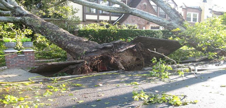
More often than not, strong to severe thunderstorms produce winds capable of rendering loose objects as projectiles. In fact, strong enough wind gusts such as those ranging between 40 to 50 mph can even topple trees and phone lines should they be loose. More significant damage can occur when winds such as straight-line winds produce near or above 100 mph wind speeds.
Even when a storm has passed and high pressure builds over the region, this does not mean wind safety becomes irrelevant. In fact, when high pressure departs and another disturbance approaches, winds can shift from tranquil to threatening in a moment’s notice.
So, what should you do if wind alerts are issued for your area? Well, one of the best ways to stay prepared is by know the following alerts should they be issued:
- Wind Advisory- This is one advisory that appears frequently no matter where you find yourself. This is issued when winds are expected to be strong, but not strong enough to cause widespread damage. This can differ depending on location, but typically when winds reach thresholds where local damage can be observed. Make sure to secure those loose objects!
- High Wind Watch/Warning- When a High Wind Watch is issued, that means that strong, sustained winds are possible, but a High Wind Warning means that strong winds and gusts are happening and to be mindful if travelling. These winds are capable of causing widespread damages if objects are not secured. They can even cause your car to sway should you caught in crosswinds.
- Dust Storm Warning- This alert is issued whenever visibility is reduced to a half of a mile or less from blowing dust or sand, as well as winds greater than 30 mph are detected. Driving during a dust storm is never recommended.
- Severe Thunderstorm Watch/Warning- When a Severe Thunderstorm Watch is issued, severe thunderstorms capable of producing damaging winds 58 mph or high and hail 1 inch or larger will be possible. When a Severe Thunderstorm Warning is issued, severe thunderstorms have been observed and danger of winds greater than 58 mph or hail 1 inch or larger is imminent.
- Gale Warning- This type of alert is typically issued for areas along coastal regions where in the next 36 hours from being issued can expected to see either sustained winds 39 to 55 mph or frequent gusts 39 to 55 mph. Make sure to have boats and/or items secured.
- Hurricane Force Wind Warning- Differing from a Hurricane Warning, this coastal alert states that in the next 36 hours sustained winds of 74 mph or frequent gusts of 74 mph or higher lasting for 2 hours or more are expected. Again, make sure to batten down the hatches should this be issued for your location.
There are some additional things to keep in mind should you be caught in dangerous high winds. Before a windy day, make sure you trim tree branches, secure loose objects outside, identify a place or area to shelter in such as a sturdy building or a basement of a home, update your emergency kit with fresh water and supplies and compose a list of items that need to be locked away or tied down should high winds come breezing through. If power lines have been knocked down, stay away from them and contact your local authorities so the right personnel can take care of them.
Source: National Weather Service
Image: A tree knocked over after a storm produced high winds. (provided by PublicDomainPictures via Pixabay.com)