


Disorganized Two Could Still Become A Tropical Storm Tonight or Tuesday
Disorganized Tropical Depression Two may become the season’s second named storm late tonight or Tuesday. This would be the first named storm since Arthur in mid-June.
A Tropical Storm Watch remains in effect from the Ochlockonee River in Florida to the Jefferson-Plaquemines Parish border in Louisiana. A watch means that tropical storm-force conditions are possible in the watch area in the next 24 to 48 hours.
A Storm Surge Watch is in effect from the Gulf Coast near the Alabama-Florida border to the Mouth of the Mississippi River along the Louisiana coast.
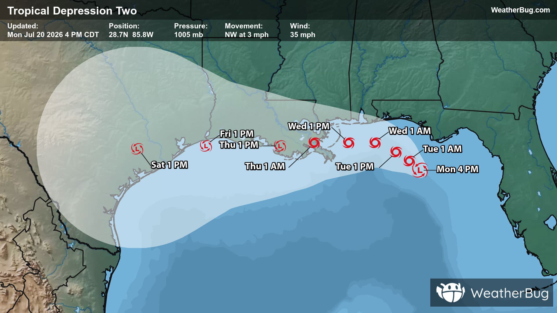
As of 4 p.m. CDT/5 p.m. EDT, Tropical Depression Two was located near 28.7N and 85.8W, or about 105 miles south of Panama City, Fla., and 195 miles southeast of Mobile, Ala. Two has top sustained winds of 35 mph and is drifting northwest at 3 mph. The depression has a minimum central pressure of 1005 mb, or 29.68 inches of mercury.
Tropical Depression Two is battling an unfavorable environment aloft. This will likely remain a common occurrence throughout its life, with a limited time to intensify to a tropical storm. If it were to become the Atlantic’s next named storm tonight or Tuesday, it would be given the name “Bertha.”
Two will move erratically along the southern edge of a large area of high pressure expanding southward across the Deep South and Gulf Coast. This will mean two will generally move to the northwest through tonight before turning west-northwest Tuesday and Wednesday. This track will keep Two’s center close to the eastern and central Gulf Coast until midweek, with a possible landfall in Louisiana on Wednesday night or Thursday morning.
Intermittent squally rain bands spinning around Two may produce locally heavy rainfall and tropical storm-force gusts along parts of the Gulf Coast this week. The central and western Florida Panhandle to southeastern Louisiana will have the greatest risk for gusts exceeding 39 mph and locally heavy rainfall totals of 1 to 3 inches. A few spots could be drenched by 4 to 5 inches in far southeastern Louisiana near the depressions track. If you approach a road covered in water, it is best to, “Turn Around, Don’t Drown!”
If the depression were to intensify to a tropical storm, a storm surge of 1 to 3 feet could be a common occurrence along the Gulf Coast. A storm surge of 2 to 4 feet will be possible from the Mouth of the Mississippi River to Morgan City, La.
Two is forecast to hug or move over the Louisiana Gulf Coast and Upper Texas Gulf Coast Thursday and Friday. This will lead to Two weakening or dissipating completely by week’s end.
It is time to prepare for the hurricane season. Create a hurricane evacuation box now, before the storm, with bottled water, extra cell phone chargers, food and clothing. Scope out multiple different evacuation routes in case your preferred route is blocked or traffic is jammed.