


T.D. Two Likely to Strengthen to Tropical Storm Today
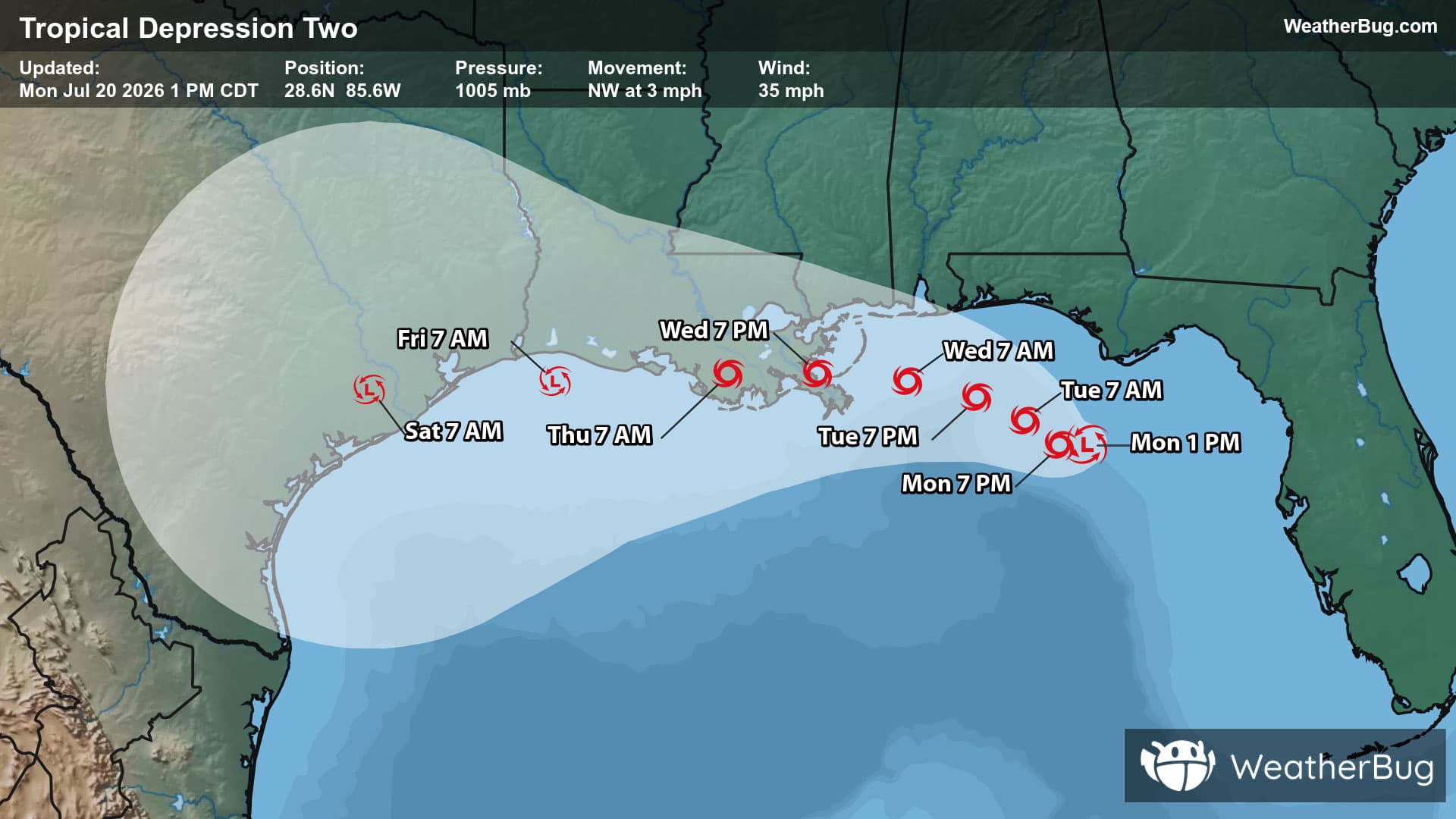
Tropical Depression Two continues to slowly churn in the northeastern Gulf, likely becoming the Atlantic’s second named storm later today. This will be the first storm named since Arthur back in mid-June.
A Tropical Storm Watch is in effect from the Ochlockonee River in Florida to the Jefferson/Plaquemines Parish border in Louisiana. A watch means conditions are possible in the watch area in the next 24 to 48 hours.
A Storm Surge Watch has been issued from the Gulf Coast near the Alabama/Florida border to the Mississippi River along the Louisiana coast.
As of 1 p.m. CDT/2 p.m. EDT, Tropical Depression Two was located near 28.6N and 85.6W, or about 110 miles south of Panama City, Fla. and 210 miles southeast of Mobile, Ala. Two is packing top sustained winds of 35 mph and is moving towards the northwest at 3 mph. The depression has a minimum central pressure of 1005 mb, or 29.68 inches of mercury.
Two will gradually intensify today after dealing with streams of dry air affecting its development. Later on Tuesday, Two will have more favorable conditions to intensify in the northern Gulf. However with its current track, interaction with land along the central Gulf Coast may limit how intense this storm becomes. Despite this, Two will be interacting with very warm waters, which will help it likely develop into a tropical storm later today and be coined the name, “Bertha”.
Two will crawl towards the northwest today before turning to the west-northwest on Tuesday. Tropical storm-force winds and conditions will occasionally batter the northeastern and central Gulf over the coming days. Residents in the Florida Panhandle, coastal Alabama and Mississippi, and eastern and southeastern Louisiana will need to be prepared for torrential rain and gusty winds at least through the midweek.
The peak rain totals associated with Two will likely remain in the Gulf, however, torrential rain will still be common with 2 to 4 inches likely by midday Wednesday for the Florida Panhandle. Where Two intends to make landfall, likely between Marsh Island and Lake Pontchartrain and in the Chandeleur Sound in Louisiana, rain totals of 2 to 4 inches are likely with localized amounts of 8 inches possible. With all this heavy rain coupled with the low-lying areas, flooding will be likely. Remember, if you approach a roadway covered in water, it is best to “Turn Around, Don’t Drown!”
Two will bring storm surges of 1 to 3 feet possible near and north of its circulation but could get up to 2 to 4 feet near the mouth of the Mississippi River in Louisiana to the Alabama and Florida border. Surges will occur over the Florida Panhandle first before shifting westward along the Gulf Coast as Two continues its track through the midweek. Tropical storm-force winds, or those greater than 39 mph, are likely to occur in waves along the northeastern to central Gulf Coast as well.
With an area of high pressure set to strengthen and expand from the Southeast and Deep South into the Southwest, Two may be forced to shift to the west-southwest in the second half of the week. This could bring tropical storm-force condition, torrential rain and storm surges into the Upper Texas Gulf Coast. However, exact track and potential impacts remain highly uncertain.
It is time to prepare for the hurricane season. Create a hurricane evacuation box now, before the storm, with bottled water, extra cell phone chargers, food and clothing. Scope out multiple different evacuation routes in case your preferred route is blocked or traffic is jammed.