Back to forecast
The Jet Stream: Our Guiding Winter Weather Pattern
February 23, 2023 at 03:57 PM EST
By WeatherBug Sr. Meteorologist, Chad Merrill
The weather term gets tossed around everywhere…radio, television, newspaper and online articles but what is the jet stream and what instigates its development?
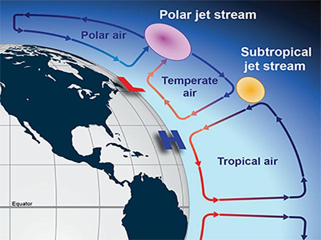
It’s exactly what the term suggests….a stream of air that can travel as fast as a jet! The reason it varies in placement and strength is due to temperature differences. Air rises year-round over the warm equator and as it moves towards the poles (because it has to go somewhere), encounters colder air seeping south from the North Pole. This helps to foster a subtropical jet stream, which transports moisture to a location, and the polar jet stream is the northern counterpart that dislodges cold, dry air.
The big contrast in temperature between the air in the wake of the polar jet stream and warm, more humid air surging north from the subtropical jet stream often fuel powerful cold fronts. A prime example was the front responsible for the major winter storm across the northern tier last week.
Northern Hemisphere winter is when the temperature difference between the North Pole and equator is the greatest due to significant loss of solar heating at the North Pole. This is why cold fronts in December, January and February, guided by a healthy, strong jet stream, can plow through southern states and put a significant dent in temperatures. The jet stream helps to dislodge the cold air and the faster the winds aloft, the better chance a cold front will push into a subtropical climate.
As the North Pole warms in the summer, temperature differences aren’t nearly as significant between it and the equator. That explains the lack of cold fronts that cross the U.S. in July and August. An anemic jet stream won’t have the power to push into southern states.
What’s the jet stream forecast going forward through this winter? A recent Stratospheric Warming Event will likely dislodge cold air from the North Pole towards Europe, Asia and eventually the U.S. Therefore, with an increasing temperature gradient developing between air over the equator going pole-bound and a weaker polar vortex sending cold air equator-bound, the jet stream winds will intensify. The orientation of the jet stream will become more north to south over time as the cold air spills south.
The opposite usually happens with a strong stratospheric polar vortex. Less cold air is released from the North Pole and the jet stream becomes zonal or west to east. In this case, much of the Northern Hemisphere’s temperatures are warmer than average due to the lack of dislodged cold outbreaks.
Once spring rolls into summer, watch the jet stream winds decrease and migrate towards the North Pole. During the interim, the jet stream can cut-off if a punch of cold air moves south and then quickly retreats. These “cut-off” low pressure systems stall and can produce rain over the same location for several days on end. They are most common in the spring and occasionally the fall season.
Stay with the WeatherBug news section for the latest on any major weather systems crossing the U.S. Have your WeatherBug app handy for the latest forecast and any severe weather watches and warnings issued for your area.
---
Story Image: A cross sectional view of the traditional subtropical and polar jet streams. (Courtesy of NOAA)