Back to forecast
This Day In History: Hurricane Opal Drenches Atlanta With Record Rain
September 29, 2020 at 11:59 AM EDT
By WeatherBug Sr. Meteorologist, Chad Merrill
The Southeast is notorious for getting slammed with tropical systems in the fall. The peak of the Atlantic hurricane season can bring tropical storms and hurricanes that produce downpours and winds in September and early October. As a matter of fact, 25 years ago, a powerful hurricane swept into the Southeast and added to one city’s weather records.
July is Atlanta’s wettest month with an average of 5.27 inches of rain while October is the second driest month with only 3.41 inches. On occasion, a tropical system can throw a wrench into the ATL’s rainfall distribution. On October 4, 1995, monstrous Hurricane Opal did just that.
The tropical wave that eventually became Hurricane Opal initially formed off the African coast on September 11. The weak low pressure peacefully pushed across the Atlantic into the Caribbean over the next two weeks. It didn’t become a tropical depression until September 27 when it rolled off the Yucatan Peninsula southeast of Cozumel, Mexico. The depression became a tropical storm by September 30 in the southern Gulf of Mexico. A big Central U.S. trough helped push the storm north through the Gulf of Mexico where it moved over very warm water and grew into a major Category Four storm with maximum sustained winds of 150 mph.
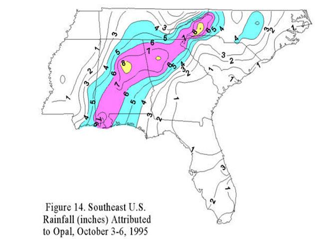
Opal was still a major Category Three Hurricane when it made landfall at 5 p.m. on October 4 near Pensacola Beach, Fla. As the storm swept north, it rocked through Atlanta, producing wind gusts up to 69 mph that left 300,000 residents in the dark. Atlanta also got soaked with 6.68 inches of rain, demolishing the city’s former all-time single day rainfall record by more than one inch.
Atlanta wasn’t the only city that took a hit with Opal. Brewtown, Ala., tallied 19.42 inches, Pensacola, Fla., got hit with 15.45 inches while Mobile, Ala., was soaked with 7.48 inches of rain. Opal also brought incredible wind gusts into the Southeast, with a 144-mph gust clocked at Hurlburt Field, Fla., a 79-mph gust at Pensacola Regional Airport in Florida while Mobile, Ala., had a peak gust of 66 mph.
Opal dissipated to a low pressure as it dashed north through the eastern Tennessee and Ohio valleys on October 5. Its main impacts transitioned to heavy rainfall. The southern Appalachians got drenched with more than 10 inches while the Ohio and Tennessee valleys saw 3 to 6 inches.
The severe winds and flooding contributed to nine deaths, including at least two in Atlanta from fallen trees. Opal destroyed many homes from Navarre Beach to Destin, Fla. The storm’s total damage in today’s figures was $3.4 billion.
“Opal” was the first storm to be assigned a name beginning with “O” since naming began in 1950. Since it was a deadly and costly storm, Opal had to be retired from the list of named storms after the 1995 Atlantic Hurricane Season. Since each list of names is repeated every six years “Olga” replaced “Opal” in the 2001 Atlantic Hurricane Season. Olga hasn’t been retired just yet; It appears next in the 2025 list of named storms. The only other “O” storm to be retired was “Otto” in 2016. “Owen” replaces Otto and will appear next in the 2022 list of named storms.
--------
Story Image: Rainfall amounts attributed to Hurricane Opal in early October 1995.
July is Atlanta’s wettest month with an average of 5.27 inches of rain while October is the second driest month with only 3.41 inches. On occasion, a tropical system can throw a wrench into the ATL’s rainfall distribution. On October 4, 1995, monstrous Hurricane Opal did just that.
The tropical wave that eventually became Hurricane Opal initially formed off the African coast on September 11. The weak low pressure peacefully pushed across the Atlantic into the Caribbean over the next two weeks. It didn’t become a tropical depression until September 27 when it rolled off the Yucatan Peninsula southeast of Cozumel, Mexico. The depression became a tropical storm by September 30 in the southern Gulf of Mexico. A big Central U.S. trough helped push the storm north through the Gulf of Mexico where it moved over very warm water and grew into a major Category Four storm with maximum sustained winds of 150 mph.
Opal was still a major Category Three Hurricane when it made landfall at 5 p.m. on October 4 near Pensacola Beach, Fla. As the storm swept north, it rocked through Atlanta, producing wind gusts up to 69 mph that left 300,000 residents in the dark. Atlanta also got soaked with 6.68 inches of rain, demolishing the city’s former all-time single day rainfall record by more than one inch.
Atlanta wasn’t the only city that took a hit with Opal. Brewtown, Ala., tallied 19.42 inches, Pensacola, Fla., got hit with 15.45 inches while Mobile, Ala., was soaked with 7.48 inches of rain. Opal also brought incredible wind gusts into the Southeast, with a 144-mph gust clocked at Hurlburt Field, Fla., a 79-mph gust at Pensacola Regional Airport in Florida while Mobile, Ala., had a peak gust of 66 mph.
Opal dissipated to a low pressure as it dashed north through the eastern Tennessee and Ohio valleys on October 5. Its main impacts transitioned to heavy rainfall. The southern Appalachians got drenched with more than 10 inches while the Ohio and Tennessee valleys saw 3 to 6 inches.
The severe winds and flooding contributed to nine deaths, including at least two in Atlanta from fallen trees. Opal destroyed many homes from Navarre Beach to Destin, Fla. The storm’s total damage in today’s figures was $3.4 billion.
“Opal” was the first storm to be assigned a name beginning with “O” since naming began in 1950. Since it was a deadly and costly storm, Opal had to be retired from the list of named storms after the 1995 Atlantic Hurricane Season. Since each list of names is repeated every six years “Olga” replaced “Opal” in the 2001 Atlantic Hurricane Season. Olga hasn’t been retired just yet; It appears next in the 2025 list of named storms. The only other “O” storm to be retired was “Otto” in 2016. “Owen” replaces Otto and will appear next in the 2022 list of named storms.
--------
Story Image: Rainfall amounts attributed to Hurricane Opal in early October 1995.