Back to forecast
Thunderstorms Take Aim on Texas and the Deep South
January 29, 2025 at 02:45 PM EST
By WeatherBug Meteorologist, Mark Paquette
A large upper-level disturbance found over the southern Rockies today will continue to creep eastward and cause a severe weather outbreak for the Southern Plains and Deep South tonight and later this week.
After causing much needed rain and mountain snow for southern California this past weekend and earlier this week this system will continue its eastward trek today. Though it will continue to be fairly starved for moisture today, very late today and tonight it will begin to tap into Gulf of Mexico moisture, and this will help form the beginnings of a severe weather outbreak.
Today will see showers and a few thunderstorms from over Texas as well as snow in the southern Rockies. Winter Storm Warnings are in effect for the Rocky Mountains of northern New Mexico through Thursday, with a foot of snow possible at elevations over 8,000 feet. Winter Weather Advisories are in place for the San Juan Mountains of southwest Colorado and other high elevation locations in New Mexico over 5,000 feet.
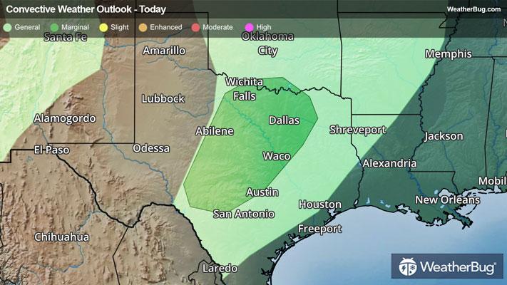
As the system continues to slowly head eastward, its main impact will become severe thunderstorms. The government's Storm Prediction Center has placed a Marginal Risk over a large portion of interior Texas and a small portion of extreme southern Oklahoma late today. A flow of air off the Gulf of Mexico moisture will get pulled inland over Texas and, at the same time, winds aloft will be strong from the west and southwest. This turning off the wind with height will be a trigger for possible severe thunderstorm formation with strong wind gusts and even perhaps a few tornadoes being the main threat from these thunderstorms.
This severe weather threat will push eastward as the storm does. On Thursday, the severe weather threat will be over eastern Texas, much of Louisiana, and extreme southwest Mississippi where the government’s Storm Prediction Center has placed a Slight Risk. The main threats from this potential severe weather outbreak will continue to be strong wind gusts and a few tornadoes.
The best thing to do is to stay prepared and weather-aware, starting with knowing the difference between a watch and a warning should they be issued this week. A watch means that conditions are favorable for severe weather to develop, and you need to have a plan in place for acting. However, a warning means that severe weather has been indicated and/or imminent, and you need to act fast to remain safe. When in doubt remember, “When Thunder Roars, Go Indoors!”
After causing much needed rain and mountain snow for southern California this past weekend and earlier this week this system will continue its eastward trek today. Though it will continue to be fairly starved for moisture today, very late today and tonight it will begin to tap into Gulf of Mexico moisture, and this will help form the beginnings of a severe weather outbreak.
Today will see showers and a few thunderstorms from over Texas as well as snow in the southern Rockies. Winter Storm Warnings are in effect for the Rocky Mountains of northern New Mexico through Thursday, with a foot of snow possible at elevations over 8,000 feet. Winter Weather Advisories are in place for the San Juan Mountains of southwest Colorado and other high elevation locations in New Mexico over 5,000 feet.
As the system continues to slowly head eastward, its main impact will become severe thunderstorms. The government's Storm Prediction Center has placed a Marginal Risk over a large portion of interior Texas and a small portion of extreme southern Oklahoma late today. A flow of air off the Gulf of Mexico moisture will get pulled inland over Texas and, at the same time, winds aloft will be strong from the west and southwest. This turning off the wind with height will be a trigger for possible severe thunderstorm formation with strong wind gusts and even perhaps a few tornadoes being the main threat from these thunderstorms.
This severe weather threat will push eastward as the storm does. On Thursday, the severe weather threat will be over eastern Texas, much of Louisiana, and extreme southwest Mississippi where the government’s Storm Prediction Center has placed a Slight Risk. The main threats from this potential severe weather outbreak will continue to be strong wind gusts and a few tornadoes.
The best thing to do is to stay prepared and weather-aware, starting with knowing the difference between a watch and a warning should they be issued this week. A watch means that conditions are favorable for severe weather to develop, and you need to have a plan in place for acting. However, a warning means that severe weather has been indicated and/or imminent, and you need to act fast to remain safe. When in doubt remember, “When Thunder Roars, Go Indoors!”