Thunderstorms to Rumble Across the Plains, Atlantic Coast
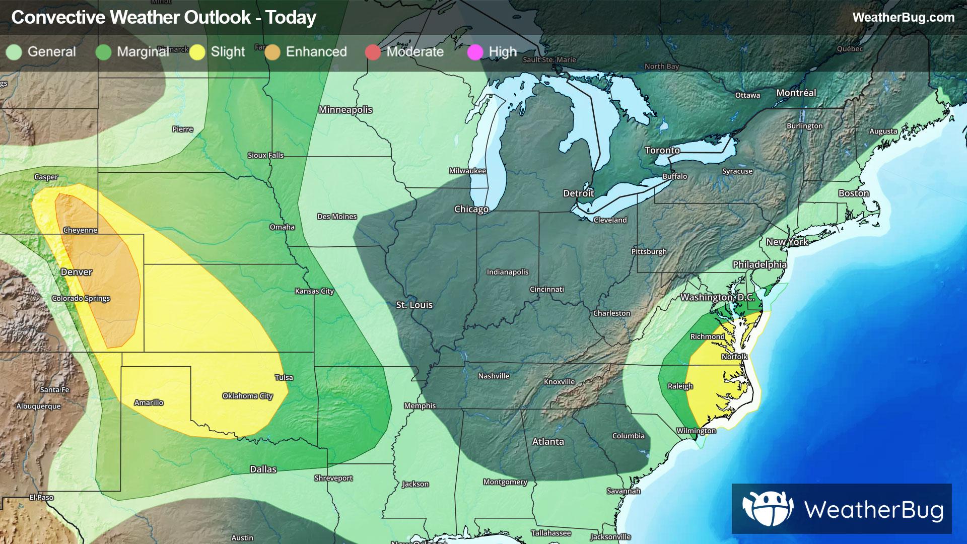
There are a pair of areas to watch in terms of severe thunderstorms today: one is along the Atlantic coast from the southern Mid-Atlantic southward to the Outer Banks and adjacent areas just inland in North Carolina. The other is a large portion of the central and southern Plains.
The government's Storm Prediction Center has a Slight Risk (level 2 of 5) from eastern North Carolina northward to the southern Delmarva Peninsula. The second zone area to watch for severe weather today extends from southeastern Wyoming into western and central Kansas and also includes the panhandle region of Texas and much of Oklahoma as well as eastern Colorado. An Enhanced Risk (level 3 of 5) is found in southeastern Wyoming and eastern Colorado with a larger area of Slight Risk (again, level 2 out of 5) found from southeastern Wyoming southeast to northern Texas and much of Oklahoma.
Cities such as Denver, Oklahoma City, Fort Collins, Colo., Virginia Beach, Va., and Wichita, Kan., will need to keep a watchful eye to the sky for threatening weather today.
Scattered damaging wind gusts up to 70 mph, isolated very large, destructive hail in excess of baseball size, and a brief tornado or two will be possible for portions of the central and southern Plains. Damaging wind gusts and perhaps a brief tornado may occur with storms in the Mid-Atlantic and in eastern North Carolina.
Heavy, flooding rainfall will be a byproduct of intense thunderstorm activity as well. One to 2 inches falling in a short time could foster urban and poor drainage flooding, particularly where excess runoff will overwhelm storm drains. If you approach a road covered in water, it is best to “Turn Around, Don’t Drown!”
Make sure to know the difference between a watch and a warning should they be issued. A "watch" means that conditions are favorable for severe weather to occur, and to be on alert for any rapidly changing conditions. A "warning" means that severe weather is imminent, and you should act fast to remain safe.
The best way to remain safe is to stay prepared and informed about your local weather. Have a severe weather kit packed with a battery-operated radio, water, and non-perishable food items. Also, check the WeatherBug app frequently for any updates on today's severe weather. Remember, "When Thunder Roars, Go Indoors!"