
Today's Weather Outlook

Today will be soggy across the Mid-Mississippi Valley, while storms will continue to wreak havoc across the Dakotas, northern New England and the Deep South.
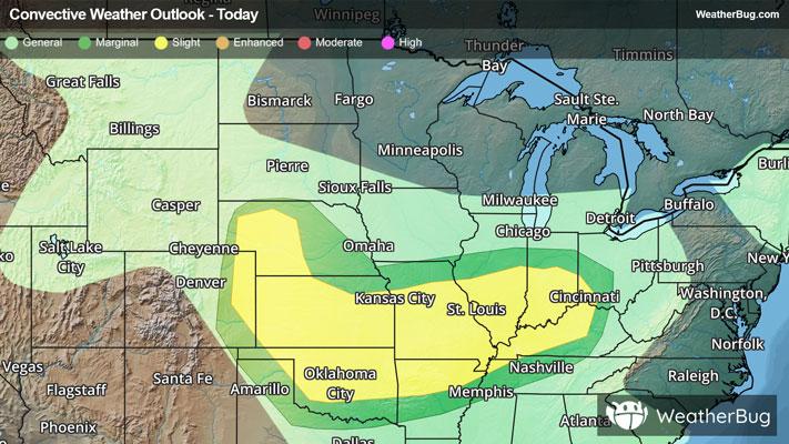
The biggest trouble spot in the country will be across the Mid-Mississippi Valley from Iowa and Missouri into Indiana. Here, showers and thunderstorms will ruin any Father’s Day plans. A few of the storms could even turn severe, although flooding remains the biggest threat of the day.
Another disturbance marching along behind the big Mississippi Valley storm is expected to bring scattered thunderstorms from the Front Range in Montana across the Dakotas. Some of the moisture and energy from this system will help pep up thunderstorms closer to the Mississippi Valley.
A cold front with no intention to move will remain across the Deep South, bringing soaking rainfall from Louisiana to Georgia. Meanwhile, another low pressure system will stubbornly sit across northern New England, bringing showers from upstate New York to Maine.
Otherwise, Father’s Day will be perfect for a trip to the ballgame or a round of golf anywhere from the West Coast to Texas, and from Minnesota and Wisconsin to the Mid-Atlantic.
Today will also mark the first day of summer, but residents of the Dakotas and much of the northern tier may be a bit skeptical. Highs only in the 60s to lower 70s will be found from eastern Montana and the Dakotas all the way to northern New England. Upper 70s and 80s will be found from the Pacific Northwest to the central Plains and into the Mid-Atlantic.
A few lower 90s will add a bit of heat to the air from the Great Basin to the Mid-South, as well as across the Tennessee Valley into the southern Mid-Atlantic. The hottest temperatures on will be found from the Desert Southwest to western Texas and Oklahoma, where readings are likely to top the century mark.