Weekend Weather Outlook
Mother Nature has no plans to switch up the weather pattern as we head into August.
Today
August kicks off with an expansive low pressure system in the Midwest, which will see widespread cloud cover, showers, and even thunderstorms throughout the day. Heavy downpours dumping rain totals of 1 to 3 inches of rain will be common, bringing a potential for dangerous flash-flooding.
A stalled cold front hanging over the Southeast will bring scattered cells to the region, where storms will be more widespread later in the day. In the afternoon hours, isolated showers will pop up in New England. Meanwhile, in the Western U.S., monsoonal moisture will help to initiate isolated showers and thunderstorms in parts the Desert Southwest and the Mountain West. The Pacific Northwest could also see a few showers throughout the day.
Meanwhile, the rest of the West Coast, along with much of the interior East will stay high and dry with clear or partly cloudy skies.
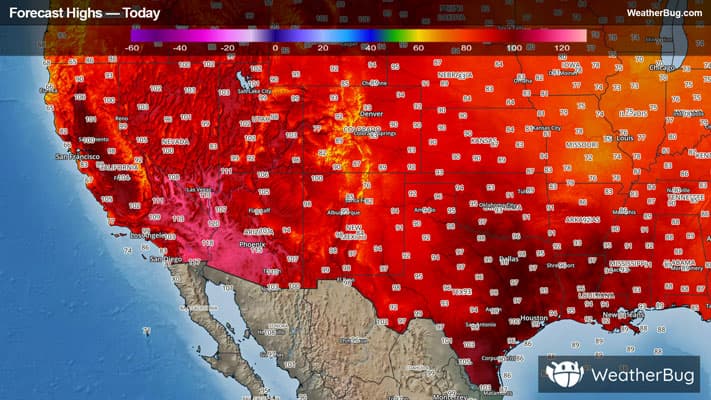
Highs in the Northeast will stay cool, as highs will range from the upper 60s into the 80s. The Midwest, along with the Central Plains will be warmer, where high are expected to be in the 80s and 90s. The South along with the High Plains will sizzle, with highs in the 90s and triple digits. Meanwhile, the Appalachian Spine will see highs in the 60s and 70s.
In the West, temperatures will range from the 80s to well over 100 degrees, where the hottest temperatures will be in the Desert Southwest. The higher elevations can expect temperatures in the 50s and 60s.
Sunday
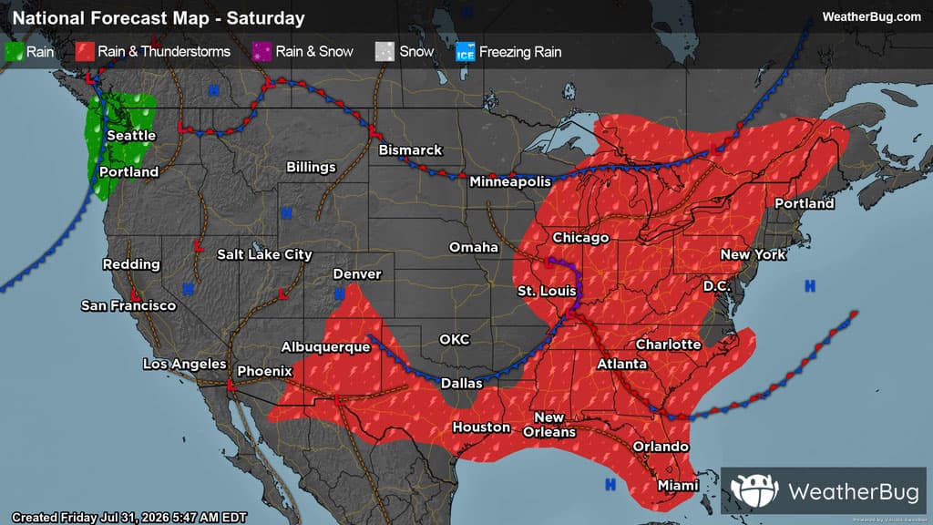
A couple low pressure systems will bring active weather to the eastern U.S. on Sunday.
One of the systems will be over the Ohio Valley while the other will track into Quebec, Canada. The combination of these will bring a rain-soaked, stormy day east of the Mississippi River.
Around 1 to 2 inches of rain is forecast under the heaviest batches of rain, but the Mid-Atlantic and southern New England region will be the exception with a mostly dry day.
Monsoonal moisture could help form isolated to widely scattered thunderstorms over Arizona, New Mexico, and Colorado during the afternoon and evening hours, otherwise it will be hot and dry. A weak trough could also help produce a few showers or thunderstorms across the southern Texas Border and Texas Gulf Coast.
Washington state and northwestern Oregon could receive some mist or light showers on Sunday, but much of the central and western U.S. will be dry.
The Midwest, the eastern portion of the Plains, as well as the Ohio Valley, Great Lakes, Northeast, New England and Mid-Atlantic will all be in the 70s and 80s. Ninety-degree temperatures can be found in the Southeast, portions of the Gulf Coast states, and central and southern Plains.
Triple digit temperatures are forecast for a portion of the northern Plains, Great Basin, southern Texas, and Desert Southwest. Cooler 70s and 80s are expected over the Pacific Northwest and coastal California. Even some 60s can be felt in the higher elevations in the northern Rockies and Cascades.