
Tornado Alley Storms Roar This Weekend
Tornado Alley returns to form this weekend and beyond as multiple rounds of severe weather hound the region.
Today, strong upper-level winds will aid a strengthening but stagnant storm system near the Texas Panhandle. An inflow of humid air will be reinforced by the system, wrapping in increasing moisture and heat to the central Plains. As a result, severe storms will rally each day after sunlight heats the surface each afternoon and evening. All severe weather hazards will be in play.
A Severe Thunderstorm Watch has been issued from southern Illinois to central Kentucky. This includes Evansville, Ind., Cincinnati, Ohio, and Louisville, Ky.
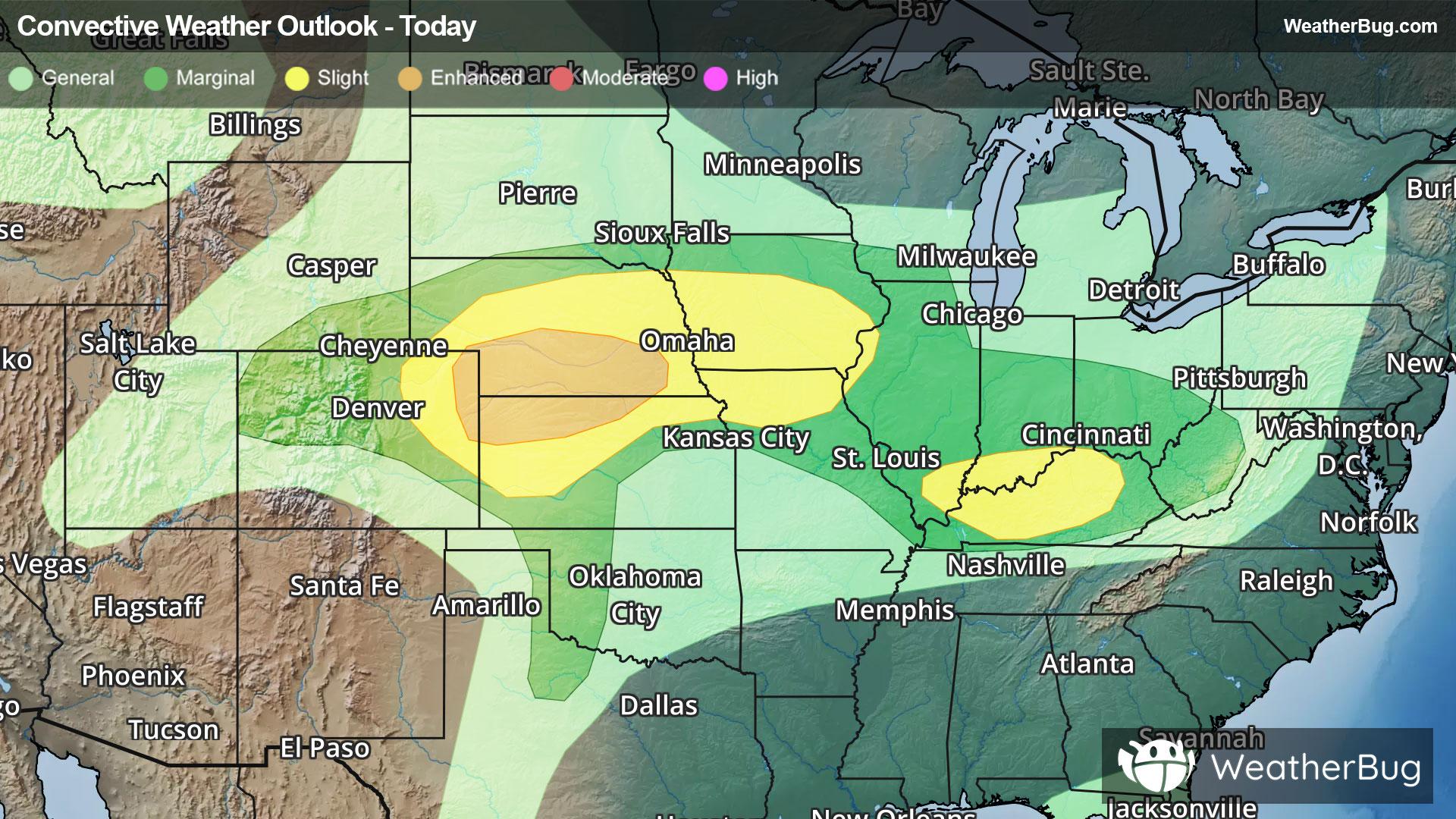
The government’s Storm Prediction Center has issued an Enhanced Risk, or a 3 out of 5 on the severe weather probability scale, for parts of southern Nebraska, northwestern Kansas, and far northeastern Colorado. Towns including Kearney and North Platte, Neb., will be at risk for widely scattered hailstorms and damaging winds, as well as isolated tornadoes, within supercells or severe thunderstorm lines.
Additionally, there are two Slight Risks, a 2 out of 5 on the severe weather probability scale, where severe storms are expected to be more isolated in nature. One covers northeastern Colorado through central Iowa and northern Missouri, where cities such as Omaha and Lincoln, Neb., as well as Des Moines and Sioux City, Iowa, could observe hail with diameters of two inches or more or damaging winds up to 75 mph.
The other Slight Risk area holds central Kentucky and southern Indiana, including Lexington and Louisville, Ky. Stray instances of large hail, damaging winds, and even a tornado or two will be possible this morning from convection that survived the overnight hours.
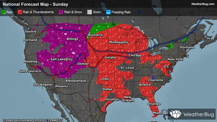
Heading into the latter half of the weekend, the low pressure system saunters northeastward and speeds up the inflow of humid and unstable Gulf air into the north-central Plains, ready to launch with a sharpening frontal collision. As this occurs, tornadic ingredients will align more cleanly as supercells launch and cluster about the area, with a few stronger tornadoes possible.
Another Enhanced Risk is posted over eastern Nebraska through far southwestern Minnesota on Sunday, threatening folks residing in Sioux Falls, S.D., Sioux City, Iowa, and Grand Island, Neb. A Slight Risk also spans from Minnesota and Wisconsin southwestward into Oklahoma, containing St. Paul and Minneapolis, Minn., as well as Omaha and Lincoln, Neb.
Entering the workweek, the grasp of severe weather is only expected to expand as the low pressure system's cold front organizes and finally treads eastward. Ahead of and along the front, many supercells, and later, severe thunderstorm lines, will ignite across Tornado Alley. At their most intense, hail of two to four inches in diameter or greater, damaging winds exceeding 75 mph, and tornadoes, with a few intense spin-ups, are likely with scattered severe thunderstorms.
Monday’s Enhanced Risk currently covers ground from north-central Oklahoma through central Iowa, while a vast Slight Risk stretches from north-central Texas through much of Michigan.
Make sure to know the difference between a watch and a warning should they be issued. A watch means that conditions are favorable for severe weather to occur, and to be on alert for any rapidly changing conditions. A warning means that severe weather is imminent, and you should act fast to remain safe.
The best way to remain safe is to stay prepared and informed about your local weather. Have a severe weather kit packed with a battery-operated radio, water, and non-perishable food items should you be without power for long periods of time. Also, check the WeatherBug app frequently for any updates on today’s severe weather. Remember, “When Thunder Roars, Go Indoors!”