Ida Poses Major Flood Risk Across South, East
Ida strengthened rapidly into a high end Category 4 major hurricane before making landfall near Port Fourchon, La., at 11:55 a.m. CDT Sunday. Although Ida is now a tropical depression, the threat for flooding rains remains extremely high.
As of 10 p.m. CDT, Ida was located near 33.3 N, 89.5 W, or about80 miles north-northeast of Jackson, Miss. Ida had maximum sustained winds of 35 mph and was moving northeast at 10 mph, with a minimum central pressure reading of 998 mb, or 29.47 inches of mercury.
Even though Ida has weakened to a tropical depression, torrential rain and gusts of 35 to 40 mph are possible near the core of the storm.
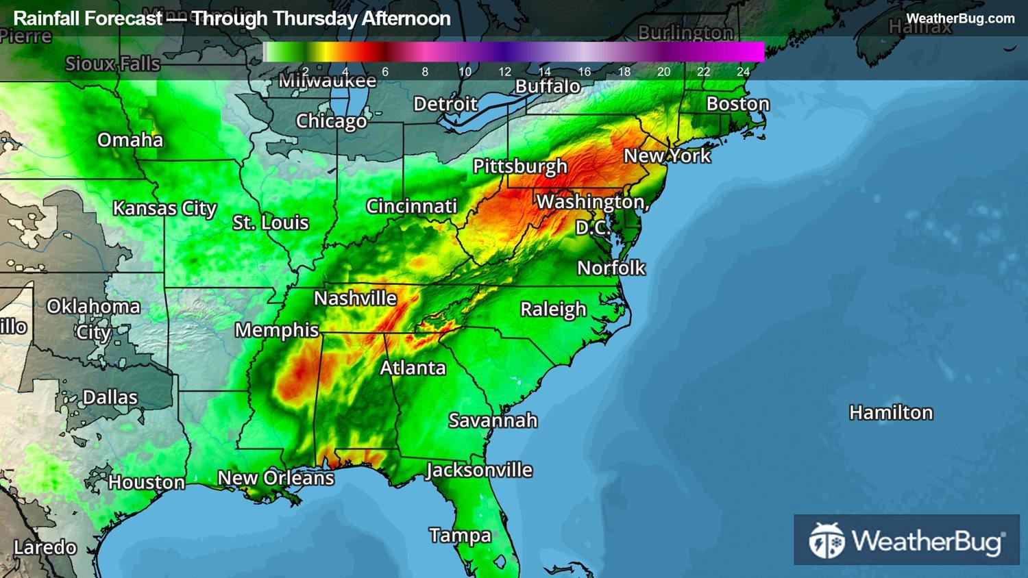
On Tuesday, the remnants of Ida should continue tracking northeast through the Tennessee Valley, bringing the potential for 2 to 4 inches of rain from Atlanta and Nashville, Tenn. to the southern Appalachians. Aided by the rotation from what's left of Ida, a few short-lived tornadoes are also possible from the Florida Panhandle to western Georgia.
By early Wednesday, the remnants of Ida are expected to interact with a frontal boundary and tranistion to a post-tropical cyclone. The frontal interaction will enhance rainfall further and widespread amounts of 3 to 6 inches of rain are possible across the northern Mid-Atlantic into southern New England.
As a result of the heavy rain falling on wet soils, Flash Flood Watches stretch from Alabama to southern New England including Nashville, Tenn., Lexington, Ky., Charleston, W.Va., Washington, D.C., Baltimore, Philadelphia, New York and Providence, R.I.
Ida battered the central Gulf Coast with winds gusts over 100 mph for much of southeastern Louisiana on Sunday. As a result, more than one million customers are still without power in Louisiana alone.
Elsewhere in the central Atlantic, there's additional tropical trouble as Tropical Storm Kate continues to push north.
As of 11 p.m. AST, Tropical Storm Kate was located at 22.7 N, 50.9 W, or about 805 miles east-northeast of the Leeward Islands. It has maximum sustained winds of 40 mph and is moving north at 10 mph. Its minimum central pressure was recorded at 1006 mb, or 29.71 inches of mercury. This system is expected to move into the Atlantic, east of Bermuda.