Back to forecast
Hurricane Fiona Racing Toward Atlantic Canada
September 23, 2022 at 12:16 PM EDT
Updated By WeatherBug Meteorologists
Hurricane Fiona continues to race toward Atlantic Canada, making a strong impact this weekend. Meanwhile, Tropical Storm Gaston is spinning near the Azores.
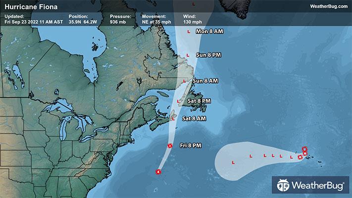
As of 11 a.m. AST/EDT, Hurricane Fiona was located at 35.9 N and 64.2 W, or 250 miles north of Bermuda and 600 miles south of Halifax, Nova Scotia. Fiona has maximum sustained winds of 130 mph, making it a Category 4 hurricane on the Saffir-Simpson Wind Scale. It is moving northeast at 35 mph and has a minimum central pressure of 936 mb, or 27.64 inches of mercury.
A Hurricane Warning is in effect for Nova Scotia from Hubbards to Brule, Prince Edward Island, Isle-de-la-Madeleine and for Newfoundland from Parson’s Pond to Francois.
A Tropical Storm Warning is still in effect for Bermuda but conditions there are rapidly improving. Warnings are also in place for Atlantic Canada from St. Andrews, New Brunswick, to west of Hubbards, Nova Scotia; from west of Brule, Nova Scotia, to Cap Madeleine, Quebec; Anticosti Island; from Sheldrake, Quebec, to north of Parson’s Pond, Newfoundland; from Boat Harbor to Hare Bay, Newfoundland and from Francois to St. Lawrence, Newfoundland.
A Tropical Storm Watch remains in effect for north of Boat Harbor, Newfoundland to West Bay, Labrador.
Fiona will race to the northeast today and weaken while tracking over cooler waters. This path will result in a heavy impact over eastern Canada's Atlantic Provinces. High winds, storm surge and heavy rainfall are expected starting late Friday into Saturday. Nova Scotia, Prince Edward Island and western Newfoundland have 3 to 6 inches of rain forecast, with localized maximum of 10 inches possible. Eastern Quebec may see 2 to 5 inches of rain while eastern Newfoundland and eastern New Brunswick may see 1 to 3 inches.
Even parts of Maine will be buffeted by strong winds on Saturday as Fiona passes by well to the east. High Wind Warnings are in effect from Bangor to Caribou, Maine eastward to New Brunswick, while central portions of Maine are covered by a Wind Advisory. Be sure to take action before going to bed tonight by securing any loose outdoor objects.
As of 3 p.m. GMT/11 a.m. EDT, Tropical Storm Gaston was located at 40.2 N and 29.1 W, or 115 miles north of Faial Island in the Central Azores. It is producing top sustained winds of 65 mph and is moving east-southeast at 7 mph. Tropical Storm Gaston has a minimum central pressure of 995 mb, or 29.39 inches of mercury.
A Tropical Storm Warning is in effect for Flores and Corvo in the western Azores and Faial, Pico, Sao Jorge, Graciosa and Terceira in the central Azores, which means tropical storm conditions are expected in the next 24 to 36 hours.
Tropical Storm Gaston will slowly move in a southerly direction today near the Azores Islands then make a sharp turn to the west this weekend. The tropical storm will start to interact will cooler waters, drier air and stronger winds aloft. As a result, it will lose its tropical characteristics over the weekend.
Gaston will bring tropical-storm-force winds, heavy rain and life-threatening surf and rip currents to the western and central Azores today and Saturday. Total rainfall accumulations of 2 to 6 inches are expected, with locally higher amounts.
While the climatological peak of hurricane season just recently passed, it is very important to still be ready for a tropical storm or hurricane should one come your way. Collect non-perishable goods and water, blankets, radios and batteries, and extra cellphone chargers into a hurricane-supply kit. Scope out multiple evacuation routes in case your preferred route is traffic-jammed or blocked.