Back to forecast
Beryl Strengthens Into a Major Hurricane, Eyes Barbados
June 30, 2024 at 05:10 PM EDT
UPDATED By WeatherBug Meteorologists
The Atlantic hurricane season is off to a hot start, with the season’s first major hurricane lurking in the west-central Atlantic. We are also watching additional tropical trouble over the next several days.
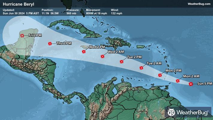
As of 8 a.m. AST, Major Hurricane Beryl was located near 10.6 N, 53.9 W, or about 420 miles east-southeast of Barbados. Containing maximum sustained winds of 115 mph, Beryl is a Major Category 3 hurricane on the Saffir-Simpson Hurricane Wind Scale. Major Hurricane Beryl was moving west at 21 mph with a minimum central pressure of 981 mb or 28.97 inches of mercury.
A Hurricane Warning is in place for Barbados, St. Lucia, St. Vincent and the Grenadines, Granada and Tobago. A Tropical Storm Warning is in effect for Martinique, with a Tropical Storm Watch posted for Dominica.
A Hurricane Warning means that hurricane conditions (sustained winds exceeding 74 mph) are expected within 36 hours, while a Tropical Storm Warning means that tropical storm conditions (sustained winds between 39 and 73 mph) are expected within 36 hours.
Major Hurricane Beryl is expected to feed off unseasonably warm water in the open Atlantic this weekend, continuing to intensify today. Ocean water temperatures are currently at levels typically seen in August and September across the open Atlantic and Caribbean. Peak intensity as a strong Category 4 hurricane is likely by early in the new week, with a slow weakening trend as Beryl interacts with increasing upper-level wind shear.
The current track would have Beryl moving over the Windward Islands on Monday as a Major Category 4 hurricane, before entering the Caribbean Sea later Monday into Tuesday. It will continue to track northwest across the Caribbean Sea through early Friday, with the center of the storm likely remaining south of Puerto Rico, Hispaniola and Cuba. However, the storm’s strong winds and heavy rainfall will overspread the south coasts of the islands, making for a rotten weather pattern by Tuesday. If your travel plans take you into the Caribbean this week, it is advisable to keep a close eye on the storm’s progress.
For Barbados and the Windward Islands, Hurricane Beryl’s passage will bring strong, damaging winds into Monday, along with flooding downpours. Rainfall totals of 3 to 6 inches will be common, with locally higher amounts up to 8 inches. These rainfall totals will likely produce flooding and mudslides. A life-threatening storm surge will also raise water levels near where Beryl makes landfall. Peak storm surge of 6 to 9 feet will be possible.
Meanwhile, two other disturbances are trying to make a name for themselves. One is crossing the Yucatan Peninsula and is likely to move into the southern Gulf of Mexico this weekend. With a generally northwestward trajectory, it will have limited time to intensify into a tropical depression or storm before reaching mainland Mexico but will very likely bring heavy rainfall to northeastern Mexico and extreme southern Texas. The other disturbance is following on Beryl’s heels. Although development is not expected through the weekend, this system could also organize into a tropical storm as it tracks across the open Atlantic and into the Caribbean over the next week or so.
Were either of these systems to reach tropical storm intensity, they would earn the next names on the list, “Chris” and “Debby.”
Although there isn’t a system directly threatening the U.S. coast, the fact that the tropical season is heating up should be taken as an indication that it’s time to prepare for the season. Start organizing portable phone chargers, a radio, batteries, non-perishable food, water and blankets into an evacuation kit now. While fair weather is in your area, take the opportunity to scout out multiple evacuation routes from your area, in case your preferred route is traffic-jammed or blocked.