Back to forecast
Upper Midwest Braces For More Heavy Snowfall
March 26, 2024 at 12:03 PM EDT
UPDATED By WeatherBug Meteorologist, Christian Sayles
Low pressure spinning over the Plains and Mississippi Valley will continue to blanket parts of the central U.S. in fresh snowfall today. Meanwhile, a couple spots could see severe weather rise up later today.
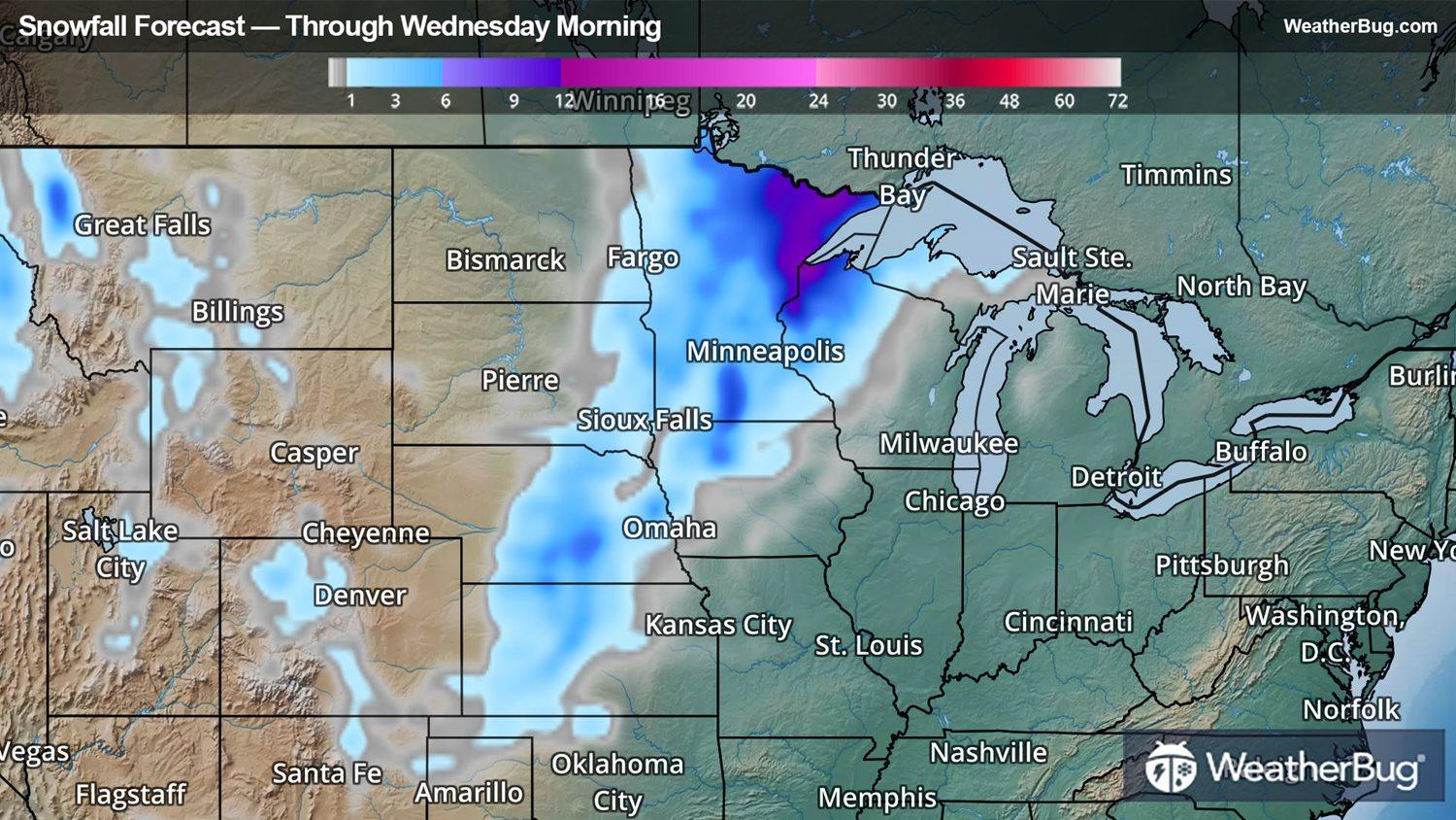
As this system pushes further northeastward today, parts of the Plains and Upper Mississippi Valley will see additional snowfall and windy conditions. In fact, snow will likely linger into Wednesday as this system exits over the Great Lakes.
Winter Storm Warnings and Winter Weather Advisories remain in place across northern Iowa, most of Minnesota and western Wisconsin. This includes Estherville, Iowa, Minneapolis, Hibbing and International Falls, Minn., and Hayward, Wis. Additional accumulations on the order of 3 to 6 inches will be possible within this region, bringing storm snow totals to nearly 2 feet in some places across central and eastern Minnesota and northern Wisconsin.
As if that weren’t bad enough, strong easterly winds possibly gusting as high as 50 to 60 mph will blow and drift the falling snow and producing blizzard-like conditions and making driving difficult with visibilities near zero. A light glaze to a quarter inch of ice will be possible along and south of Interstate 80 southward as well, making travel conditions that much more dangerous.
This system is a two-part threat with the southern and eastern fringes packing severe weather threats today. Parts of the southern Great Lakes and Ohio Valley as well as the Gulf Coast will have to watch for severe thunderstorms erupting this afternoon as a stout cold front sweeps through. Meanwhile, strong winds will kick up across the Ohio and Tennessee valleys as well as the Southeast today, prompting Wind Advisories here. Wind gusts topping 50 to 60 mph today will be likely, but areas across central and eastern Tennessee may see gusts up to 80 mph through this afternoon.
While the season has already changed to spring, this spring winter storm could well represent the biggest snowmaker of the season across the northern Plains. Minneapolis recorded over 8 inches of snowfall on Monday, breaking the previous daily snowfall record of 6.8 inches that was set in 1996. International Falls, Minn., also broke their record for daily snowfall on Monday when nearly 6 inches fell, shattering the 1954 record of 2.6 inches.
While much of this week will feature quieter weather under high pressure, the longer-range forecasts indicate a rinse-and-repeat pattern as we approach Easter weekend and the first week of April.