Wednesday's Weather Outlook
Winter weather will be limited to the taller terrain of the two northern U.S. corners for the midpoint of the week. Warm, dry weather will otherwise dominate with a caveat or two along the Gulf Coast.
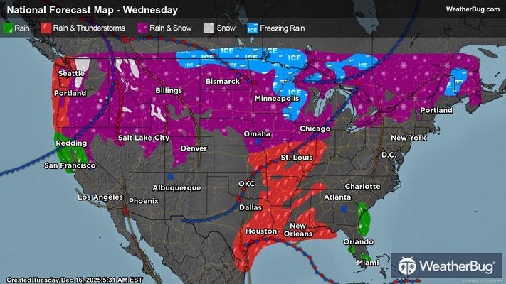
A potent storm racing across western Canada will deliver mountain snow in the Oregon and Washington Cascades to the northern Rocky Front Range throughout the day on Wednesday. The Pacific beaches and Northwest and Western U.S. valleys will be drenched by rain, which may lead to flooding, particularly in flood-prone, poor drainage urban locations. Landslides in steep terrain and debris flows will be possible as well in the Cascades and taller surrounding hills. Meanwhile, several inches to measuring feet of snow with a yardstick is forecast, especially at the tallest peaks.
Potentially damaging wind gusts will make up the other part of the storm’s craziness along the U.S. and Canada border throughout the day as well. A long period of gusts ranging from 50 to 90 mph will lead to widespread power outages from downed trees and tree limbs/branches. These magnitude gusts will also make driving extremely difficult to impossible, whipping snow about at high altitudes, and blowing about objects not tied down or brought inside. Make sure to check ahead about chain requirements if you are traveling through the taller terrain in the Northwest to Montana.
Meanwhile, a bit of wintry precipitation will likely be found mixed in with rain showers from the Mid-Atlantic’s Blue Ridge and Appalachia to Upstate New York and northern New England. A skiff to an inch or a bit more snow in addition to a trace of ice accumulation could make travel slick near the eastern Great Lakes, and from Upstate New York to near the U.S. and Canada border from Vermont and New Hampshire to Maine.
The eastern third of Texas, including the Gulf Coast, to the Lower Mississippi Valley and Deep South will have to dodge rain and embedded thunderstorms on Wednesday, particularly through mid to late during the afternoon. Gradually improving weather is expected by the evening rush, however. A few showers may pivot inland near the Florida Atlantic beaches as well during the afternoon and evening. Most of the day should remain dry, however.
Plentiful sunshine and a much-needed winter thaw will greet most of the nation for midweek. Highs will be near to above normal across the entirety of the U.S. The coldest highs will be found in the Cascades where teens and 20s will be common. Thirties, 40s, 50s, and 60s will dominate most of the nation, while 60s and 70s will blanket the U.S. Southern-Tier, the western High Plains, and much of the Southwest. A few lower 80s could pop up in the California deserts as well.