Wednesday's Weather Outlook
This Wednesday, active weather persists across parts of the East, South, and Central U.S., while much of the West stays dry. However, some areas may see a more organized severe weather threat compared to recent days.
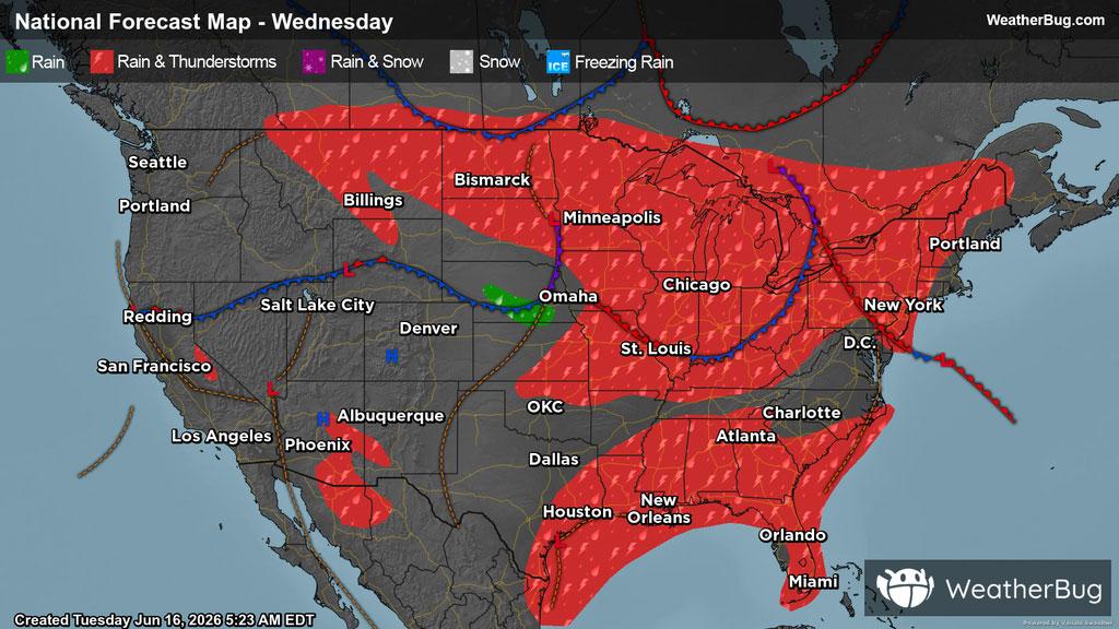
A stormy setup extends from the High Plains through the Midwest and Northeast this Wednesday, where the area will experience cloud cover, showers, and thunderstorms throughout the day, with activity becoming more widespread amongst the region in the afternoon hours.
There is a severe weather threat with these storms, particularly in the Eastern Plains and the Lower Midwest. The greatest risk will be in much of Missouri, eastern Iowa, Illinois, Indiana, and western Ohio, where the main concerns will be hail, damaging winds, and tornadoes. The best way you can remain safe is to stay prepared and informed about your local weather and to remember, "When Thunder Roars, Go Indoors!"
In the Mid-Atlantic up through the Northeast, expect clouds to move into the region later in the day, with isolated showers and thunderstorms in the afternoon and evening hours.
Down in the Southeast, warm, humid air flowing from the Gulf of Mexico will continue support convective activity, where plenty of tropical moisture in the region may lead to further flooding concerns and the potential for travel delays.
Meanwhile, the weather in the West is defined by upper-level high, along with limited moisture will keep much of the region calm, where the Pacific Northwest down through California, into the Great Basin, Lower Mountain West, and through western Texas. can anticipate for the most part to stay high and dry, with clear and partly cloudy skies. However, local disturbances in inland central California, southern, central, and western Arizona, along with southeastern New Mexico may lead to the aforementioned areas experiencing an isolated shower or thunderstorm in the afternoon and evening hours.
Unseasonably cool temperatures will settle across the High Plains, Upper Midwest, and the Northeast U.S., where highs will be in the 60s and 70s. The Mid-Atlantic, Southeast, Lower Midwest, and much of the South-Central U.S. can anticipate high temperatures to be in the 80s and 90s. The Western U.S. will see great variations in high temperatures, ranging from the 80s to over 100 degrees, where much of the latter will be seen in the Desert Southwest, in addition to western Texas and the Southwestern Plains. However, In the Mountain West, regions of higher elevations can expect temperatures in the 50s and 60s. Meanwhile, the rest of the U.S. can expect highs in the 70s and 80s. However, there could be more fluctuations in localized areas.