Back to forecast
Eastern Seaboard Braces For Big Afternoon Storms
March 28, 2021 at 05:20 PM EDT
UPDATED By WeatherBug Meteorologist, Fred Allen
Parts of the Eastern Seaboard could be peppered by dangerous weather to finish off a chaotic weekend full of severe weather for many east of the Mississippi River. Damaging wind, large hail and even a few tornadoes will be possible.
A robust area of low pressure will race from Canada’s Ontario Province this afternoon to north of Atlantic Canada Monday. This will pave the way for a powerful cold front to pull away from the Atlantic Seaboard tonight.
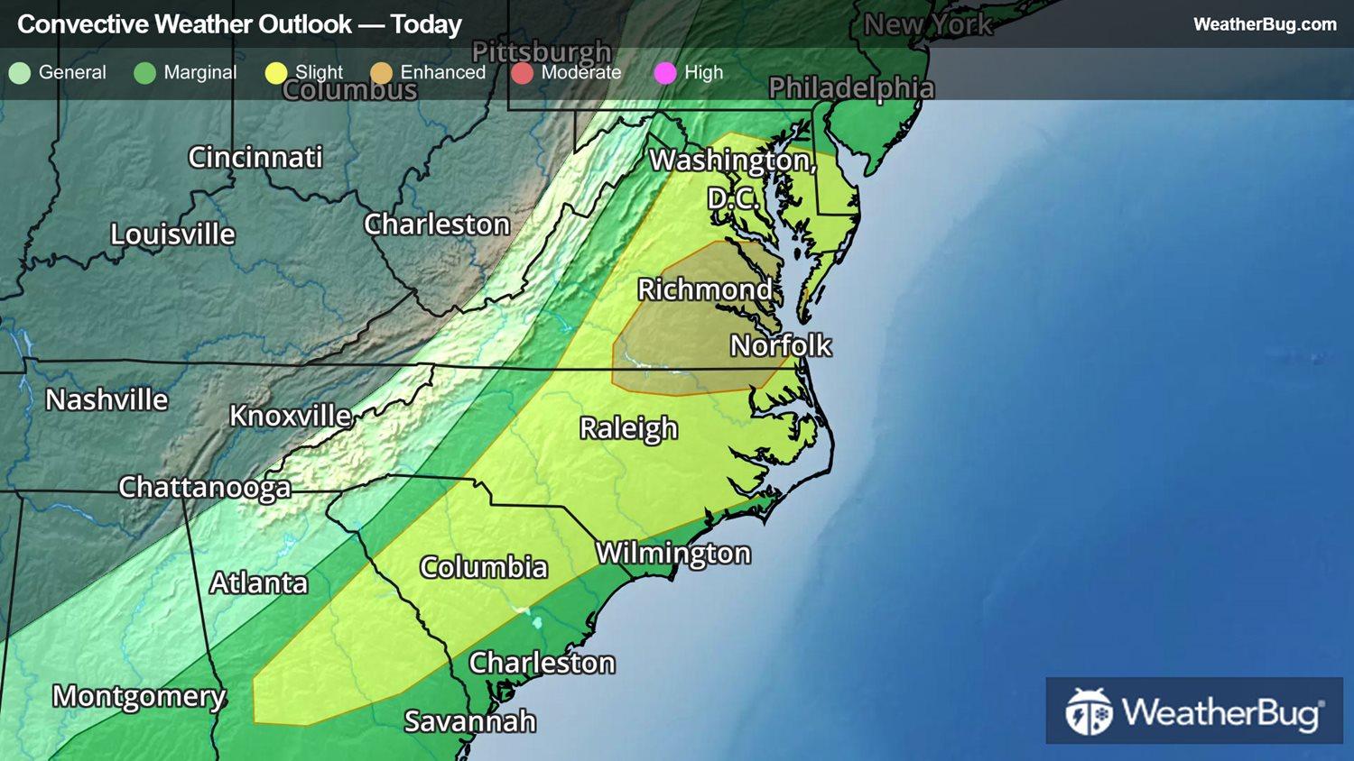
The clash between spring and autumn-like air masses along the boundary is providing the fuel for big thunderstorms along and east of the Appalachian Spine from Georgia to Connecticut and southwestern Massachusetts. Already lined up from eastern Alabama to near South Carolina’s Interstate 20 corridor, thunderstorms may intensify while rumbling toward the Georgia and South Carolina beaches by this evening. A second lengthy line consolidating and moving from interior North Carolina to southern New England will race to the Mid-Atlantic beaches by early tonight.
A Severe Thunderstorm Watch is in place for east-central and northeastern North Carolina and far southeastern Virginia, including Fayetteville, N.C., and Norfolk, Va. A new Severe Thunderstorm Watch has been issued for northeastern Virginia, the District of Columbia and eastern Maryland into southern or south-central New Jersey. Washington, D.C., Baltimore, Dover and Wilmington, Del., Atlantic City, N.J., and Philadelphia are included.
Hartford, Conn., New York City, Newark and Trenton, N.J., Philadelphia and Allentown, Pa., Baltimore, Washington, D.C., Richmond and Norfolk, Va., Raleigh-Durham and Charlotte, N.C., Columbia, S.C, and Augusta, Ga., are several cities that will need to keep a watchful eye to the sky for threatening weather.
The major headache accompanying the severe weather will be destructive wind gusts peaking at 60 to 70 mph, although a few short-lived tornadoes would be possible as well. A couple reports of hail larger than quarters cannot be ruled out either.
This is all part of the same storm that resulted in more than 210 severe weather reports on Saturday from far eastern Texas all the way to Indiana, Ohio, and as far east as southwestern Virginia and eastern North Carolina. There were 15 possible tornado touchdowns, including one that rolled through Lexington, Tenn., leaving at least five structures with major damage and three with minor damage. Tennis ball sized hail fell near Prescott, Ark., while Gurdon and South Bend, Ark., were pelted by hail larger than baseball size. A thunderstorm gust measured at 62 mph occurred in Madison, Ill., while a gust to 61 mph was clocked at Taylorville Airport in Illinois on Saturday evening.
If you are planning to be outside at all today, pay very close attention to the weather, and be prepared to seek shelter immediately if the sky darkens in your neighborhood. Make sure you have a weather radio available or warnings on your phone to provide you with additional lead time ahead of the storms.
A robust area of low pressure will race from Canada’s Ontario Province this afternoon to north of Atlantic Canada Monday. This will pave the way for a powerful cold front to pull away from the Atlantic Seaboard tonight.
The clash between spring and autumn-like air masses along the boundary is providing the fuel for big thunderstorms along and east of the Appalachian Spine from Georgia to Connecticut and southwestern Massachusetts. Already lined up from eastern Alabama to near South Carolina’s Interstate 20 corridor, thunderstorms may intensify while rumbling toward the Georgia and South Carolina beaches by this evening. A second lengthy line consolidating and moving from interior North Carolina to southern New England will race to the Mid-Atlantic beaches by early tonight.
A Severe Thunderstorm Watch is in place for east-central and northeastern North Carolina and far southeastern Virginia, including Fayetteville, N.C., and Norfolk, Va. A new Severe Thunderstorm Watch has been issued for northeastern Virginia, the District of Columbia and eastern Maryland into southern or south-central New Jersey. Washington, D.C., Baltimore, Dover and Wilmington, Del., Atlantic City, N.J., and Philadelphia are included.
Hartford, Conn., New York City, Newark and Trenton, N.J., Philadelphia and Allentown, Pa., Baltimore, Washington, D.C., Richmond and Norfolk, Va., Raleigh-Durham and Charlotte, N.C., Columbia, S.C, and Augusta, Ga., are several cities that will need to keep a watchful eye to the sky for threatening weather.
The major headache accompanying the severe weather will be destructive wind gusts peaking at 60 to 70 mph, although a few short-lived tornadoes would be possible as well. A couple reports of hail larger than quarters cannot be ruled out either.
This is all part of the same storm that resulted in more than 210 severe weather reports on Saturday from far eastern Texas all the way to Indiana, Ohio, and as far east as southwestern Virginia and eastern North Carolina. There were 15 possible tornado touchdowns, including one that rolled through Lexington, Tenn., leaving at least five structures with major damage and three with minor damage. Tennis ball sized hail fell near Prescott, Ark., while Gurdon and South Bend, Ark., were pelted by hail larger than baseball size. A thunderstorm gust measured at 62 mph occurred in Madison, Ill., while a gust to 61 mph was clocked at Taylorville Airport in Illinois on Saturday evening.
If you are planning to be outside at all today, pay very close attention to the weather, and be prepared to seek shelter immediately if the sky darkens in your neighborhood. Make sure you have a weather radio available or warnings on your phone to provide you with additional lead time ahead of the storms.