Back to forecast
Weekend Weather Preview
September 16, 2021 at 07:38 PM EDT
By WeatherBug's Ali Husain
A dome of high-pressure building over the northern Plains brings unseasonably warm temperatures ranging from 25 to 30 degrees above average, while frigid air behind a cold front slices into the Pacific Northwest.
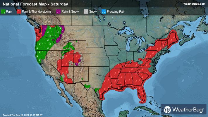
Saturday:
Temperatures in the upper 80s and lower 90s will be found in the northern Tier and northern Plains, up to 30 degrees above average for this time of the year. Just a bit to the west, a cold front begins slicing into the Pacific northwest, carrying cool temperatures 10 to 15 degrees below average. Highs will be in the mid-to-upper 60s and lower 70s, with some mountaintops experiencing some of the first snowfall of the season. The cool rainfall expected this weekend will be a blessing for the drought-stricken grounds in the Northwest.
This cooler air extends southward into central California, with highs expected in the upper 70s and lower 80s. Moving down the coast into the Desert Southwest, more typical temperatures in the lower 100s and upper 90s are forecast, dropping into the mid-80s in the Great Basin and Intermountain West.
The central and southern Plains see similar temperatures Saturday, in the mid-to-lower 90s, stretching to triple digits in extreme southern Texas.
Rainfall associated with Tropical Depression Nicholas continues to pour on the South and Southeast, bringing cooler temperatures in the mid-to-lower 80s, rising to the upper 80s in southern Florida.
In the Great Lakes and Mid-Atlantic, temperatures 5 to 10 degrees above average yield highs in the mid-to-upper 80s, dropping to the upper 70s and lower 80s in the upper Midwest and Northeast, with rain chances stretching from the Tennessee Valley to Maine.
Sunday:
The cool air expands further into central California and the greater Pacific Northwest on Sunday, bringing temperatures 20 to 25 degrees below average in the upper 50s to lower 60s. Cooling rains are expected to fall behind the cold front, bringing much-needed fire relief for the massive blazes in northern California.
Temperatures in the mid-to-lower 70s will be found across central California and the northern Great Basin, rising to more seasonably warm temperatures moving south. In the Desert Southwest, highs will remain in the lower 100s and upper 90s.
The dome of high-pressure expands eastwards, bringing a large swath of unseasonably warm temperatures ranging from 15 to 30 degrees above average to the northern and central Plains, upper Midwest and western Great Lakes. Temperatures in the Dakotas and Minnesota could reach the mid-90s, with similar highs expected for the central Plains. The upper Midwest and western Great Lakes will be slightly cooler, in the mid-to-upper 80s.
The Northeast and Mid-Atlantic have a similar outlook as Sunday, with temperatures in the mid-to-upper 70s expected for New England and mid-80s for the Mid-Atlantic. In the South and Southeast, plenty of rain from Tropical Depression Nicholas continues to inundate the already-soaked Cotton Belt, with highs in the upper 70s and lower 80s, rising to the mid-to-upper 80s in the Florida Peninsula.